Schoharie Topo Map New York
To zoom in, hover over the map of Schoharie
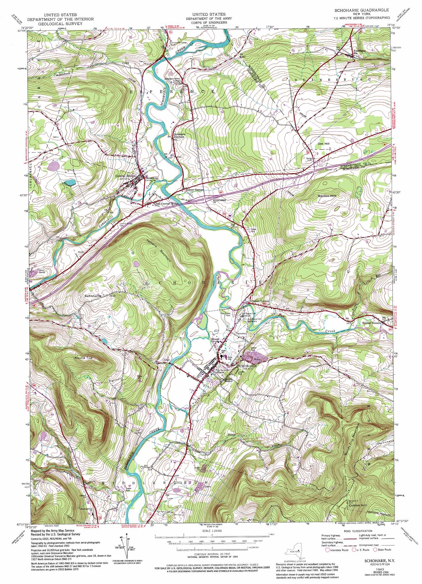
USGS Topo Quad 42074f3 - 1:24,000 scale
| Topo Map Name: | Schoharie |
| USGS Topo Quad ID: | 42074f3 |
| Print Size: | ca. 21 1/4" wide x 27" high |
| Southeast Coordinates: | 42.625° N latitude / 74.25° W longitude |
| Map Center Coordinates: | 42.6875° N latitude / 74.3125° W longitude |
| U.S. State: | NY |
| Filename: | o42074f3.jpg |
| Download Map JPG Image: | Schoharie topo map 1:24,000 scale |
| Map Type: | Topographic |
| Topo Series: | 7.5´ |
| Map Scale: | 1:24,000 |
| Source of Map Images: | United States Geological Survey (USGS) |
| Alternate Map Versions: |
Schoharie NY 1943, updated 1959 Download PDF Buy paper map Schoharie NY 1943, updated 1972 Download PDF Buy paper map Schoharie NY 1943, updated 1980 Download PDF Buy paper map Schoharie NY 1943, updated 1994 Download PDF Buy paper map Schoharie NY 2010 Download PDF Buy paper map Schoharie NY 2013 Download PDF Buy paper map Schoharie NY 2016 Download PDF Buy paper map |
1:24,000 Topo Quads surrounding Schoharie
Canajoharie |
Randall |
Tribes Hill |
Amsterdam |
Pattersonville |
Sharon Springs |
Carlisle |
Esperance |
Duanesburg |
Rotterdam Junction |
Richmondville |
Cobleskill |
Schoharie |
Gallupville |
Altamont |
Summit |
Breakabeen |
Middleburgh |
Rensselaerville |
Westerlo |
Stamford |
Gilboa |
Livingstonville |
Durham |
Greenville |
> Back to 42074e1 at 1:100,000 scale
> Back to 42074a1 at 1:250,000 scale
> Back to U.S. Topo Maps home
Schoharie topo map: Gazetteer
Schoharie: Bridges
Schoharie Bridge elevation 183m 600′Schoharie: Mines
Schoharie Quarry elevation 260m 853′Schoharie: Parks
Central Bridge Community Park elevation 182m 597′Fox Creek Park elevation 183m 600′
Lasalle Park elevation 233m 764′
Schoharie: Populated Places
Central Bridge elevation 189m 620′Old Central Bridge elevation 184m 603′
Schoharie elevation 183m 600′
Schoharie Junction elevation 185m 606′
Shutter Corners elevation 206m 675′
Schoharie: Streams
Cobleskill Creek elevation 171m 561′Cripplebush Creek elevation 172m 564′
Fly Creek elevation 168m 551′
Fox Creek elevation 178m 583′
Louse Kill elevation 197m 646′
Stony Brook elevation 177m 580′
Schoharie: Summits
Barton Hill elevation 433m 1420′Cotton Hill elevation 643m 2109′
Oak Hill elevation 375m 1230′
Round Top elevation 489m 1604′
Rundy Cup Mountain elevation 570m 1870′
Schoharie Hill elevation 423m 1387′
Terrace Mountain elevation 422m 1384′
Schoharie digital topo map on disk
Buy this Schoharie topo map showing relief, roads, GPS coordinates and other geographical features, as a high-resolution digital map file on DVD:
New York, Vermont, Connecticut & Western Massachusetts
Buy digital topo maps: New York, Vermont, Connecticut & Western Massachusetts