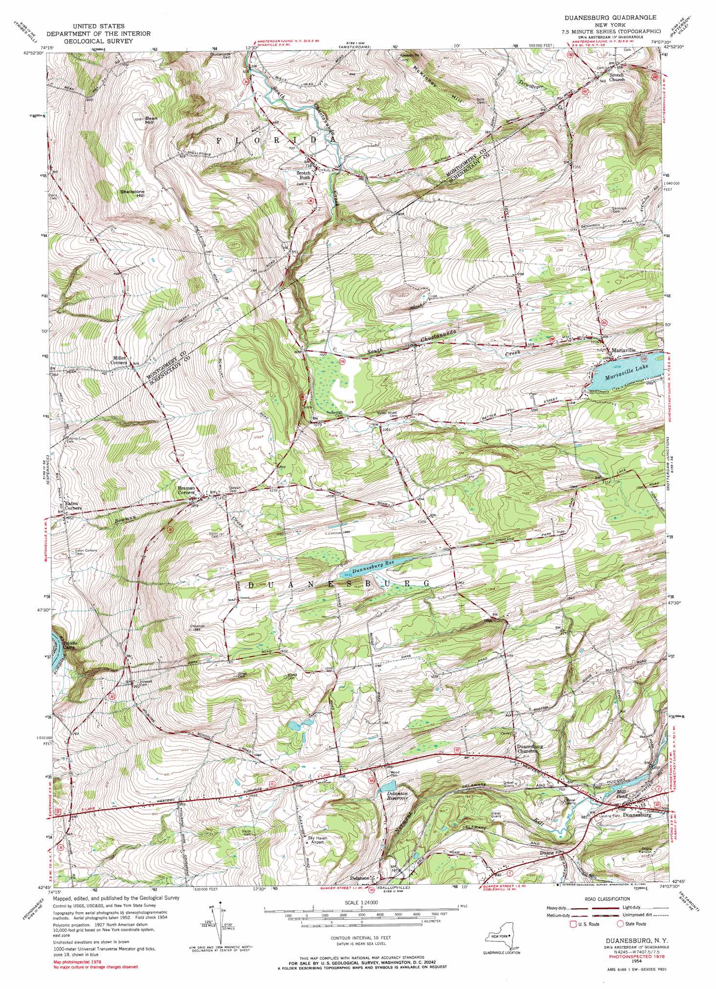
Duanesburg Topo Map New York
To zoom in, hover over the map of Duanesburg
USGS Topo Quad 42074g2 - 1:24,000 scale
| Topo Map Name: | Duanesburg |
| USGS Topo Quad ID: | 42074g2 |
| Print Size: | ca. 21 1/4" wide x 27" high |
| Southeast Coordinates: | 42.75° N latitude / 74.125° W longitude |
| Map Center Coordinates: | 42.8125° N latitude / 74.1875° W longitude |
| U.S. State: | NY |
| Filename: | o42074g2.jpg |
| Download Map JPG Image: | Duanesburg topo map 1:24,000 scale |
| Map Type: | Topographic |
| Topo Series: | 7.5´ |
| Map Scale: | 1:24,000 |
| Source of Map Images: | United States Geological Survey (USGS) |
| Alternate Map Versions: |
Duanesburg NY 1954, updated 1956 Download PDF Buy paper map Duanesburg NY 1954, updated 1970 Download PDF Buy paper map Duanesburg NY 1954, updated 1984 Download PDF Buy paper map Duanesburg NY 2010 Download PDF Buy paper map Duanesburg NY 2013 Download PDF Buy paper map Duanesburg NY 2016 Download PDF Buy paper map |
1:24,000 Topo Quads surrounding Duanesburg
Peck Lake |
Gloversville |
Broadalbin |
Galway |
Middle Grove |
Randall |
Tribes Hill |
Amsterdam |
Pattersonville |
Burnt Hills |
Carlisle |
Esperance |
Duanesburg |
Rotterdam Junction |
Schenectady |
Cobleskill |
Schoharie |
Gallupville |
Altamont |
Voorheesville |
Breakabeen |
Middleburgh |
Rensselaerville |
Westerlo |
Clarksville |
> Back to 42074e1 at 1:100,000 scale
> Back to 42074a1 at 1:250,000 scale
> Back to U.S. Topo Maps home
Duanesburg topo map: Gazetteer
Duanesburg: Airports
Duanesburg Airport elevation 216m 708′Duanesburg: Lakes
Duanespurg Reservoir elevation 409m 1341′Mill Pond elevation 199m 652′
Duanesburg: Populated Places
Braman Corners elevation 335m 1099′Duane elevation 257m 843′
Duanesburg elevation 219m 718′
Eaton Corners elevation 202m 662′
Mariaville elevation 389m 1276′
Mariaville Lake elevation 393m 1289′
Miller Corners elevation 278m 912′
Scotch Bush elevation 216m 708′
Scotch Church elevation 294m 964′
Duanesburg: Reservoirs
Delanson Reservoir elevation 293m 961′Duanesburg: Summits
Bean Hill elevation 369m 1210′McKinney Hill elevation 319m 1046′
Shellstone Hill elevation 362m 1187′
Duanesburg digital topo map on disk
Buy this Duanesburg topo map showing relief, roads, GPS coordinates and other geographical features, as a high-resolution digital map file on DVD:
New York, Vermont, Connecticut & Western Massachusetts
Buy digital topo maps: New York, Vermont, Connecticut & Western Massachusetts