South Otselic Topo Map New York
To zoom in, hover over the map of South Otselic
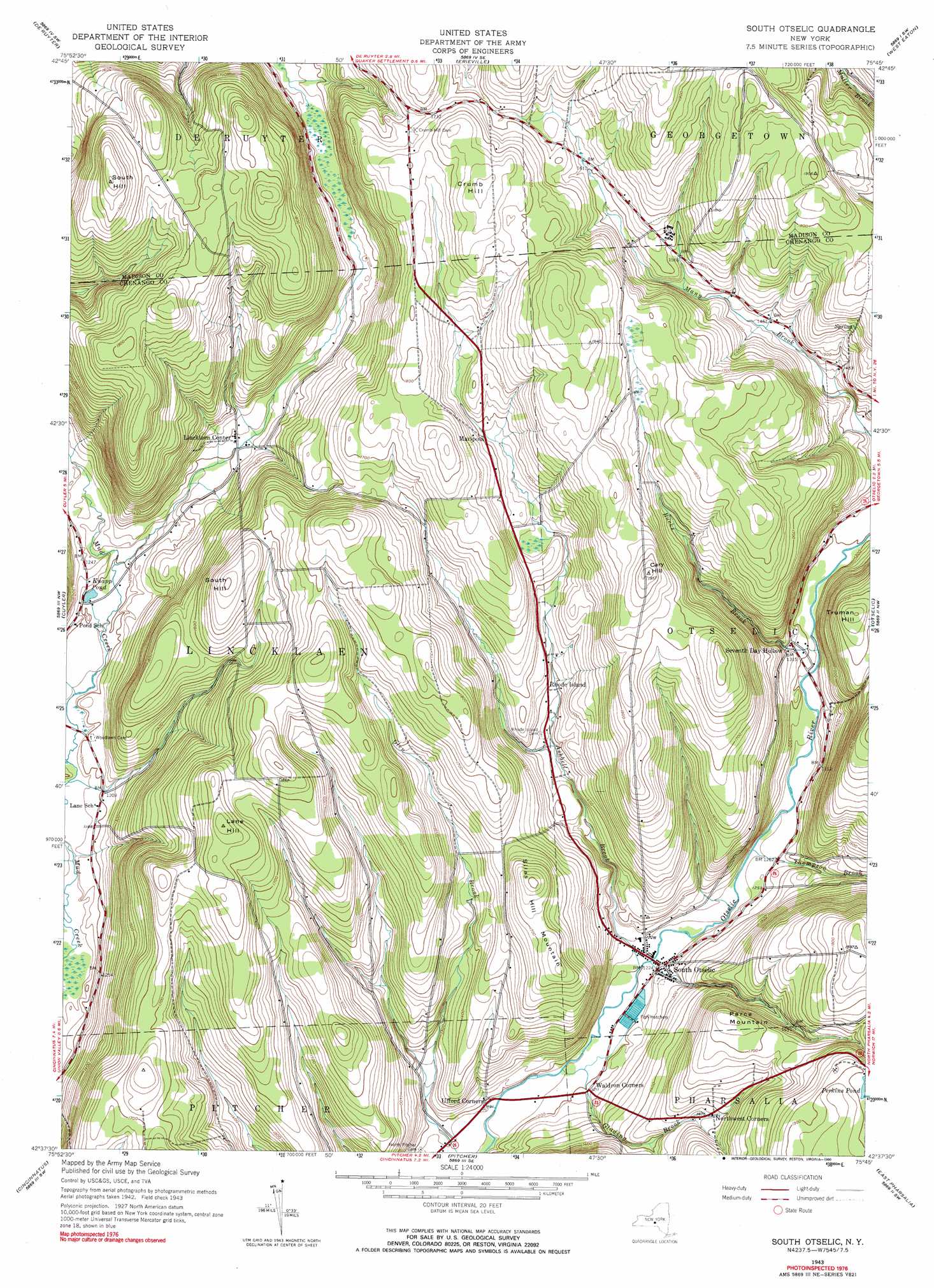
USGS Topo Quad 42075f7 - 1:24,000 scale
| Topo Map Name: | South Otselic |
| USGS Topo Quad ID: | 42075f7 |
| Print Size: | ca. 21 1/4" wide x 27" high |
| Southeast Coordinates: | 42.625° N latitude / 75.75° W longitude |
| Map Center Coordinates: | 42.6875° N latitude / 75.8125° W longitude |
| U.S. State: | NY |
| Filename: | o42075f7.jpg |
| Download Map JPG Image: | South Otselic topo map 1:24,000 scale |
| Map Type: | Topographic |
| Topo Series: | 7.5´ |
| Map Scale: | 1:24,000 |
| Source of Map Images: | United States Geological Survey (USGS) |
| Alternate Map Versions: |
South Ostelic NY 1943, updated 1960 Download PDF Buy paper map South Ostelic NY 1943, updated 1973 Download PDF Buy paper map South Otselic NY 1943, updated 1990 Download PDF Buy paper map South Otselic NY 2010 Download PDF Buy paper map South Otselic NY 2013 Download PDF Buy paper map South Otselic NY 2016 Download PDF Buy paper map |
1:24,000 Topo Quads surrounding South Otselic
Jamesville |
Oran |
Cazenovia |
Morrisville |
Munnsville |
Tully |
De Ruyter |
Erieville |
West Eaton |
Hamilton |
Truxton |
Cuyler |
South Otselic |
Otselic |
Earlville |
Mcgraw |
Cincinnatus |
Pitcher |
East Pharsalia |
Norwich |
Marathon |
Willet |
Smithville Flats |
Tyner |
Oxford |
> Back to 42075e1 at 1:100,000 scale
> Back to 42074a1 at 1:250,000 scale
> Back to U.S. Topo Maps home
South Otselic topo map: Gazetteer
South Otselic: Lakes
Knapp Pond elevation 365m 1197′South Otselic: Populated Places
Lincklaen Center elevation 401m 1315′Mariposa elevation 485m 1591′
Northwest Corners elevation 450m 1476′
Rhode Island elevation 430m 1410′
Seventh Day Hollow elevation 407m 1335′
South Otselic elevation 374m 1227′
South Otselic: Streams
Ashbell Brook elevation 362m 1187′Bucks Brook elevation 384m 1259′
Glading Brook elevation 355m 1164′
Thompson Brook elevation 372m 1220′
South Otselic: Summits
Cary Hill elevation 594m 1948′Crumb Hill elevation 574m 1883′
Lane Hill elevation 570m 1870′
Parce Mountain elevation 532m 1745′
Silas Hill Mountain elevation 550m 1804′
South Hill elevation 550m 1804′
South Hill elevation 604m 1981′
Truman Hill elevation 543m 1781′
South Otselic digital topo map on disk
Buy this South Otselic topo map showing relief, roads, GPS coordinates and other geographical features, as a high-resolution digital map file on DVD:
New York, Vermont, Connecticut & Western Massachusetts
Buy digital topo maps: New York, Vermont, Connecticut & Western Massachusetts