Kennedy Topo Map New York
To zoom in, hover over the map of Kennedy
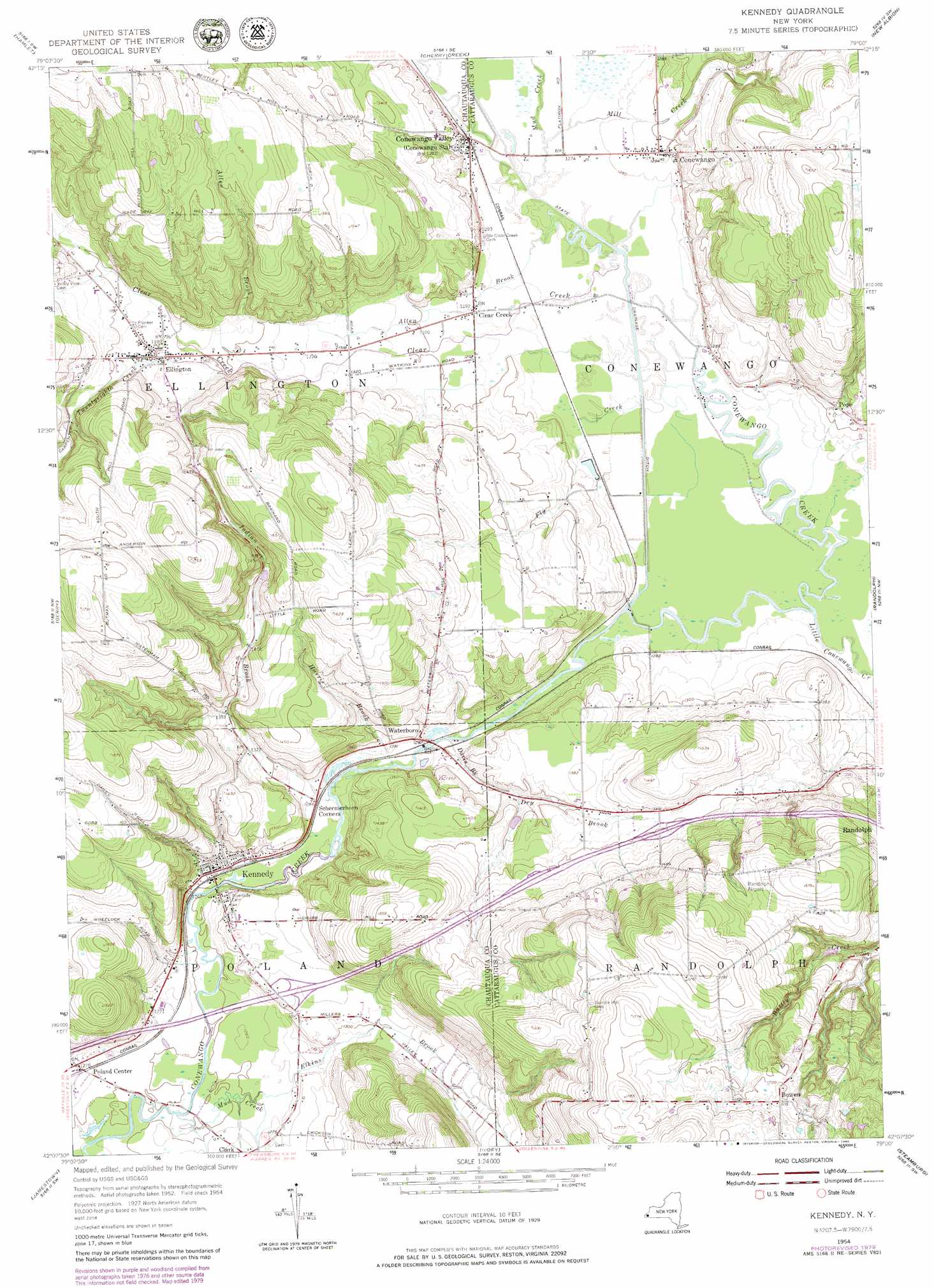
USGS Topo Quad 42079b1 - 1:24,000 scale
| Topo Map Name: | Kennedy |
| USGS Topo Quad ID: | 42079b1 |
| Print Size: | ca. 21 1/4" wide x 27" high |
| Southeast Coordinates: | 42.125° N latitude / 79° W longitude |
| Map Center Coordinates: | 42.1875° N latitude / 79.0625° W longitude |
| U.S. State: | NY |
| Filename: | o42079b1.jpg |
| Download Map JPG Image: | Kennedy topo map 1:24,000 scale |
| Map Type: | Topographic |
| Topo Series: | 7.5´ |
| Map Scale: | 1:24,000 |
| Source of Map Images: | United States Geological Survey (USGS) |
| Alternate Map Versions: |
Kennedy NY 1954, updated 1955 Download PDF Buy paper map Kennedy NY 1954, updated 1976 Download PDF Buy paper map Kennedy NY 1954, updated 1980 Download PDF Buy paper map Kennedy NY 1979, updated 1980 Download PDF Buy paper map Kennedy NY 2010 Download PDF Buy paper map Kennedy NY 2013 Download PDF Buy paper map Kennedy NY 2016 Download PDF Buy paper map |
1:24,000 Topo Quads surrounding Kennedy
Dunkirk |
Forestville |
Perrysburg |
Gowanda |
Collins Center |
Cassadaga |
Hamlet |
Cherry Creek |
New Albion |
Cattaraugus |
Ellery Center |
Gerry |
Kennedy |
Randolph |
Little Valley |
Lakewood |
Jamestown |
Ivory |
Steamburg |
Red House |
Sugar Grove |
Russell |
Scandia |
Cornplanter Run |
Stickney |
> Back to 42079a1 at 1:100,000 scale
> Back to 42078a1 at 1:250,000 scale
> Back to U.S. Topo Maps home
Kennedy topo map: Gazetteer
Kennedy: Airports
Randolph Airport elevation 502m 1646′Kennedy: Populated Places
Bowen elevation 521m 1709′Clear Creek elevation 393m 1289′
Conewango elevation 394m 1292′
Conewango Valley elevation 393m 1289′
Ellington elevation 418m 1371′
Kennedy elevation 386m 1266′
Poland Center elevation 388m 1272′
Pope elevation 401m 1315′
Waterboro elevation 394m 1292′
Kennedy: Streams
Allen Brook elevation 387m 1269′Clear Creek elevation 387m 1269′
Davis Brook elevation 382m 1253′
Dry Brook elevation 399m 1309′
Elkins Brook elevation 381m 1250′
Fly Creek elevation 384m 1259′
Harris Brook elevation 383m 1256′
Indian Brook elevation 382m 1253′
Little Conewango Creek elevation 383m 1256′
Mill Creek elevation 387m 1269′
Mud Creek elevation 377m 1236′
Mud Creek elevation 387m 1269′
Twentyeighth Creek elevation 411m 1348′
Kennedy digital topo map on disk
Buy this Kennedy topo map showing relief, roads, GPS coordinates and other geographical features, as a high-resolution digital map file on DVD:
 map DVD")