Russell Topo Map Pennsylvania
To zoom in, hover over the map of Russell
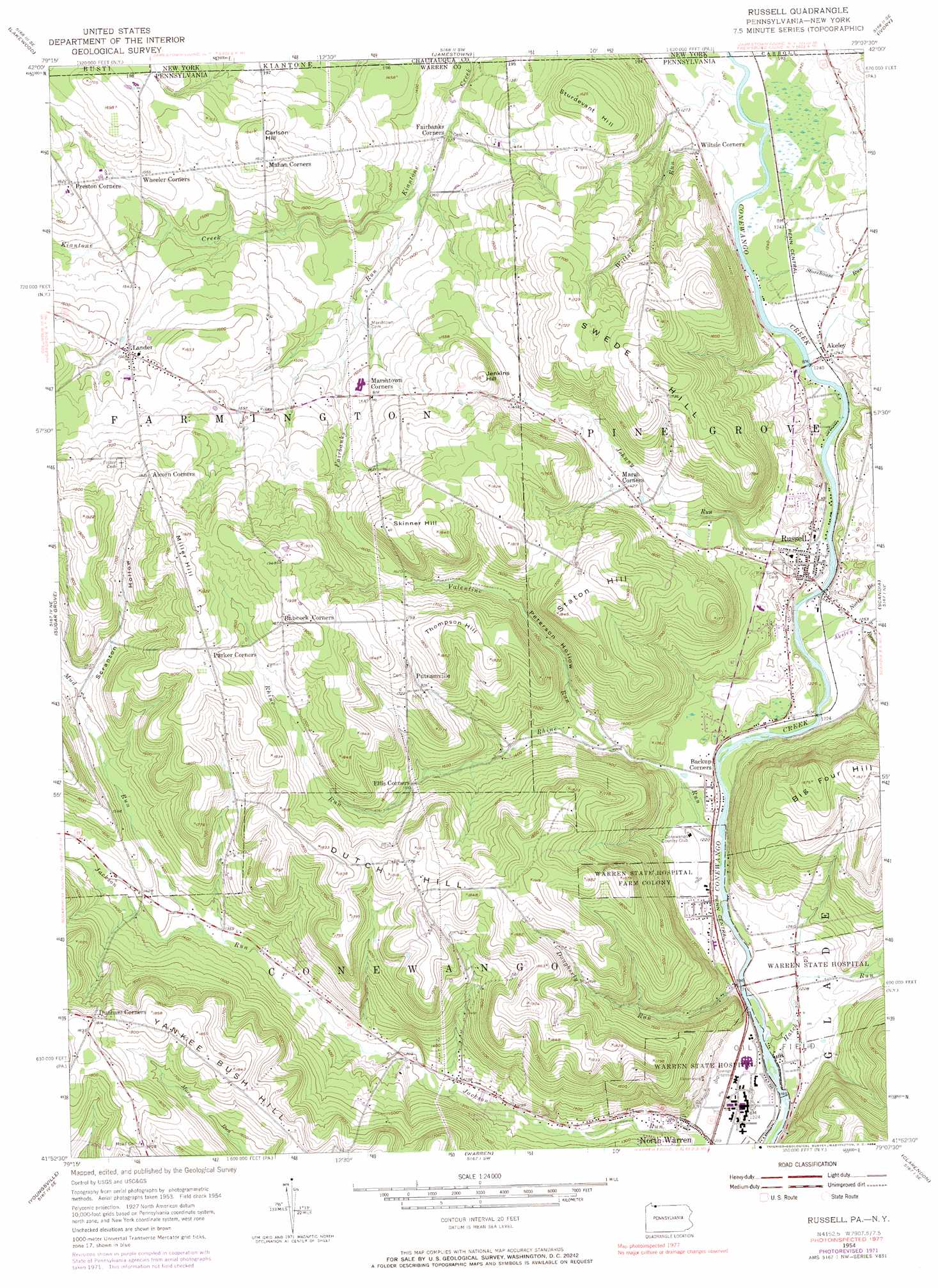
USGS Topo Quad 41079h2 - 1:24,000 scale
| Topo Map Name: | Russell |
| USGS Topo Quad ID: | 41079h2 |
| Print Size: | ca. 21 1/4" wide x 27" high |
| Southeast Coordinates: | 41.875° N latitude / 79.125° W longitude |
| Map Center Coordinates: | 41.9375° N latitude / 79.1875° W longitude |
| U.S. States: | PA, NY |
| Filename: | o41079h2.jpg |
| Download Map JPG Image: | Russell topo map 1:24,000 scale |
| Map Type: | Topographic |
| Topo Series: | 7.5´ |
| Map Scale: | 1:24,000 |
| Source of Map Images: | United States Geological Survey (USGS) |
| Alternate Map Versions: |
Russell PA 1954, updated 1956 Download PDF Buy paper map Russell PA 1954, updated 1966 Download PDF Buy paper map Russell PA 1954, updated 1972 Download PDF Buy paper map Russell PA 1954, updated 1984 Download PDF Buy paper map Russell PA 2010 Download PDF Buy paper map Russell PA 2013 Download PDF Buy paper map Russell PA 2016 Download PDF Buy paper map |
1:24,000 Topo Quads surrounding Russell
Chautauqua |
Ellery Center |
Gerry |
Kennedy |
Randolph |
Panama |
Lakewood |
Jamestown |
Ivory |
Steamburg |
Lottsville |
Sugar Grove |
Russell |
Scandia |
Cornplanter Run |
Pittsfield |
Youngsville |
Warren |
Clarendon |
Cornplanter Bridge |
Tidioute |
Cobham |
Cherry Grove |
Sheffield |
Ludlow |
> Back to 41079e1 at 1:100,000 scale
> Back to 41078a1 at 1:250,000 scale
> Back to U.S. Topo Maps home
Russell topo map: Gazetteer
Russell: Airports
D O C Airport elevation 421m 1381′Russell: Parks
State Game Lands Number 282 elevation 377m 1236′Russell: Populated Places
Akeley elevation 380m 1246′Backup Corners elevation 376m 1233′
Jackson Run elevation 434m 1423′
Lander elevation 477m 1564′
Putnamville elevation 506m 1660′
Russell elevation 383m 1256′
Russell: Post Offices
Ackley Station Post Office (historical) elevation 380m 1246′Russell: Streams
Akeley Run elevation 372m 1220′Dougherty Run elevation 370m 1213′
Fairbanks Run elevation 405m 1328′
Hatch Run elevation 364m 1194′
Johnny Run elevation 372m 1220′
Mud Run elevation 413m 1354′
North Branch Akeley Run elevation 372m 1220′
Rhine Run elevation 366m 1200′
Rollin Run elevation 436m 1430′
Storehouse Run elevation 376m 1233′
Valentine Run elevation 396m 1299′
Wiltsie Run elevation 372m 1220′
Russell: Summits
Big Four Hill elevation 568m 1863′Carlson Hill elevation 498m 1633′
Dutch Hill elevation 550m 1804′
Jenkins Hill elevation 516m 1692′
Skinner Hill elevation 560m 1837′
Staton Hill elevation 561m 1840′
Sturdevant Hill elevation 495m 1624′
Sturdevant Hill elevation 497m 1630′
Swede Hill elevation 556m 1824′
Thompson Hill elevation 564m 1850′
Russell: Valleys
Peterson Hollow elevation 423m 1387′Scranton Hollow elevation 463m 1519′
Simons Hollow elevation 385m 1263′
Russell digital topo map on disk
Buy this Russell topo map showing relief, roads, GPS coordinates and other geographical features, as a high-resolution digital map file on DVD:
 map DVD")