Bangor Topo Map Michigan
To zoom in, hover over the map of Bangor
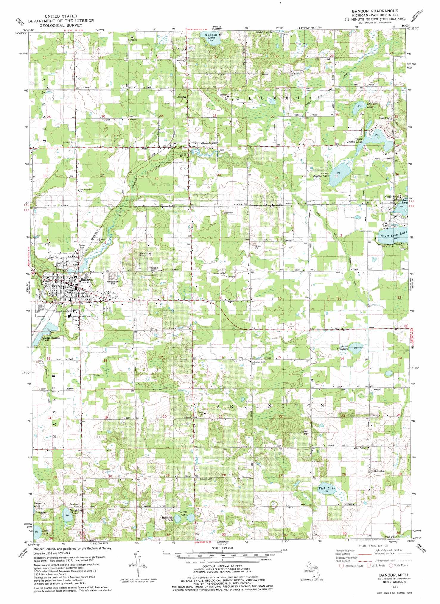
USGS Topo Quad 42086c1 - 1:24,000 scale
| Topo Map Name: | Bangor |
| USGS Topo Quad ID: | 42086c1 |
| Print Size: | ca. 21 1/4" wide x 27" high |
| Southeast Coordinates: | 42.25° N latitude / 86° W longitude |
| Map Center Coordinates: | 42.3125° N latitude / 86.0625° W longitude |
| U.S. State: | MI |
| Filename: | o42086c1.jpg |
| Download Map JPG Image: | Bangor topo map 1:24,000 scale |
| Map Type: | Topographic |
| Topo Series: | 7.5´ |
| Map Scale: | 1:24,000 |
| Source of Map Images: | United States Geological Survey (USGS) |
| Alternate Map Versions: |
Bangor MI 1981, updated 1982 Download PDF Buy paper map Bangor MI 2011 Download PDF Buy paper map Bangor MI 2014 Download PDF Buy paper map Bangor MI 2017 Download PDF Buy paper map |
1:24,000 Topo Quads surrounding Bangor
Glenn |
Fennville |
Millgrove |
Allegan |
|
South Haven |
Lacota |
Pullman |
Bloomingdale |
Merson |
Covert |
Mcdonald |
Bangor |
Gobles West |
Gobles East |
Coloma |
Hartford |
Lawrence |
Paw Paw |
Lawton |
Sodus |
Sister Lakes |
Twin Lakes |
Decatur |
Marcellus |
> Back to 42086a1 at 1:100,000 scale
> Back to 42086a1 at 1:250,000 scale
> Back to U.S. Topo Maps home
Bangor topo map: Gazetteer
Bangor: Canals
Great Bear Lake Drain elevation 213m 698′Bangor: Lakes
Carroll Lake elevation 218m 715′Fisk Lake elevation 233m 764′
Haney Lake elevation 205m 672′
Hillocher Lake elevation 217m 711′
Lake Fourteen elevation 206m 675′
Lower Jeptha Lake elevation 205m 672′
Mill Pond elevation 194m 636′
Munson Lake elevation 215m 705′
North Scott Lake elevation 207m 679′
Scott Lakes elevation 207m 679′
South Scott Lake elevation 207m 679′
Southard Lake elevation 210m 688′
Stillwell Lake elevation 205m 672′
Upper Jeptha Lake elevation 206m 675′
Bangor: Parks
Lions Park elevation 198m 649′Bangor: Populated Places
Bangor elevation 201m 659′Breedsville elevation 202m 662′
Bangor: Post Offices
Arlington Post Office (historical) elevation 241m 790′Bangor Post Office elevation 201m 659′
Breedsville Post Office elevation 201m 659′
Bangor: Streams
Black River Extension Drain elevation 204m 669′Cedar Drain elevation 197m 646′
Lower Jeptha Lake Drain elevation 204m 669′
Maple Creek elevation 192m 629′
Nelson Extension Drain elevation 197m 646′
Bangor digital topo map on disk
Buy this Bangor topo map showing relief, roads, GPS coordinates and other geographical features, as a high-resolution digital map file on DVD:
Northern Illinois, Northern Indiana & Southwestern Michigan
Buy digital topo maps: Northern Illinois, Northern Indiana & Southwestern Michigan