Twin Lakes Topo Map Michigan
To zoom in, hover over the map of Twin Lakes
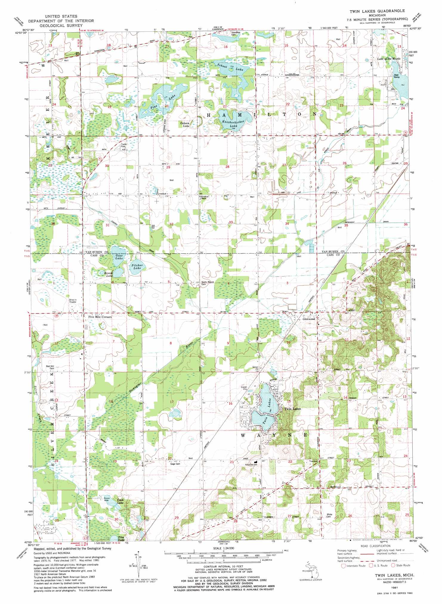
USGS Topo Quad 42086a1 - 1:24,000 scale
| Topo Map Name: | Twin Lakes |
| USGS Topo Quad ID: | 42086a1 |
| Print Size: | ca. 21 1/4" wide x 27" high |
| Southeast Coordinates: | 42° N latitude / 86° W longitude |
| Map Center Coordinates: | 42.0625° N latitude / 86.0625° W longitude |
| U.S. State: | MI |
| Filename: | o42086a1.jpg |
| Download Map JPG Image: | Twin Lakes topo map 1:24,000 scale |
| Map Type: | Topographic |
| Topo Series: | 7.5´ |
| Map Scale: | 1:24,000 |
| Source of Map Images: | United States Geological Survey (USGS) |
| Alternate Map Versions: |
Twin Lakes MI 1981, updated 1982 Download PDF Buy paper map Twin Lakes MI 2011 Download PDF Buy paper map Twin Lakes MI 2014 Download PDF Buy paper map Twin Lakes MI 2017 Download PDF Buy paper map |
1:24,000 Topo Quads surrounding Twin Lakes
Covert |
Mcdonald |
Bangor |
Gobles West |
Gobles East |
Coloma |
Hartford |
Lawrence |
Paw Paw |
Lawton |
Sodus |
Sister Lakes |
Twin Lakes |
Decatur |
Marcellus |
Berrien Springs |
Sumnerville |
Dowagiac |
Vandalia |
Jones |
Niles West |
Niles East |
Edwardsburg |
Adamsville |
Mottville |
> Back to 42086a1 at 1:100,000 scale
> Back to 42086a1 at 1:250,000 scale
> Back to U.S. Topo Maps home
Twin Lakes topo map: Gazetteer
Twin Lakes: Canals
Osborn Drain elevation 231m 757′Twin Lakes: Lakes
Cook Lake elevation 223m 731′Geer Lake elevation 229m 751′
Knickerbocker Lake elevation 234m 767′
Osborn Lake elevation 233m 764′
Pine Lake elevation 235m 770′
Pitcher Lake elevation 229m 751′
Round Lake elevation 229m 751′
School Lake elevation 235m 770′
Twin Lakes elevation 238m 780′
Twin Lakes: Parks
Hamilton Grange Hall Historical Marker elevation 237m 777′Twin Lakes: Populated Places
Five Mile Corners elevation 232m 761′Glenwood elevation 232m 761′
Phelps Mobile Home Park elevation 239m 784′
Twin Lakes elevation 244m 800′
Twin Lakes: Post Offices
Glenwood Post Office (historical) elevation 232m 761′Twin Lakes: Streams
Lake of the Woods Drain elevation 226m 741′Twin Lakes digital topo map on disk
Buy this Twin Lakes topo map showing relief, roads, GPS coordinates and other geographical features, as a high-resolution digital map file on DVD:
Northern Illinois, Northern Indiana & Southwestern Michigan
Buy digital topo maps: Northern Illinois, Northern Indiana & Southwestern Michigan