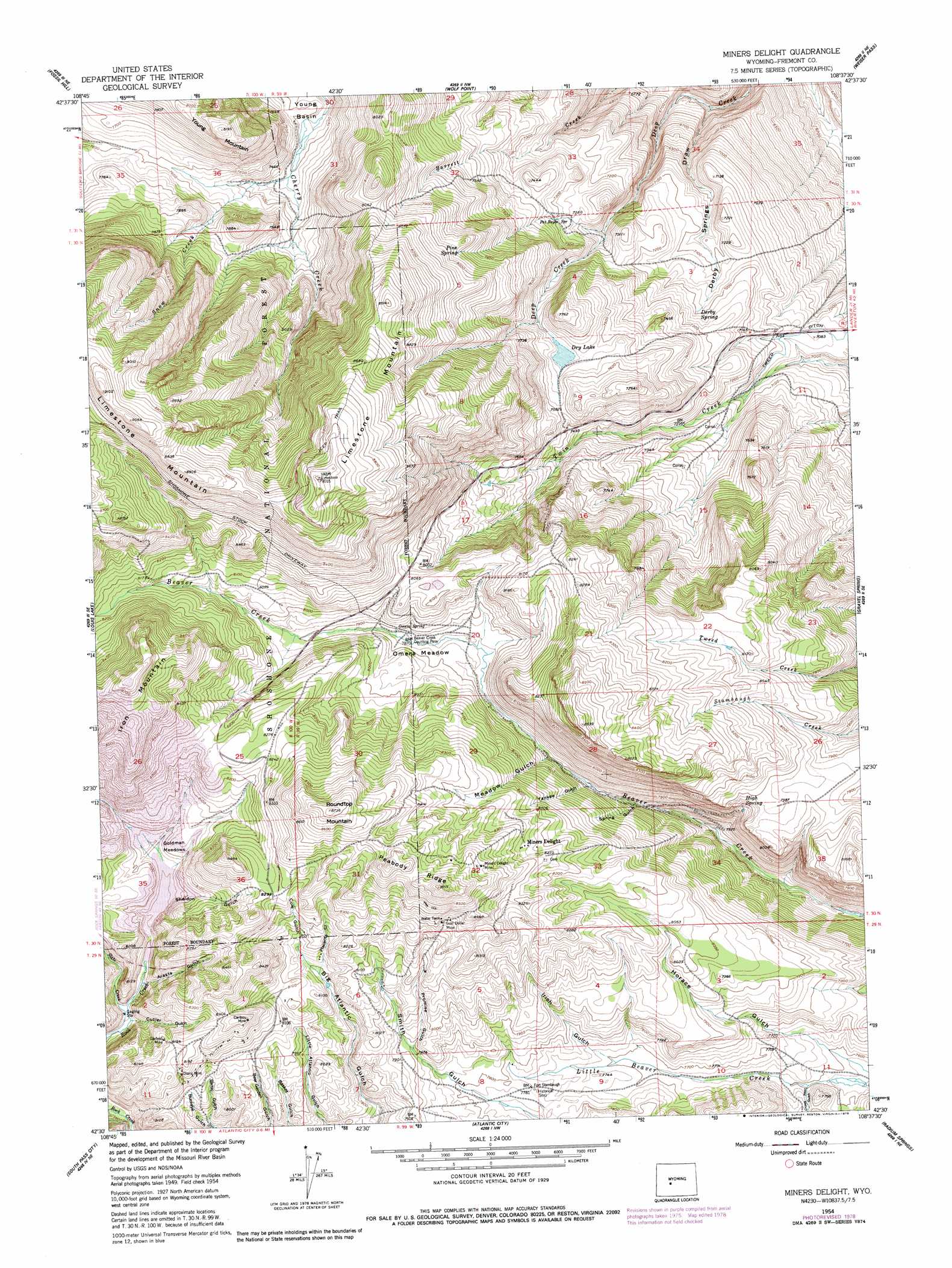
Miners Delight Topo Map Wyoming
To zoom in, hover over the map of Miners Delight
USGS Topo Quad 42108e6 - 1:24,000 scale
| Topo Map Name: | Miners Delight |
| USGS Topo Quad ID: | 42108e6 |
| Print Size: | ca. 21 1/4" wide x 27" high |
| Southeast Coordinates: | 42.5° N latitude / 108.625° W longitude |
| Map Center Coordinates: | 42.5625° N latitude / 108.6875° W longitude |
| U.S. State: | WY |
| Filename: | o42108e6.jpg |
| Download Map JPG Image: | Miners Delight topo map 1:24,000 scale |
| Map Type: | Topographic |
| Topo Series: | 7.5´ |
| Map Scale: | 1:24,000 |
| Source of Map Images: | United States Geological Survey (USGS) |
| Alternate Map Versions: |
Miners Delight WY 1954, updated 1956 Download PDF Buy paper map Miners Delight WY 1954, updated 1961 Download PDF Buy paper map Miners Delight WY 1954, updated 1961 Download PDF Buy paper map Miners Delight WY 1954, updated 1979 Download PDF Buy paper map Miners Delight WY 1991, updated 1997 Download PDF Buy paper map Miners Delight WY 2012 Download PDF Buy paper map Miners Delight WY 2015 Download PDF Buy paper map |
| FStopo: | US Forest Service topo Miners Delight is available: Download FStopo PDF Download FStopo TIF |
1:24,000 Topo Quads surrounding Miners Delight
Mount Arter |
Mount Arter Se |
Lander |
Lander Se |
Ninemile Hill |
Cony Mountain |
Fossil Hill |
Wolf Point |
Weiser Pass |
Del Monte Ridge |
Christina Lake |
Louis Lake |
Miners Delight |
Gravel Spring |
Schoettlin Mountain |
Anderson Ridge |
South Pass City |
Atlantic City |
Radium Springs |
Lewiston Lakes |
Pacific Springs |
Dickie Springs |
Continental Peak |
Circle Bar Lake |
Picket Lake |
> Back to 42108e1 at 1:100,000 scale
> Back to 42108a1 at 1:250,000 scale
> Back to U.S. Topo Maps home
Miners Delight topo map: Gazetteer
Miners Delight: Flats
Goldman Meadows elevation 2439m 8001′Omera Meadow elevation 2403m 7883′
Miners Delight: Lakes
Dry Lake elevation 2292m 7519′Miners Delight: Mines
Caribou Mine elevation 2537m 8323′Columbia Geneva Mines elevation 2602m 8536′
Copper Chief Gold Mine elevation 2537m 8323′
Diana Mine elevation 2474m 8116′
Fire King Deposit elevation 2479m 8133′
Garfield Mine elevation 2503m 8211′
Gold Dollar Mine elevation 2525m 8284′
Midas Mine elevation 2529m 8297′
Miners Delight Mine elevation 2579m 8461′
Red Canyon Rim Mine elevation 2079m 6820′
Rock Creek Mine elevation 2503m 8211′
Miners Delight: Populated Places
Miners Delight elevation 2513m 8244′Miners Delight: Ridges
Peabody Ridge elevation 2613m 8572′Miners Delight: Springs
Derby Spring elevation 2195m 7201′High Spring elevation 2404m 7887′
Omera Spring elevation 2415m 7923′
Pat Royce Spring elevation 2210m 7250′
Pine Spring elevation 2394m 7854′
Miners Delight: Streams
Slate Creek elevation 2403m 7883′Snow Creek elevation 2274m 7460′
Snow Creek elevation 2415m 7923′
Miners Delight: Summits
Limestone Mountain elevation 2652m 8700′Roundtop Mountain elevation 2663m 8736′
Miners Delight: Valleys
Arasta Gulch elevation 2403m 7883′Cole Gulch elevation 2437m 7995′
Crows Nest Gulch elevation 2317m 7601′
Cutler Gulch elevation 2395m 7857′
Derby Springs Draw elevation 1959m 6427′
Horace Gulch elevation 2311m 7582′
Irish Gulch elevation 2347m 7700′
Meadow Gulch elevation 2377m 7798′
Placerita Gulch elevation 2445m 8021′
Promise Gulch elevation 2402m 7880′
Sheldon Gulch elevation 2420m 7939′
Spring Gulch elevation 2329m 7641′
Yankee Gulch elevation 2365m 7759′
Miners Delight digital topo map on disk
Buy this Miners Delight topo map showing relief, roads, GPS coordinates and other geographical features, as a high-resolution digital map file on DVD: