Grand View Peak Topo Map Idaho
To zoom in, hover over the map of Grand View Peak
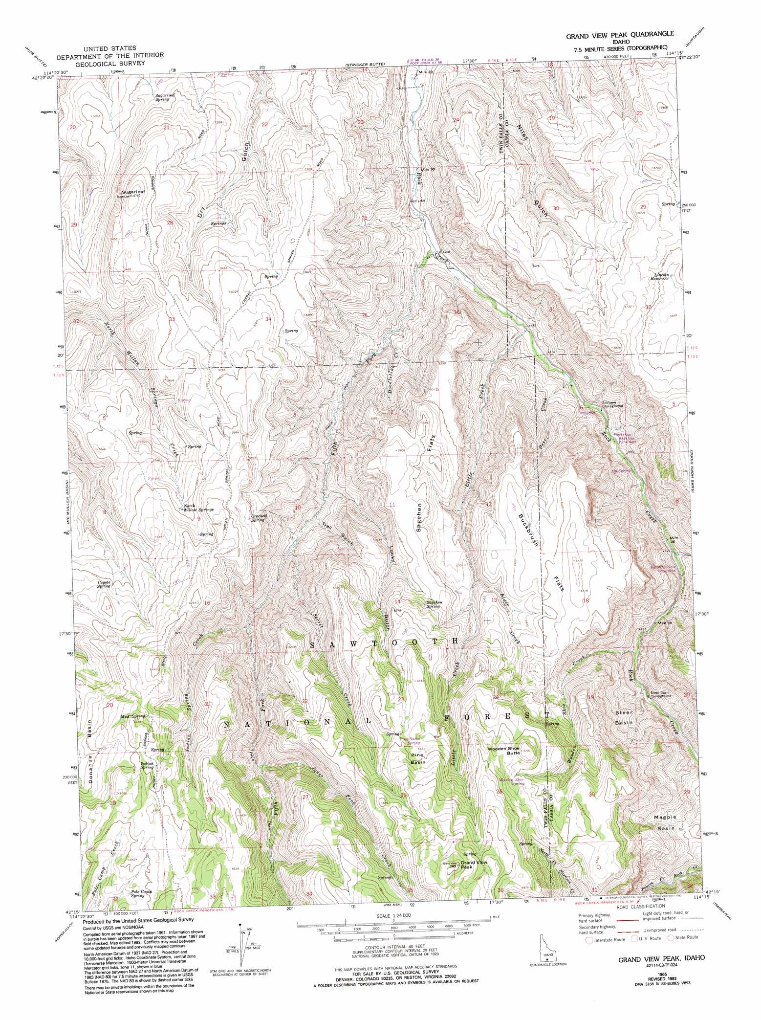
USGS Topo Quad 42114c3 - 1:24,000 scale
| Topo Map Name: | Grand View Peak |
| USGS Topo Quad ID: | 42114c3 |
| Print Size: | ca. 21 1/4" wide x 27" high |
| Southeast Coordinates: | 42.25° N latitude / 114.25° W longitude |
| Map Center Coordinates: | 42.3125° N latitude / 114.3125° W longitude |
| U.S. State: | ID |
| Filename: | o42114c3.jpg |
| Download Map JPG Image: | Grand View Peak topo map 1:24,000 scale |
| Map Type: | Topographic |
| Topo Series: | 7.5´ |
| Map Scale: | 1:24,000 |
| Source of Map Images: | United States Geological Survey (USGS) |
| Alternate Map Versions: |
Grand View Peak ID 1965, updated 1966 Download PDF Buy paper map Grand View Peak ID 1965, updated 1986 Download PDF Buy paper map Grand View Peak ID 1965, updated 1993 Download PDF Buy paper map Grand View Peak ID 2011 Download PDF Buy paper map Grand View Peak ID 2013 Download PDF Buy paper map |
| FStopo: | US Forest Service topo Grand View Peak is available: Download FStopo PDF Download FStopo TIF |
1:24,000 Topo Quads surrounding Grand View Peak
Filer |
Twin Falls |
Kimberly |
Eden |
Milner |
Berger |
Hub Butte |
Stricker Butte |
Murtaugh |
Milner Butte |
Hollister |
Mcmullen Basin |
Grand View Peak |
Rams Horn Ridge |
Buckhorn Canyon |
Rogerson |
Hopper Gulch |
Pike Mountain |
Trapper Peak |
Severe Spring |
Magic Hot Springs |
Big Creek Ranch |
Timber Butte |
Mahogany Butte |
Ibex Peak |
> Back to 42114a1 at 1:100,000 scale
> Back to 42114a1 at 1:250,000 scale
> Back to U.S. Topo Maps home
Grand View Peak topo map: Gazetteer
Grand View Peak: Basins
Donahue Basin elevation 1905m 6250′Magpie Basin elevation 1683m 5521′
Pine Basin elevation 2011m 6597′
Steer Basin elevation 1667m 5469′
Grand View Peak: Flats
Buckbrush Flats elevation 1827m 5994′Sagehen Flats elevation 1761m 5777′
Grand View Peak: Reservoirs
Lincoln Reservoir elevation 1693m 5554′Grand View Peak: Springs
330 Spring elevation 1418m 4652′Coyote Spring elevation 1769m 5803′
Crockett Spring elevation 1790m 5872′
Deadeye Spring elevation 1712m 5616′
Indian Spring elevation 1930m 6332′
Mud Spring elevation 1929m 6328′
North Willow Springs elevation 1757m 5764′
Pine Basin Spring elevation 1985m 6512′
Pole Camp Spring elevation 1929m 6328′
Sagehen Spring elevation 1817m 5961′
Sugarloaf Spring elevation 1559m 5114′
Wooden Shoe Spring elevation 2004m 6574′
Grand View Peak: Streams
Bluff Creek elevation 1703m 5587′Deer Creek elevation 1379m 4524′
Doodlelink Creek elevation 1388m 4553′
Fifth Fork Rock Creek elevation 1342m 4402′
Fourth Fork Rock Creek elevation 1576m 5170′
Harrington Fork elevation 1447m 4747′
Indian Spring Creek elevation 1593m 5226′
Jones Fork Creek elevation 1713m 5620′
Little Creek elevation 1365m 4478′
Secret Creek elevation 1504m 4934′
Wooden Shoe Creek elevation 1495m 4904′
Grand View Peak: Summits
Grand View Peak elevation 2197m 7208′Sugarloaf elevation 1748m 5734′
Wooden Shoe Butte elevation 2066m 6778′
Grand View Peak: Valleys
Lucky Gulch elevation 1492m 4895′Trail Gulch elevation 1486m 4875′
Grand View Peak digital topo map on disk
Buy this Grand View Peak topo map showing relief, roads, GPS coordinates and other geographical features, as a high-resolution digital map file on DVD: