Three Creek Topo Map Idaho
To zoom in, hover over the map of Three Creek
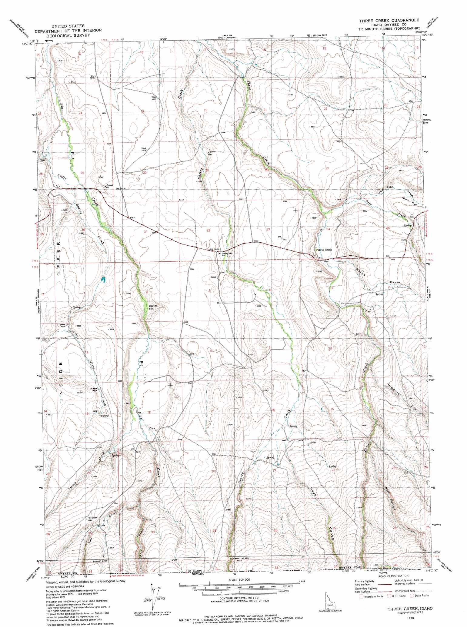
USGS Topo Quad 42115a2 - 1:24,000 scale
| Topo Map Name: | Three Creek |
| USGS Topo Quad ID: | 42115a2 |
| Print Size: | ca. 21 1/4" wide x 27" high |
| Southeast Coordinates: | 42° N latitude / 115.125° W longitude |
| Map Center Coordinates: | 42.0625° N latitude / 115.1875° W longitude |
| U.S. State: | ID |
| Filename: | o42115a2.jpg |
| Download Map JPG Image: | Three Creek topo map 1:24,000 scale |
| Map Type: | Topographic |
| Topo Series: | 7.5´ |
| Map Scale: | 1:24,000 |
| Source of Map Images: | United States Geological Survey (USGS) |
| Alternate Map Versions: |
Three Creek ID 1979, updated 1980 Download PDF Buy paper map Three Creek ID 2010 Download PDF Buy paper map Three Creek ID 2013 Download PDF Buy paper map |
1:24,000 Topo Quads surrounding Three Creek
Clover Butte South |
Juniper Butte |
Coonskin Butte |
Big Bend Crossing |
Roseworth |
Poison Butte |
Mosquito Lake Butte |
Salls Crossing |
Grassy Hills |
Cedar Creek Reservoir |
Dishpan |
Murphy Hot Springs |
Three Creek |
Curtis Draw |
Taylor Canyon |
Jarbidge North |
Robinson Creek |
Caudle Creek |
Elk Mountain |
Bear Mountain |
Jarbidge South |
Gods Pocket Peak |
Goat Creek |
Buckhorn Ridge |
Twin Meadows Ranch |
> Back to 42115a1 at 1:100,000 scale
> Back to 42114a1 at 1:250,000 scale
> Back to U.S. Topo Maps home
Three Creek topo map: Gazetteer
Three Creek: Cliffs
Black Rock elevation 1694m 5557′Castle Rock elevation 1693m 5554′
Three Creek: Flats
Beaver Flat elevation 1655m 5429′Joiner Flat elevation 1636m 5367′
Mud Flat elevation 1709m 5606′
Three Creek: Populated Places
Three Creek elevation 1671m 5482′Three Creek: Streams
Deer Creek elevation 1692m 5551′Deer Creek elevation 1703m 5587′
Flat Creek elevation 1724m 5656′
Flat Creek elevation 1723m 5652′
Hayes Creek elevation 1711m 5613′
Little Spring Creek elevation 1614m 5295′
Pole Creek elevation 1728m 5669′
Pole Creek elevation 1728m 5669′
Ross Pasture Creek elevation 1777m 5830′
Ross Pasture Creek elevation 1753m 5751′
Spring Creek elevation 1675m 5495′
Spring Creek elevation 1675m 5495′
Three Creek: Valleys
Estes Draw elevation 1673m 5488′Hays Canyon elevation 1736m 5695′
Hays Canyon elevation 1797m 5895′
Higgins Draw elevation 1873m 6145′
Mud Flat Draw elevation 1675m 5495′
Three Creek digital topo map on disk
Buy this Three Creek topo map showing relief, roads, GPS coordinates and other geographical features, as a high-resolution digital map file on DVD: