Grasmere Reservoir Topo Map Idaho
To zoom in, hover over the map of Grasmere Reservoir
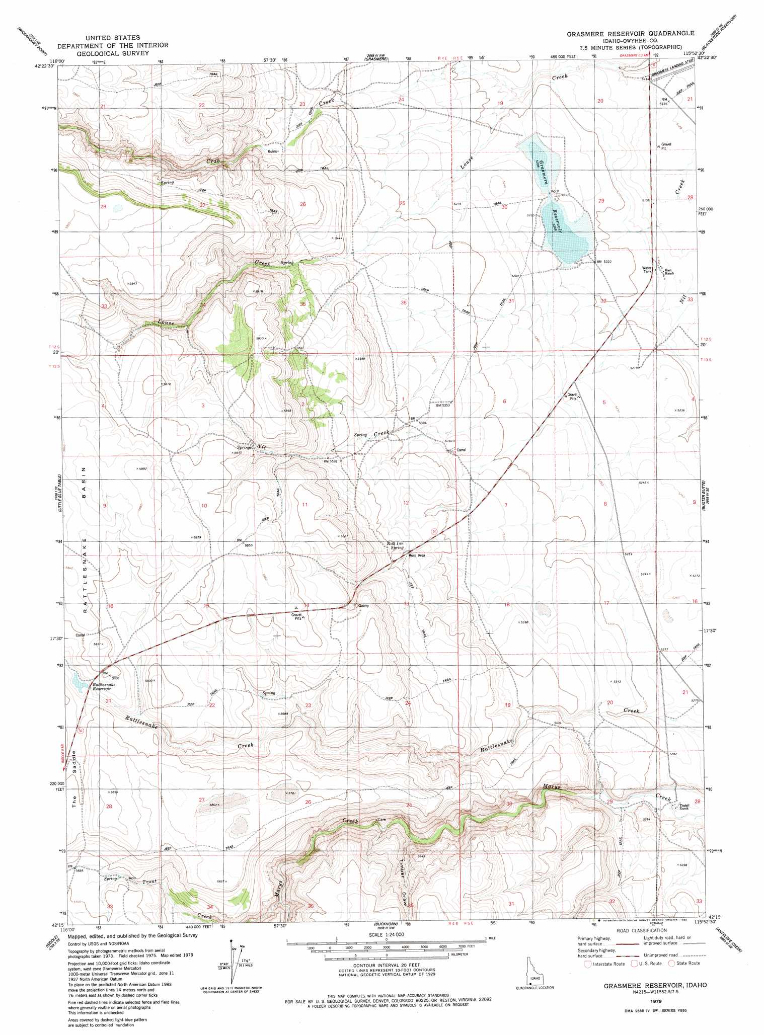
USGS Topo Quad 42115c8 - 1:24,000 scale
| Topo Map Name: | Grasmere Reservoir |
| USGS Topo Quad ID: | 42115c8 |
| Print Size: | ca. 21 1/4" wide x 27" high |
| Southeast Coordinates: | 42.25° N latitude / 115.875° W longitude |
| Map Center Coordinates: | 42.3125° N latitude / 115.9375° W longitude |
| U.S. State: | ID |
| Filename: | o42115c8.jpg |
| Download Map JPG Image: | Grasmere Reservoir topo map 1:24,000 scale |
| Map Type: | Topographic |
| Topo Series: | 7.5´ |
| Map Scale: | 1:24,000 |
| Source of Map Images: | United States Geological Survey (USGS) |
| Alternate Map Versions: |
Grasmere Reservoir ID 1979, updated 1980 Download PDF Buy paper map Grasmere Reservoir ID 2010 Download PDF Buy paper map Grasmere Reservoir ID 2013 Download PDF Buy paper map |
1:24,000 Topo Quads surrounding Grasmere Reservoir
Sugarloaf |
Hill Pasture |
Wickahoney Crossing |
Table Butte |
Austin Butte |
Turner Table |
Wickahoney Point |
Grasmere |
Blackstone Reservoir |
Cave Draw |
Nichol Flat |
Little Blue Table |
Grasmere Reservoir |
Buster Butte |
Indian Hot Springs |
Flying H Ranch |
Riddle |
Buckhorn |
Antelope Creek |
Triguero Lake |
Mountain View Lake |
Three Forks |
Indian Hay Meadows |
Black Leg Creek |
Triplet Butte |
> Back to 42115a1 at 1:100,000 scale
> Back to 42114a1 at 1:250,000 scale
> Back to U.S. Topo Maps home
Grasmere Reservoir topo map: Gazetteer
Grasmere Reservoir: Airports
Grasmere Airport elevation 1561m 5121′Grasmere Reservoir: Basins
Rattlesnake Basin elevation 1779m 5836′Grasmere Reservoir: Dams
Grasmere Dam elevation 1592m 5223′Rattlesnake Creek Dam elevation 1750m 5741′
Grasmere Reservoir: Populated Places
Tindall (historical) elevation 1569m 5147′Grasmere Reservoir: Reservoirs
Grasmere Reservoir elevation 1592m 5223′Rattlesnake Reservoir elevation 1750m 5741′
Grasmere Reservoir: Springs
Roll Inn Spring elevation 1671m 5482′Grasmere Reservoir: Streams
China Creek elevation 1561m 5121′Crab Creek elevation 1573m 5160′
Heifer Springs Creek elevation 1688m 5538′
Nanny Creek elevation 1594m 5229′
Trout Creek elevation 1646m 5400′
Grasmere Reservoir: Valleys
Timber Draw elevation 1616m 5301′Grasmere Reservoir digital topo map on disk
Buy this Grasmere Reservoir topo map showing relief, roads, GPS coordinates and other geographical features, as a high-resolution digital map file on DVD: