Black Leg Creek Topo Map Idaho
To zoom in, hover over the map of Black Leg Creek
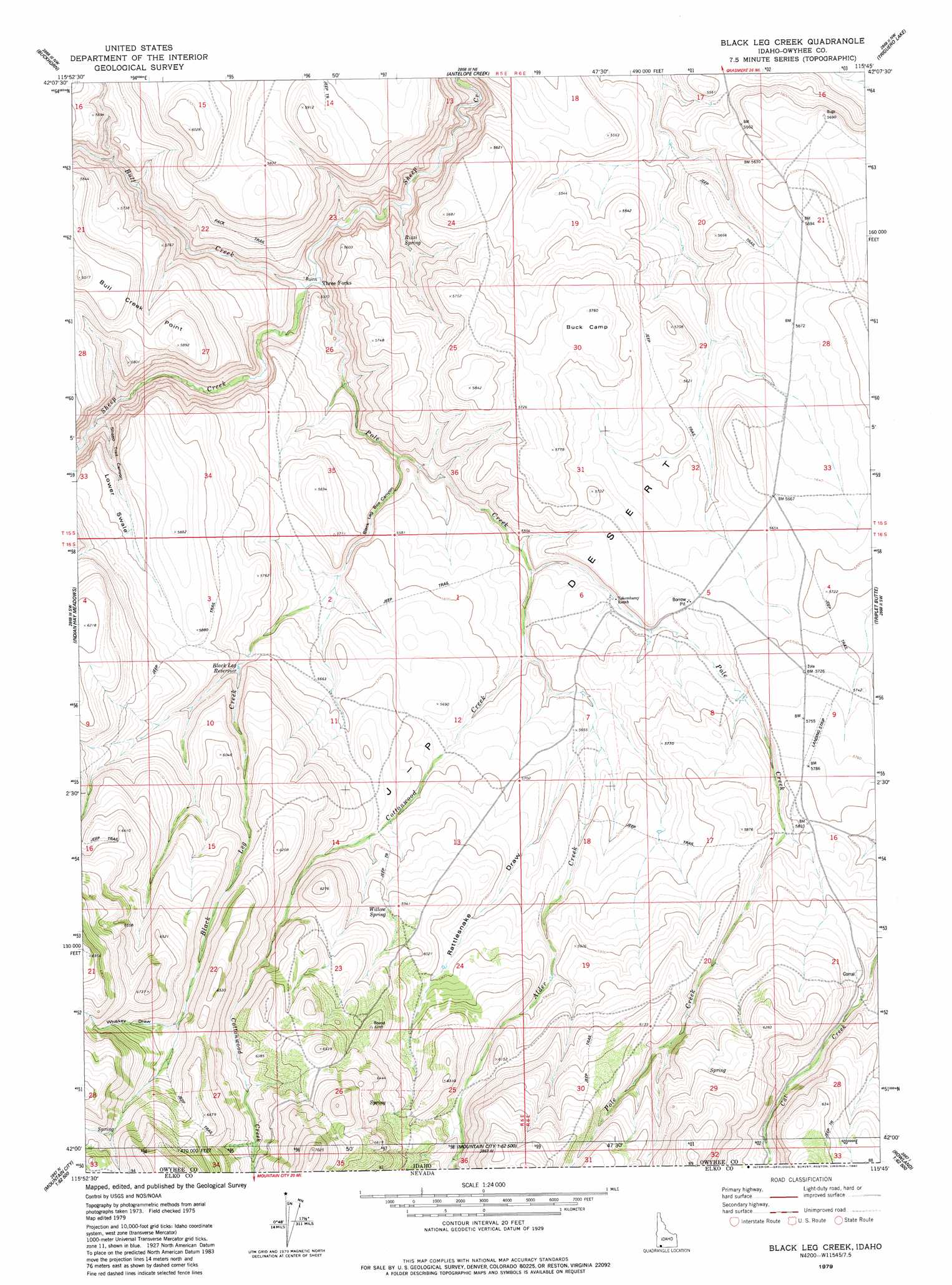
USGS Topo Quad 42115a7 - 1:24,000 scale
| Topo Map Name: | Black Leg Creek |
| USGS Topo Quad ID: | 42115a7 |
| Print Size: | ca. 21 1/4" wide x 27" high |
| Southeast Coordinates: | 42° N latitude / 115.75° W longitude |
| Map Center Coordinates: | 42.0625° N latitude / 115.8125° W longitude |
| U.S. State: | ID |
| Filename: | o42115a7.jpg |
| Download Map JPG Image: | Black Leg Creek topo map 1:24,000 scale |
| Map Type: | Topographic |
| Topo Series: | 7.5´ |
| Map Scale: | 1:24,000 |
| Source of Map Images: | United States Geological Survey (USGS) |
| Alternate Map Versions: |
Black Leg Creek ID 1979, updated 1980 Download PDF Buy paper map Black Leg Creek ID 2010 Download PDF Buy paper map Black Leg Creek ID 2013 Download PDF Buy paper map |
1:24,000 Topo Quads surrounding Black Leg Creek
Little Blue Table |
Grasmere Reservoir |
Buster Butte |
Indian Hot Springs |
Inside Lakes |
Riddle |
Buckhorn |
Antelope Creek |
Triguero Lake |
The Arch |
Three Forks |
Indian Hay Meadows |
Black Leg Creek |
Triplet Butte |
Cowan Reservoir |
Owyhee |
Winter Ridge |
Hicks Mountain |
Big Table |
Bearpaw Mountain |
Ungina Wongo |
Mountain City |
Merritt Mountain |
Tennessee Mountain |
Coon Creek |
> Back to 42115a1 at 1:100,000 scale
> Back to 42114a1 at 1:250,000 scale
> Back to U.S. Topo Maps home
Black Leg Creek topo map: Gazetteer
Black Leg Creek: Dams
Billings Dam elevation 1729m 5672′Black Leg Creek: Reservoirs
Billings Reservoir elevation 1729m 5672′Black Leg Reservoir elevation 1730m 5675′
Black Leg Creek: Springs
Rizzi Spring elevation 1606m 5269′Willow Spring elevation 1807m 5928′
Black Leg Creek: Streams
Alder Creek elevation 1688m 5538′Alder Creek elevation 1688m 5538′
Black Leg Creek elevation 1633m 5357′
Bull Creek elevation 1580m 5183′
Cottonwood Creek elevation 1672m 5485′
Cottonwood Creek elevation 1672m 5485′
Pole Creek elevation 1580m 5183′
Pole Creek elevation 1580m 5183′
Black Leg Creek: Summits
Bull Creek Point elevation 1828m 5997′Black Leg Creek: Valleys
Black Leg Box Canyon elevation 1633m 5357′Lower Swale elevation 1622m 5321′
Rattlesnake Draw elevation 1715m 5626′
Sheep Trail Canyon elevation 1616m 5301′
Upper Swale elevation 1776m 5826′
Whiskey Draw elevation 1922m 6305′
Black Leg Creek digital topo map on disk
Buy this Black Leg Creek topo map showing relief, roads, GPS coordinates and other geographical features, as a high-resolution digital map file on DVD: