Crooked Creek Valley Topo Map Oregon
To zoom in, hover over the map of Crooked Creek Valley
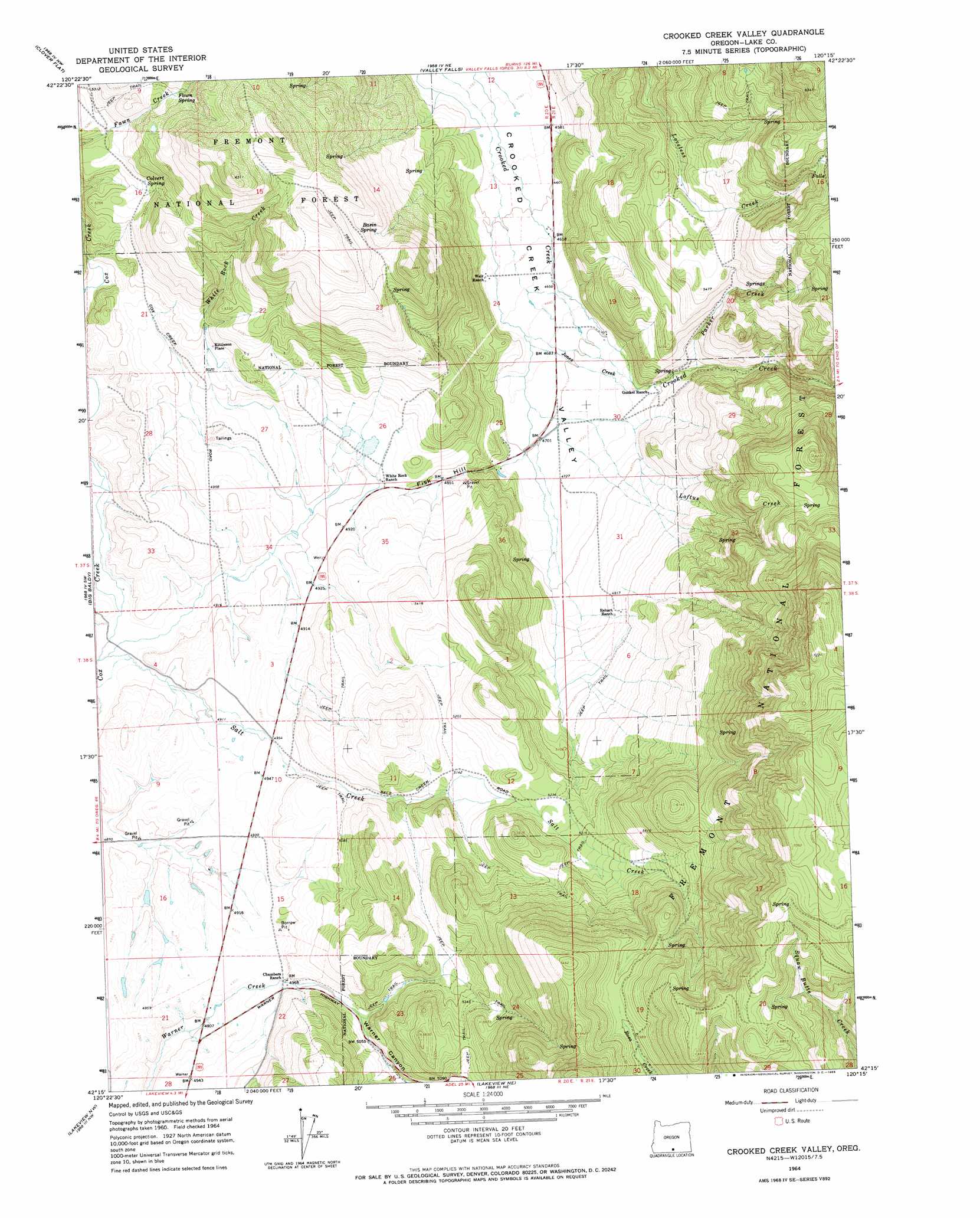
USGS Topo Quad 42120c3 - 1:24,000 scale
| Topo Map Name: | Crooked Creek Valley |
| USGS Topo Quad ID: | 42120c3 |
| Print Size: | ca. 21 1/4" wide x 27" high |
| Southeast Coordinates: | 42.25° N latitude / 120.25° W longitude |
| Map Center Coordinates: | 42.3125° N latitude / 120.3125° W longitude |
| U.S. State: | OR |
| Filename: | o42120c3.jpg |
| Download Map JPG Image: | Crooked Creek Valley topo map 1:24,000 scale |
| Map Type: | Topographic |
| Topo Series: | 7.5´ |
| Map Scale: | 1:24,000 |
| Source of Map Images: | United States Geological Survey (USGS) |
| Alternate Map Versions: |
Crooked Creek Valley OR 1964, updated 1965 Download PDF Buy paper map Crooked Creek Valley OR 2004, updated 2007 Download PDF Buy paper map Crooked Creek Valley OR 2011 Download PDF Buy paper map Crooked Creek Valley OR 2014 Download PDF Buy paper map |
| FStopo: | US Forest Service topo Crooked Creek Valley is available: Download FStopo PDF Download FStopo TIF |
1:24,000 Topo Quads surrounding Crooked Creek Valley
Morgan Butte |
Tucker Hill |
Coglan Buttes Se |
Lake Abert South |
Cooper Draw |
Shoestring Butte |
Clover Flat |
Valley Falls |
Little Honey Creek |
Drake Peak Ne |
Cox Flat |
Big Baldy |
Crooked Creek Valley |
Crook Peak |
Drake Peak |
Drews Gap |
Lakeview Airport |
Lakeview |
Horse Prairie |
Sage Hen Butte |
Fitzwater Point |
West Side |
Crane Creek |
Crane Mountain |
Collins Rim |
> Back to 42120a1 at 1:100,000 scale
> Back to 42120a1 at 1:250,000 scale
> Back to U.S. Topo Maps home
Crooked Creek Valley topo map: Gazetteer
Crooked Creek Valley: Canals
Rehart-Salt Creek Ditch elevation 1456m 4776′Wilcox Ditch elevation 1509m 4950′
Wilson Ditch elevation 1489m 4885′
Crooked Creek Valley: Dams
White Rock Dam elevation 1501m 4924′Crooked Creek Valley: Post Offices
Antler Post Office (historical) elevation 1429m 4688′Crooked Creek Valley: Reservoirs
Cory Reservoir elevation 1442m 4730′Lower Reservoir elevation 1567m 5141′
Upper Reservoir elevation 1572m 5157′
White Rock Reservoirs elevation 1507m 4944′
Crooked Creek Valley: Springs
Basin Spring elevation 1683m 5521′Colvert Spring elevation 1603m 5259′
Fawn Spring elevation 1673m 5488′
Crooked Creek Valley: Streams
Jones Creek elevation 1422m 4665′Little Cove Creek elevation 1587m 5206′
Loftus Creek elevation 1430m 4691′
Parker Creek elevation 1485m 4872′
Crooked Creek Valley: Summits
Fisk Hill elevation 1479m 4852′Crooked Creek Valley digital topo map on disk
Buy this Crooked Creek Valley topo map showing relief, roads, GPS coordinates and other geographical features, as a high-resolution digital map file on DVD: