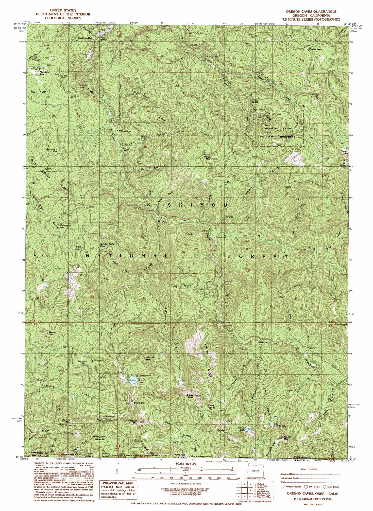
Oregon Caves Topo Map Oregon
To zoom in, hover over the map of Oregon Caves
USGS Topo Quad 42123a4 - 1:24,000 scale
| Topo Map Name: | Oregon Caves |
| USGS Topo Quad ID: | 42123a4 |
| Print Size: | ca. 21 1/4" wide x 27" high |
| Southeast Coordinates: | 42° N latitude / 123.375° W longitude |
| Map Center Coordinates: | 42.0625° N latitude / 123.4375° W longitude |
| U.S. States: | OR, CA |
| Filename: | o42123a4.jpg |
| Download Map JPG Image: | Oregon Caves topo map 1:24,000 scale |
| Map Type: | Topographic |
| Topo Series: | 7.5´ |
| Map Scale: | 1:24,000 |
| Source of Map Images: | United States Geological Survey (USGS) |
| Alternate Map Versions: |
Oregon Caves OR 1986, updated 1986 Download PDF Buy paper map Oregon Caves OR 1996, updated 1999 Download PDF Buy paper map Oregon Caves OR 2011 Download PDF Buy paper map Oregon Caves OR 2014 Download PDF Buy paper map |
| FStopo: | US Forest Service topo Oregon Caves is available: Download FStopo PDF Download FStopo TIF |
1:24,000 Topo Quads surrounding Oregon Caves
Eight Dollar Mountain |
Selma |
Murphy Mountain |
Murphy |
Applegate |
Cave Junction |
Holland |
Kerby Peak |
Williams |
Tallowbox Mountain |
O'Brien |
Takilma |
Oregon Caves |
Grayback Mountain |
Carberry Creek |
Broken Rib Mountain |
Polar Bear Mountain |
Deadman Point |
Figurehead Mountain |
Kangaroo Mountain |
Devils Punchbowl |
Preston Peak |
Happy Camp |
Slater Butte |
Seiad Valley |
> Back to 42123a1 at 1:100,000 scale
> Back to 42122a1 at 1:250,000 scale
> Back to U.S. Topo Maps home
Oregon Caves topo map: Gazetteer
Oregon Caves: Dams
Bolan Lake Dam elevation 1655m 5429′Oregon Caves: Flats
Green Creek Meadow elevation 1495m 4904′Portuguese Flat elevation 1564m 5131′
Serpentine Flat elevation 979m 3211′
Oregon Caves: Gaps
Kings Saddle elevation 1685m 5528′Sundown Gap elevation 1747m 5731′
Oregon Caves: Lakes
Bolan Lake elevation 1639m 5377′East Tanner Lake elevation 1619m 5311′
Tanner Lake elevation 1544m 5065′
Tanner Lakes elevation 1675m 5495′
Oregon Caves: Mines
Blanket Ledge Mine elevation 1640m 5380′Bolan Creek Mine elevation 749m 2457′
Bolan Mine elevation 1201m 3940′
Edmonds Mine elevation 661m 2168′
Grizzly Mine elevation 936m 3070′
Gypsy Queen Mine elevation 1072m 3517′
Kester Mine elevation 811m 2660′
Lucky Strike Mine elevation 1656m 5433′
Luethye Mine elevation 1129m 3704′
Rainbow Mine elevation 742m 2434′
Tip Top Mine elevation 915m 3001′
Yeager Mine elevation 639m 2096′
Oregon Caves: Parks
Oregon Caves National Monument elevation 1334m 4376′Oregon Caves: Populated Places
California Bar elevation 612m 2007′Oregon Caves: Post Offices
Oregon Caves Post Office (historical) elevation 1124m 3687′Oregon Caves: Ridges
Thompson Ridge elevation 1869m 6131′Weston Ridge elevation 1625m 5331′
Oregon Caves: Springs
Cold Spring elevation 1376m 4514′Tiger Springs elevation 604m 1981′
Willow Spring elevation 1176m 3858′
Oregon Caves: Streams
Bolan Creek elevation 747m 2450′Brush Creek elevation 1096m 3595′
Cohen Creek elevation 670m 2198′
Deadhorse Creek elevation 1043m 3421′
Deep Creek elevation 995m 3264′
East Fork Bolan Creek elevation 881m 2890′
East Tanner Creek elevation 1143m 3750′
Elkhorn Creek elevation 781m 2562′
Gold Dollar Creek elevation 710m 2329′
Jackass Creek elevation 723m 2372′
Lake Creek elevation 892m 2926′
Left Fork Sucker Creek elevation 817m 2680′
Left Hand Fork Brush Creek elevation 1243m 4078′
Limestone Creek elevation 817m 2680′
Matz Draw elevation 1492m 4895′
Mule Creek elevation 686m 2250′
No Name Creek elevation 1083m 3553′
Panther Creek elevation 1089m 3572′
Tanner Creek elevation 1047m 3435′
Thirteenmile Creek elevation 1219m 3999′
Yeager Creek elevation 638m 2093′
Yew Creek elevation 1113m 3651′
Oregon Caves: Summits
Althouse Mountain elevation 1885m 6184′Bolan Mountain elevation 1842m 6043′
French Peak elevation 1673m 5488′
Grizzly Peak elevation 1785m 5856′
Horse Mountain elevation 1585m 5200′
Number Eight Peak elevation 1446m 4744′
Tanner Mountain elevation 1906m 6253′
Weston Mountain elevation 1719m 5639′
Whiskers Peak elevation 1776m 5826′
Oregon Caves: Trails
Althouse Trail elevation 1521m 4990′Bolan Lake Trail elevation 1552m 5091′
Boundary Trail elevation 1675m 5495′
Cliff Nature Trail elevation 1217m 3992′
East Fork Sucker Creek Trail elevation 968m 3175′
Gilmore Cutoff Trail elevation 1485m 4872′
Lake Mountain Trail elevation 1718m 5636′
Limestone Trail elevation 1432m 4698′
Sucker Creek Trail elevation 1151m 3776′
Tannen Lakes Trail elevation 1610m 5282′
Oregon Caves: Valleys
Brushy Gulch elevation 606m 1988′Carr Gulch elevation 661m 2168′
Fehley Gulch elevation 1218m 3996′
French Gulch elevation 891m 2923′
Goldsby Gulch elevation 1176m 3858′
Grizzly Gulch elevation 1026m 3366′
Iron Gulch elevation 1232m 4041′
Johnson Gulch elevation 625m 2050′
Julian Gulch elevation 1217m 3992′
Layman Gulch elevation 907m 2975′
Onion Gulch elevation 1315m 4314′
Oregon Caves digital topo map on disk
Buy this Oregon Caves topo map showing relief, roads, GPS coordinates and other geographical features, as a high-resolution digital map file on DVD: