Skeleton Mountain Topo Map Oregon
To zoom in, hover over the map of Skeleton Mountain
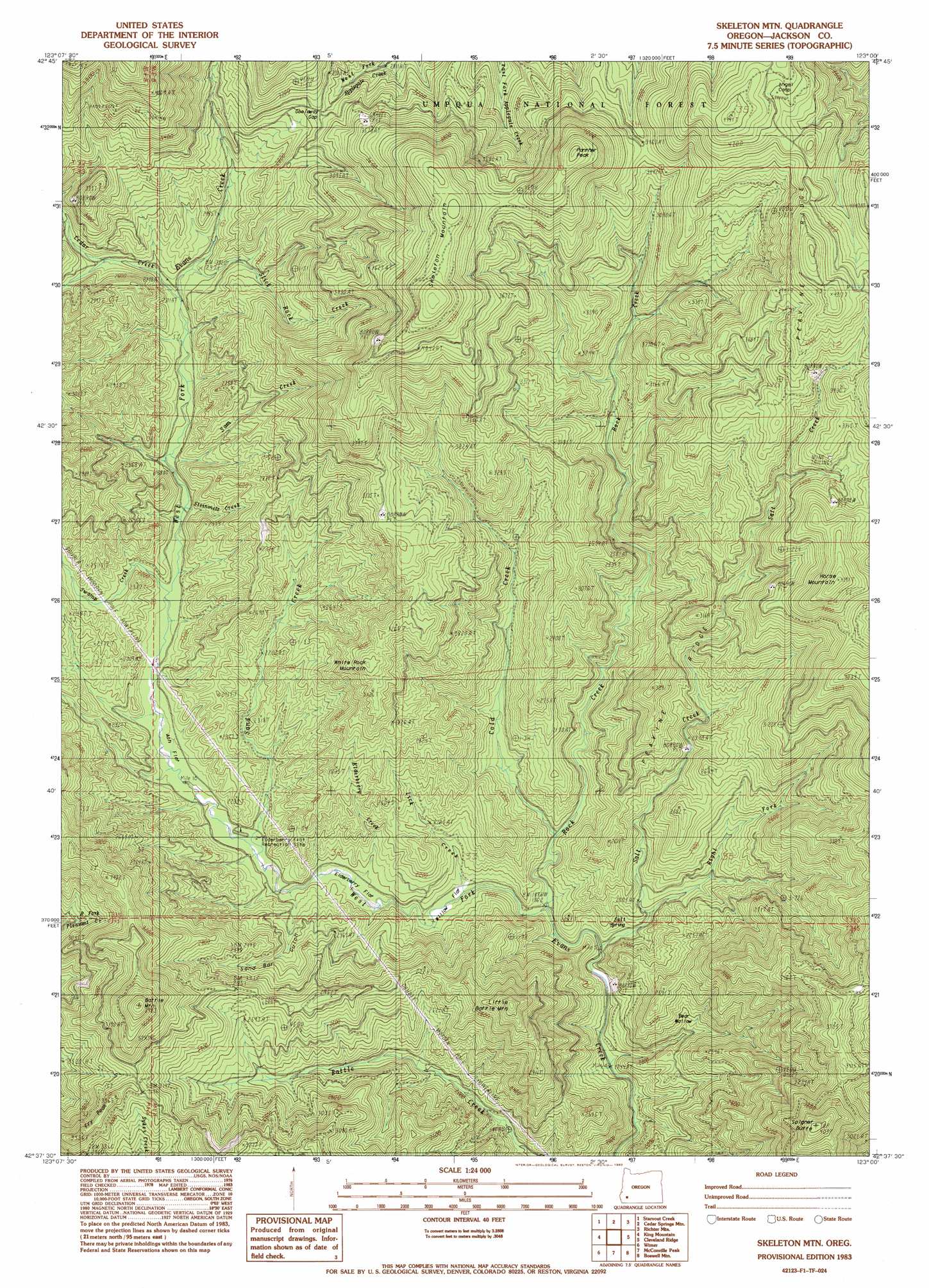
USGS Topo Quad 42123f1 - 1:24,000 scale
| Topo Map Name: | Skeleton Mountain |
| USGS Topo Quad ID: | 42123f1 |
| Print Size: | ca. 21 1/4" wide x 27" high |
| Southeast Coordinates: | 42.625° N latitude / 123° W longitude |
| Map Center Coordinates: | 42.6875° N latitude / 123.0625° W longitude |
| U.S. State: | OR |
| Filename: | o42123f1.jpg |
| Download Map JPG Image: | Skeleton Mountain topo map 1:24,000 scale |
| Map Type: | Topographic |
| Topo Series: | 7.5´ |
| Map Scale: | 1:24,000 |
| Source of Map Images: | United States Geological Survey (USGS) |
| Alternate Map Versions: |
Skeleton Mtn OR 1983, updated 1983 Download PDF Buy paper map Skeleton Mountain OR 1998, updated 2000 Download PDF Buy paper map Skeleton Mountain OR 2011 Download PDF Buy paper map Skeleton Mountain OR 2014 Download PDF Buy paper map |
| FStopo: | US Forest Service topo Skeleton Mountain is available: Download FStopo PDF Download FStopo TIF |
1:24,000 Topo Quads surrounding Skeleton Mountain
Canyonville |
Days Creek |
Milo |
Tiller |
Pickett Butte |
Quines Creek |
Starvout Creek |
Cedar Springs Mountain |
Richter Mountain |
Ragsdale Butte |
Golden |
King Mountain |
Skeleton Mountain |
Cleveland Ridge |
Trail |
Sexton Mountain |
Wimer |
Mcconville Peak |
Boswell Mountain |
Shady Cove |
Grants Pass |
Rogue River |
Gold Hill |
Sams Valley |
Eagle Point |
> Back to 42123e1 at 1:100,000 scale
> Back to 42122a1 at 1:250,000 scale
> Back to U.S. Topo Maps home
Skeleton Mountain topo map: Gazetteer
Skeleton Mountain: Basins
Bear Wallow elevation 621m 2037′Skeleton Mountain: Flats
Ash Flat elevation 617m 2024′Elderberry Flat elevation 611m 2004′
Willow Flat elevation 589m 1932′
Skeleton Mountain: Gaps
Goolaway Gap elevation 927m 3041′Skeleton Mountain: Parks
Salt Creek Recreation Site (historical) elevation 569m 1866′Skeleton Mountain: Ridges
Fry Peak elevation 1005m 3297′Peavine Ridge elevation 969m 3179′
Skeleton Mountain: Springs
Salt Spring elevation 572m 1876′Skeleton Mountain: Streams
Cedar Creek elevation 701m 2299′Cold Creek elevation 592m 1942′
Elderberry Creek elevation 588m 1929′
Lick Creek elevation 576m 1889′
Right Fork Salt Creek elevation 591m 1938′
Rock Creek elevation 562m 1843′
Salt Creek elevation 548m 1797′
Sam Creek elevation 662m 2171′
Sand Creek elevation 606m 1988′
Slick Rock Creek elevation 713m 2339′
Steinmetz Creek elevation 653m 2142′
Swamp Creek elevation 629m 2063′
Skeleton Mountain: Summits
Battle Mountain elevation 1212m 3976′Horse Mountain elevation 1270m 4166′
Little Battle Mountain elevation 1013m 3323′
Panther Peak elevation 1331m 4366′
Skeleton Mountain elevation 1344m 4409′
Spignet Butte elevation 1226m 4022′
White Rock Mountain elevation 987m 3238′
Skeleton Mountain: Valleys
Sand Bar Gulch elevation 629m 2063′Skeleton Mountain digital topo map on disk
Buy this Skeleton Mountain topo map showing relief, roads, GPS coordinates and other geographical features, as a high-resolution digital map file on DVD: