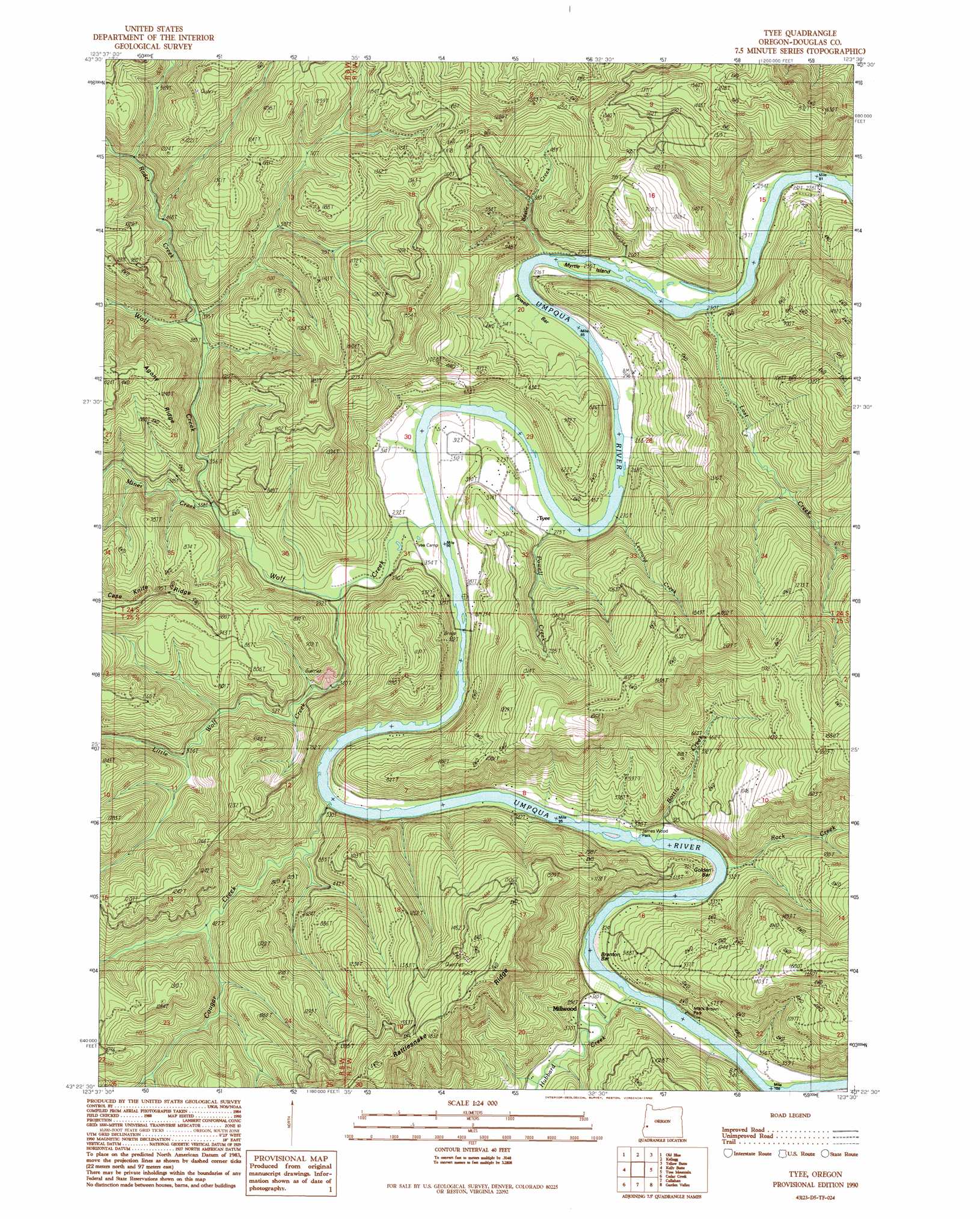
Tyee Topo Map Oregon
To zoom in, hover over the map of Tyee
USGS Topo Quad 43123d5 - 1:24,000 scale
| Topo Map Name: | Tyee |
| USGS Topo Quad ID: | 43123d5 |
| Print Size: | ca. 21 1/4" wide x 27" high |
| Southeast Coordinates: | 43.375° N latitude / 123.5° W longitude |
| Map Center Coordinates: | 43.4375° N latitude / 123.5625° W longitude |
| U.S. State: | OR |
| Filename: | o43123d5.jpg |
| Download Map JPG Image: | Tyee topo map 1:24,000 scale |
| Map Type: | Topographic |
| Topo Series: | 7.5´ |
| Map Scale: | 1:24,000 |
| Source of Map Images: | United States Geological Survey (USGS) |
| Alternate Map Versions: |
Tyee OR 1990, updated 1990 Download PDF Buy paper map Tyee OR 2011 Download PDF Buy paper map Tyee OR 2014 Download PDF Buy paper map |
1:24,000 Topo Quads surrounding Tyee
Scottsburg |
Devils Graveyard |
Elkton |
Putnam Valley |
Drain |
Loon Lake |
Old Blue |
Kellogg |
Yellow Butte |
Yoncalla |
Ivers Peak |
Kelly Butte |
Tyee |
Tyee Mountain |
Sutherlin |
Tioga |
Cedar Creek |
Callahan |
Garden Valley |
Winchester |
Sitkum |
Mount Gurney |
Reston |
Roseburg West |
Roseburg East |
> Back to 43123a1 at 1:100,000 scale
> Back to 43122a1 at 1:250,000 scale
> Back to U.S. Topo Maps home
Tyee topo map: Gazetteer
Tyee: Bars
Branton Bar elevation 101m 331′Powell Bar elevation 80m 262′
Tyee: Bends
Baskett Point elevation 82m 269′Tyee: Islands
Myrtle Island elevation 80m 262′Tyee: Parks
James Wood Park elevation 92m 301′Mack Brown Park elevation 104m 341′
Tyee: Populated Places
Millwood elevation 113m 370′Tyee elevation 90m 295′
Tyee: Post Offices
Millwood Post Office (historical) elevation 113m 370′Tyee Post Office (historical) elevation 90m 295′
Tyee: Reservoirs
Beaver Pond elevation 387m 1269′Rinaldi Reservoir elevation 110m 360′
Tyee: Ridges
Rattlesnake Ridge elevation 603m 1978′Tyee: Streams
Basin Creek elevation 74m 242′Bottle Creek elevation 91m 298′
Cougar Creek elevation 82m 269′
Hubbard Creek elevation 90m 295′
Jack Canyon Creek elevation 172m 564′
Leonard Creek elevation 80m 262′
Little Wolf Creek elevation 111m 364′
Lost Creek elevation 69m 226′
Miner Creek elevation 117m 383′
Porter Creek elevation 87m 285′
Powell Creek elevation 84m 275′
Rader Creek elevation 187m 613′
Rock Creek elevation 86m 282′
Rock Creek elevation 87m 285′
Steve Creek elevation 126m 413′
Wolf Creek elevation 84m 275′
Tyee digital topo map on disk
Buy this Tyee topo map showing relief, roads, GPS coordinates and other geographical features, as a high-resolution digital map file on DVD: