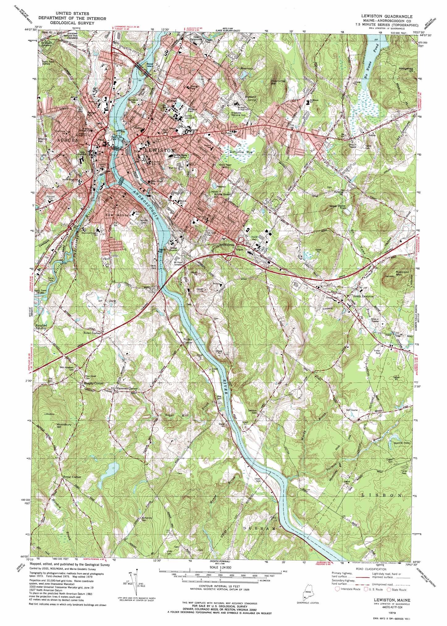
Lewiston Topo Map Maine
To zoom in, hover over the map of Lewiston
USGS Topo Quad 44070a2 - 1:24,000 scale
| Topo Map Name: | Lewiston |
| USGS Topo Quad ID: | 44070a2 |
| Print Size: | ca. 21 1/4" wide x 27" high |
| Southeast Coordinates: | 44° N latitude / 70.125° W longitude |
| Map Center Coordinates: | 44.0625° N latitude / 70.1875° W longitude |
| U.S. State: | ME |
| Filename: | o44070a2.jpg |
| Download Map JPG Image: | Lewiston topo map 1:24,000 scale |
| Map Type: | Topographic |
| Topo Series: | 7.5´ |
| Map Scale: | 1:24,000 |
| Source of Map Images: | United States Geological Survey (USGS) |
| Alternate Map Versions: |
Lewiston ME 1979, updated 1979 Download PDF Buy paper map Lewiston ME 1979, updated 1989 Download PDF Buy paper map Lewiston ME 2011 Download PDF Buy paper map Lewiston ME 2014 Download PDF Buy paper map |
1:24,000 Topo Quads surrounding Lewiston
West Sumner |
Buckfield |
Turner Center |
Wayne |
Winthrop |
Oxford |
Lake Auburn West |
Lake Auburn East |
Monmouth |
Purgatory |
Mechanic Falls |
Minot |
Lewiston |
Lisbon Falls North |
Bowdoinham |
Raymond |
Gray |
North Pownal |
Lisbon Falls South |
Brunswick |
North Windham |
Cumberland Center |
Yarmouth |
Freeport |
Orrs Island |
> Back to 44070a1 at 1:100,000 scale
> Back to 44070a1 at 1:250,000 scale
> Back to U.S. Topo Maps home
Lewiston topo map: Gazetteer
Lewiston: Bridges
North Bridge elevation 36m 118′South Bridge elevation 36m 118′
Vietnam Veterans Memorial Bridge elevation 66m 216′
Lewiston: Crossings
Interchange 13 elevation 70m 229′Lewiston: Dams
Barker Mill Dam elevation 36m 118′Canal Street Dam elevation 39m 127′
Lewiston Falls Dam elevation 44m 144′
Lewiston Falls Project Dam elevation 48m 157′
Taylor Brook Dam elevation 66m 216′
Lewiston: Falls
Great Falls elevation 36m 118′Lewiston: Islands
Boxer Island elevation 51m 167′Fox Island elevation 51m 167′
Lewiston: Lakes
Lake Andrews elevation 72m 236′No Name Pond elevation 72m 236′
Lewiston: Parks
Cedar Street Park elevation 39m 127′Elliot Little League Ball Fields elevation 70m 229′
Franklin Pasture elevation 61m 200′
Gracelon Field elevation 76m 249′
Heritage Park elevation 39m 127′
Kennedy Park elevation 63m 206′
Lakeview Fields elevation 102m 334′
Lewiston Athletic Park elevation 75m 246′
Lewiston-Auburn Railroad Park elevation 40m 131′
Lincoln Street Park elevation 44m 144′
Lower Lisbon Street Historic District elevation 55m 180′
Main Street Historic District elevation 54m 177′
Maple Street Park elevation 53m 173′
Marcotte Park Playground-Ball Field elevation 76m 249′
Moulton Park elevation 44m 144′
Pettingill Park elevation 59m 193′
Pierce Street Playground elevation 56m 183′
Pulsifer Field elevation 80m 262′
Randall Road Ball Fields elevation 60m 196′
Raymond Park elevation 58m 190′
Rodney Bonney Memorial Park elevation 49m 160′
Sainte Croix Park elevation 69m 226′
Sainte Croix Park elevation 65m 213′
Sunnyside Park elevation 67m 219′
Thorncrag Bird Sanctuary elevation 100m 328′
Union Square elevation 60m 196′
West Pitch Park elevation 42m 137′
Lewiston: Populated Places
Auburn elevation 58m 190′Harmons Corner elevation 74m 242′
Lewiston elevation 66m 216′
Murphy Corner elevation 109m 357′
New Auburn elevation 74m 242′
Penley Corner elevation 48m 157′
Rowe Corner elevation 76m 249′
Royal Corner elevation 109m 357′
Rumford Junction elevation 65m 213′
South Lewiston elevation 60m 196′
Lewiston: Post Offices
Auburn Post Office elevation 38m 124′Lewiston Post Office elevation 58m 190′
Lewiston: Reservoirs
Androscoggin River Reservoir elevation 48m 157′Androscoggin River Reservoir elevation 44m 144′
Androscoggin River Reservoir elevation 39m 127′
Barker Mill Dam Pond elevation 76m 249′
Montello Heights Reservoir elevation 121m 396′
Taylor Brook elevation 66m 216′
Lewiston: Springs
Highland Spring elevation 115m 377′Lewiston: Streams
Hart Brook elevation 35m 114′House Brook elevation 32m 104′
Jepson Brook elevation 66m 216′
Little Androscoggin River elevation 36m 118′
Moody Brook elevation 32m 104′
Salmon Brook elevation 32m 104′
Soper Mill Brook elevation 32m 104′
Taylor Brook elevation 55m 180′
Lewiston: Summits
Apple Sass Hill elevation 129m 423′Hedgehog Hill elevation 143m 469′
Laurel Hill elevation 56m 183′
Merrill Hill elevation 138m 452′
Mount David elevation 108m 354′
Robinson Mountain elevation 129m 423′
Thorncrag Hill elevation 151m 495′
Woodbury Hill elevation 168m 551′
Lewiston: Swamps
Garcelon Bog elevation 74m 242′Lewiston digital topo map on disk
Buy this Lewiston topo map showing relief, roads, GPS coordinates and other geographical features, as a high-resolution digital map file on DVD:
Maine, New Hampshire, Rhode Island & Eastern Massachusetts
Buy digital topo maps: Maine, New Hampshire, Rhode Island & Eastern Massachusetts