Upper Saranac Lake Topo Map New York
To zoom in, hover over the map of Upper Saranac Lake
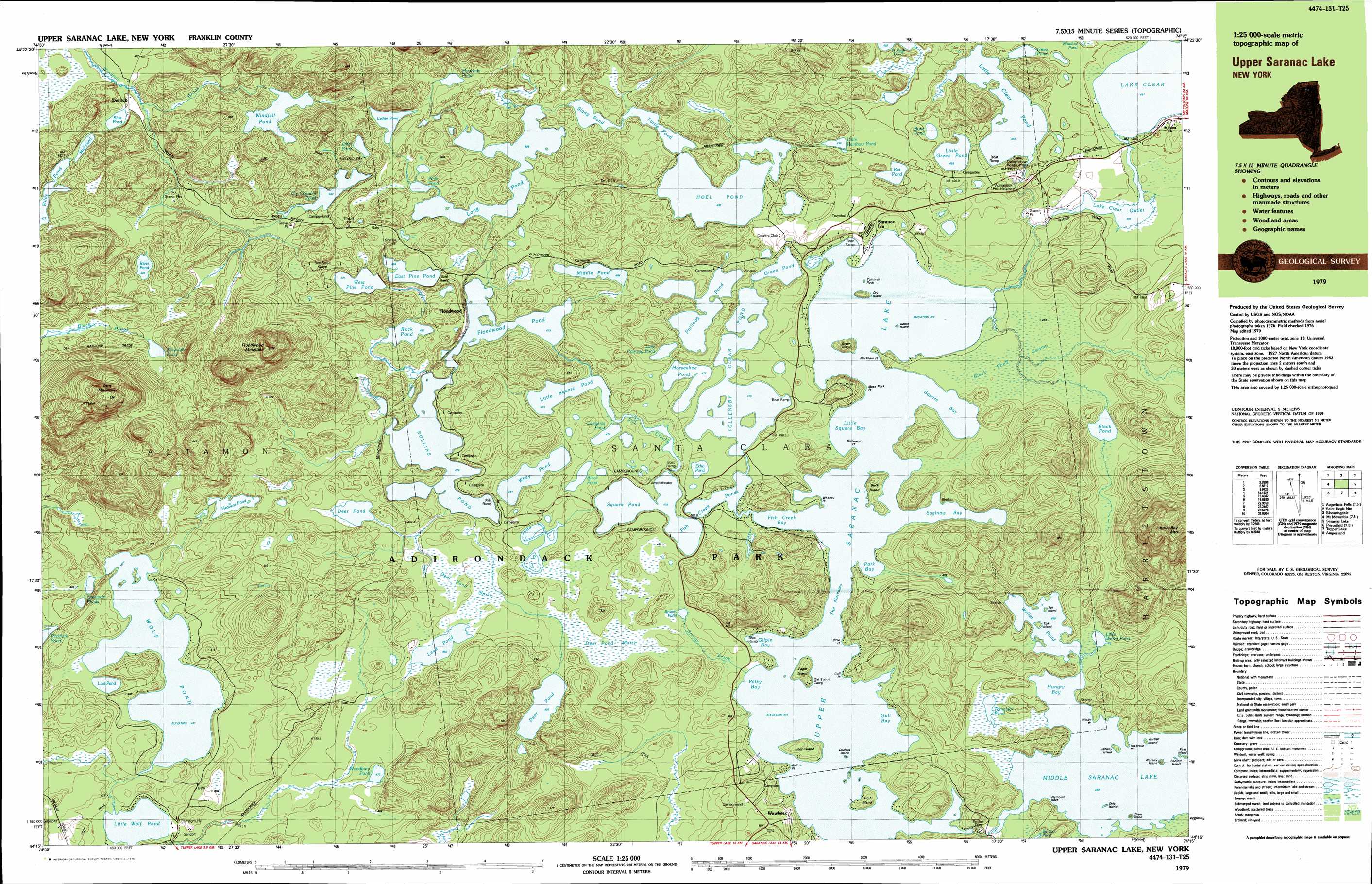
USGS Topo Quad 44074c3 - 1:25,000 scale
| Topo Map Name: | Upper Saranac Lake |
| USGS Topo Quad ID: | 44074c3 |
| Print Size: | ca. 39" wide x 24" high |
| Southeast Coordinates: | 44.25° N latitude / 74.25° W longitude |
| Map Center Coordinates: | 44.3125° N latitude / 74.375° W longitude |
| U.S. State: | NY |
| Filename: | k44074c3.jpg |
| Download Map JPG Image: | Upper Saranac Lake topo map 1:25,000 scale |
| Map Type: | Topographic |
| Topo Series: | 7.5´x15´ |
| Map Scale: | 1:25,000 |
| Source of Map Images: | United States Geological Survey (USGS) |
| Alternate Map Versions: |
Upper Saranac Lake NY 1979, updated 1979 Download PDF Buy paper map Upper Saranac Lake NY 1999, updated 2001 Download PDF Buy paper map |
1:24,000 Topo Quads surrounding Upper Saranac Lake
Lake Ozonia |
Meno |
Meacham Lake |
Debar Mountain |
Loon Lake |
Augerhole Falls |
Saint Regis Mountain |
Bloomingdale |
||
Mount Matumbla |
Upper Saranac Lake |
Mckenzie Mountain |
||
Pierce Field |
Stony Creek Mountain |
Street Mountain |
||
Slim Pond |
Kempshall Mountain |
Mount Adams |
> Back to 44074a1 at 1:100,000 scale
> Back to 44074a1 at 1:250,000 scale
> Back to U.S. Topo Maps home
Upper Saranac Lake topo map: Gazetteer
Upper Saranac Lake: Bays
Fish Creek Bay elevation 479m 1571′Gilpin Bay elevation 479m 1571′
Gull Bay elevation 479m 1571′
Hungry Bay elevation 469m 1538′
Little Square Bay elevation 479m 1571′
Pelky Bay elevation 479m 1571′
Pork Bay elevation 479m 1571′
Saginaw Bay elevation 479m 1571′
Square Bay elevation 479m 1571′
Upper Saranac Lake: Capes
Birch Point elevation 481m 1578′Bull Point elevation 480m 1574′
Butternut Point elevation 481m 1578′
Gull Point elevation 479m 1571′
Markham Point elevation 483m 1584′
Moss Rock Point elevation 479m 1571′
Umbrella Point elevation 470m 1541′
Whitney Point elevation 480m 1574′
Windy Point elevation 470m 1541′
Upper Saranac Lake: Channels
The Narrows elevation 479m 1571′Upper Saranac Lake: Guts
Fish Creek elevation 479m 1571′Upper Saranac Lake: Islands
Bartlett Island elevation 475m 1558′Birch Island elevation 501m 1643′
Buck Island elevation 493m 1617′
Deer Island elevation 493m 1617′
Doctors Island elevation 486m 1594′
Dry Island elevation 495m 1624′
Eagle Island elevation 499m 1637′
First Island elevation 471m 1545′
Goose Island elevation 479m 1571′
Green Island elevation 511m 1676′
Halfway Island elevation 474m 1555′
Norway Island elevation 482m 1581′
Second Island elevation 469m 1538′
Shaw Island elevation 480m 1574′
Ship Island elevation 473m 1551′
Tick Island elevation 477m 1564′
Tot Island elevation 476m 1561′
Upper Saranac Lake: Lakes
Bartlett Pond elevation 471m 1545′Black Pond elevation 488m 1601′
Black Pond elevation 480m 1574′
Blue Pond elevation 477m 1564′
Bone Pond elevation 498m 1633′
Brandy Pond elevation 487m 1597′
Copperas Pond elevation 479m 1571′
Deer Pond elevation 490m 1607′
Deer Pond elevation 491m 1610′
Dry Channel Pond elevation 497m 1630′
East Pine Pond elevation 484m 1587′
Echo Pond elevation 483m 1584′
Fish Creek Ponds elevation 479m 1571′
Floodwood Pond elevation 483m 1584′
Follensby Clear Pond elevation 479m 1571′
Grass Pond elevation 496m 1627′
Green Pond elevation 479m 1571′
Heavens Pond elevation 500m 1640′
Hoel Pond elevation 493m 1617′
Horseshoe Pond elevation 479m 1571′
Lake Clear elevation 491m 1610′
Lead Pond elevation 486m 1594′
Ledge Pond elevation 509m 1669′
Little Clear Pond elevation 487m 1597′
Little Green Pond elevation 488m 1601′
Little Polliwog Pond elevation 479m 1571′
Little Rainbow Pond elevation 493m 1617′
Little Square Pond elevation 479m 1571′
Little Weller Pond elevation 470m 1541′
Little Wolf Pond elevation 478m 1568′
Long Pond elevation 488m 1601′
Lost Pond elevation 481m 1578′
Middle Pond elevation 484m 1587′
Middle Saranac Lake elevation 469m 1538′
Mountain Pond elevation 513m 1683′
Mountain Pond elevation 529m 1735′
Mud Pond elevation 482m 1581′
Otter Pond elevation 519m 1702′
Pink Pond elevation 489m 1604′
Polliwog Pond elevation 479m 1571′
Rat Pond elevation 493m 1617′
River Pond elevation 493m 1617′
Rock Pond elevation 481m 1578′
Rollins Pond elevation 479m 1571′
Slang Pond elevation 493m 1617′
Spectacle Ponds elevation 484m 1587′
Square Pond elevation 479m 1571′
Summit Pond elevation 502m 1646′
Tamarack Pond elevation 467m 1532′
Turtle Pond elevation 493m 1617′
Upper Saranac Lake elevation 479m 1571′
Weller Pond elevation 469m 1538′
West Pine Pond elevation 484m 1587′
Whey Pond elevation 481m 1578′
Willis Pond elevation 477m 1564′
Windfall Pond elevation 502m 1646′
Wolf Pond elevation 481m 1578′
Woodbury Pond elevation 477m 1564′
Upper Saranac Lake: Populated Places
Derrick elevation 476m 1561′Floodwood elevation 480m 1574′
Saranac Inn elevation 488m 1601′
Wawbeek elevation 496m 1627′
Upper Saranac Lake: Streams
Brandy Brook elevation 479m 1571′Lake Clear Outlet elevation 481m 1578′
Upper Saranac Lake: Summits
Boot Bay Mountain elevation 762m 2500′Floodwood Mountain elevation 695m 2280′
Iron Mountain elevation 754m 2473′
Plymouth Rock elevation 471m 1545′
Tommys Rock elevation 479m 1571′
Upper Saranac Lake: Swamps
Black Pond Swamp elevation 481m 1578′Deer Pond Marsh elevation 488m 1601′
Upper Saranac Lake digital topo map on disk
Buy this Upper Saranac Lake topo map showing relief, roads, GPS coordinates and other geographical features, as a high-resolution digital map file on DVD:
New York, Vermont, Connecticut & Western Massachusetts
Buy digital topo maps: New York, Vermont, Connecticut & Western Massachusetts