Bloomingdale Topo Map New York
To zoom in, hover over the map of Bloomingdale
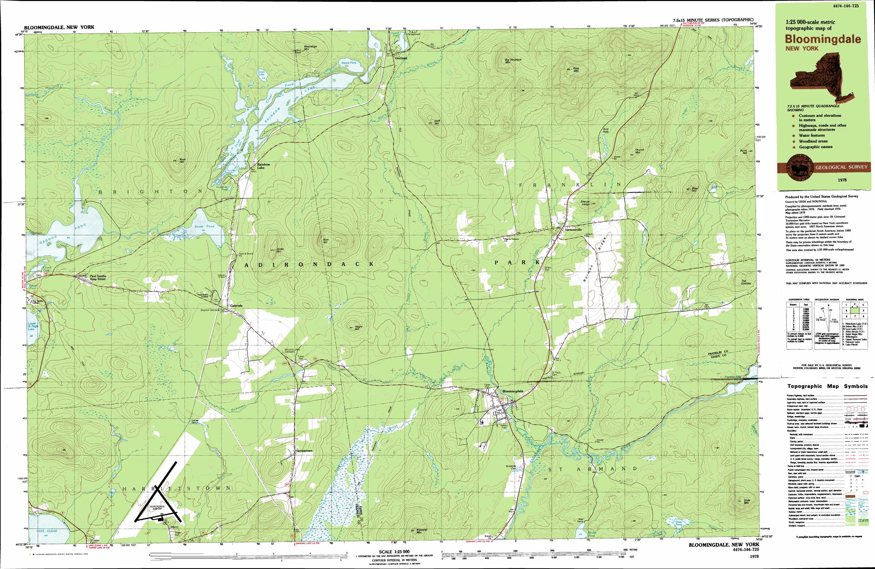
USGS Topo Quad 44074d1 - 1:25,000 scale
| Topo Map Name: | Bloomingdale |
| USGS Topo Quad ID: | 44074d1 |
| Print Size: | ca. 39" wide x 24" high |
| Southeast Coordinates: | 44.375° N latitude / 74° W longitude |
| Map Center Coordinates: | 44.4375° N latitude / 74.125° W longitude |
| U.S. State: | NY |
| Filename: | k44074d1.jpg |
| Download Map JPG Image: | Bloomingdale topo map 1:25,000 scale |
| Map Type: | Topographic |
| Topo Series: | 7.5´x15´ |
| Map Scale: | 1:25,000 |
| Source of Map Images: | United States Geological Survey (USGS) |
| Alternate Map Versions: |
Bloomingdale NY 1978, updated 1978 Download PDF Buy paper map Bloomingdale NY 1999, updated 2001 Download PDF Buy paper map |
1:24,000 Topo Quads surrounding Bloomingdale
Lake Titus |
Owls Head |
Ragged Lake |
Lyon Mountain |
Moffitsville |
Meacham Lake |
Debar Mountain |
Loon Lake |
Alder Brook |
Redford |
Saint Regis Mountain |
Bloomingdale |
Wilmington |
||
Upper Saranac Lake |
Mckenzie Mountain |
Keene |
||
Stony Creek Mountain |
Street Mountain |
Keene Valley |
> Back to 44074a1 at 1:100,000 scale
> Back to 44074a1 at 1:250,000 scale
> Back to U.S. Topo Maps home
Bloomingdale topo map: Gazetteer
Bloomingdale: Airports
Adirondack Regional Airport elevation 500m 1640′Bloomingdale: Benches
Shenes Ledge elevation 596m 1955′Bloomingdale: Lakes
Church Pond elevation 503m 1650′Clear Pond elevation 509m 1669′
Cooler Pond elevation 504m 1653′
Grandmas Pond elevation 507m 1663′
Grass Pond elevation 485m 1591′
Inlet elevation 509m 1669′
Jones Pond elevation 503m 1650′
Loon Lake elevation 513m 1683′
Oregon Pond elevation 518m 1699′
Osgood Pond elevation 503m 1650′
Rainbow Lake elevation 509m 1669′
Square Pond elevation 509m 1669′
The Flow elevation 510m 1673′
Bloomingdale: Populated Places
Bloomingdale elevation 479m 1571′Gabriels elevation 518m 1699′
Harrietstown elevation 565m 1853′
Onchiota elevation 521m 1709′
Paul Smiths Easy Street elevation 509m 1669′
Rainbow Lake elevation 515m 1689′
Vermontville elevation 501m 1643′
Bloomingdale: Ridges
Norman Ridge elevation 550m 1804′Bloomingdale: Streams
Cold Brook elevation 450m 1476′Lyon Brook elevation 475m 1558′
Negro Brook elevation 475m 1558′
Rickerson Brook elevation 475m 1558′
Sumner Brook elevation 450m 1476′
Twobridge Brook elevation 475m 1558′
Bloomingdale: Summits
Big Haystack Mountain elevation 753m 2470′Blue Hill elevation 711m 2332′
Brewster Mountain elevation 666m 2185′
Buck Hill elevation 648m 2125′
Burnt Hill elevation 644m 2112′
Church Mountain elevation 642m 2106′
Jones Hill elevation 671m 2201′
Kate Mountain elevation 863m 2831′
Meenahga Mountain elevation 633m 2076′
Negro Hill elevation 580m 1902′
Pine Hill elevation 618m 2027′
Skiff Mountain elevation 611m 2004′
Slide Mountain elevation 727m 2385′
The Cobbles elevation 624m 2047′
Bloomingdale digital topo map on disk
Buy this Bloomingdale topo map showing relief, roads, GPS coordinates and other geographical features, as a high-resolution digital map file on DVD:
New York, Vermont, Connecticut & Western Massachusetts
Buy digital topo maps: New York, Vermont, Connecticut & Western Massachusetts