Livingston Creek Topo Map Idaho
To zoom in, hover over the map of Livingston Creek
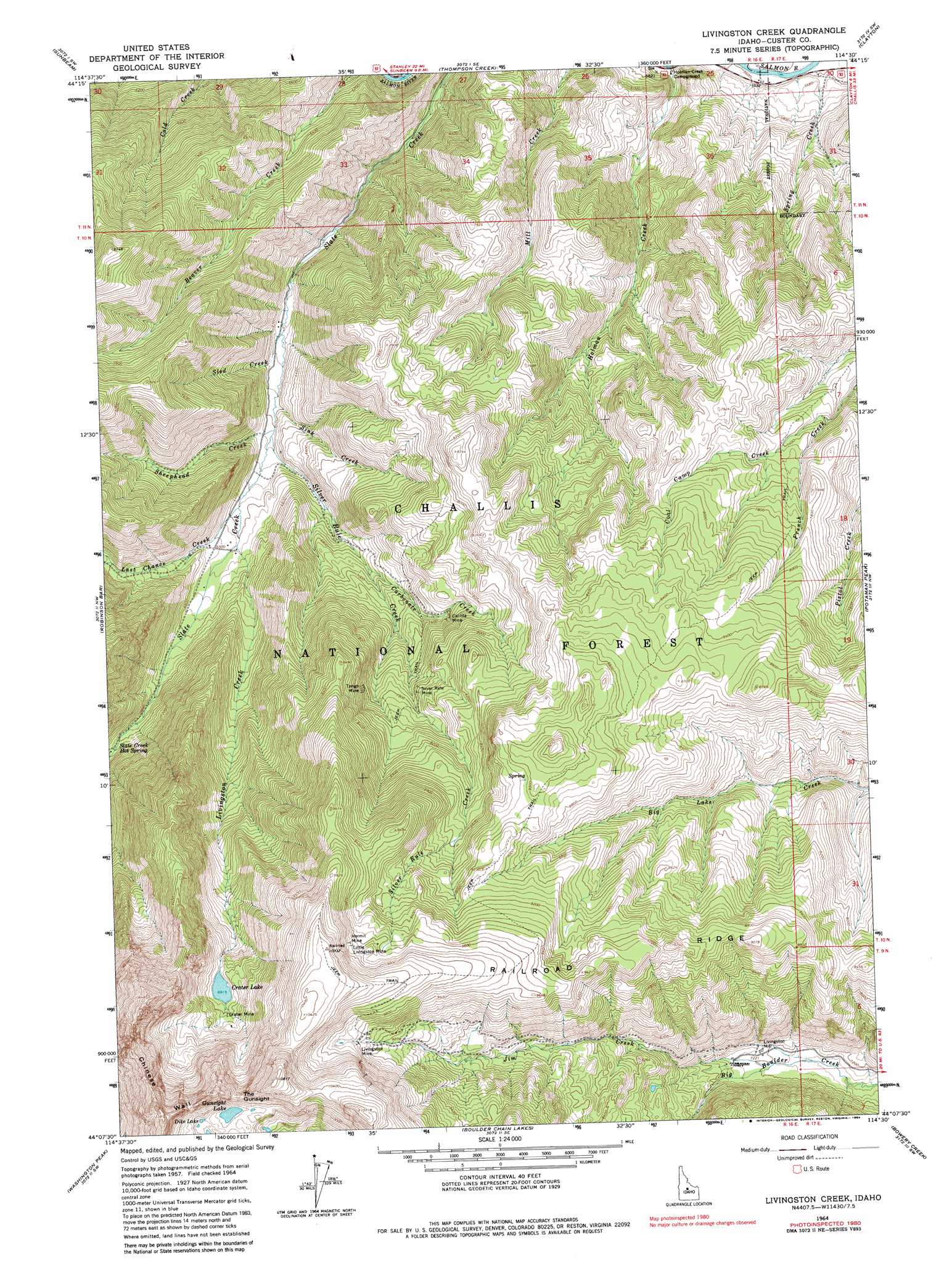
USGS Topo Quad 44114b5 - 1:24,000 scale
| Topo Map Name: | Livingston Creek |
| USGS Topo Quad ID: | 44114b5 |
| Print Size: | ca. 21 1/4" wide x 27" high |
| Southeast Coordinates: | 44.125° N latitude / 114.5° W longitude |
| Map Center Coordinates: | 44.1875° N latitude / 114.5625° W longitude |
| U.S. State: | ID |
| Filename: | o44114b5.jpg |
| Download Map JPG Image: | Livingston Creek topo map 1:24,000 scale |
| Map Type: | Topographic |
| Topo Series: | 7.5´ |
| Map Scale: | 1:24,000 |
| Source of Map Images: | United States Geological Survey (USGS) |
| Alternate Map Versions: |
Livingston Creek ID 1964, updated 1965 Download PDF Buy paper map Livingston Creek ID 1964, updated 1977 Download PDF Buy paper map Livingston Creek ID 1964, updated 1984 Download PDF Buy paper map Livingston Creek ID 1964, updated 1984 Download PDF Buy paper map Livingston Creek ID 2011 Download PDF Buy paper map Livingston Creek ID 2013 Download PDF Buy paper map |
| FStopo: | US Forest Service topo Livingston Creek is available: Download FStopo PDF Download FStopo TIF |
1:24,000 Topo Quads surrounding Livingston Creek
Mount Jordan |
Custer |
Elevenmile Creek |
Bayhorse Lake |
Bayhorse |
East Basin Creek |
Sunbeam |
Thompson Creek |
Clayton |
Bald Mountain |
Casino Lakes |
Robinson Bar |
Livingston Creek |
Potaman Peak |
Ziegler Basin |
Obsidian |
Washington Peak |
Boulder Chain Lakes |
Bowery Creek |
Bowery Peak |
Alturas Lake |
Horton Peak |
Galena Peak |
Ryan Peak |
Meridian Peak |
> Back to 44114a1 at 1:100,000 scale
> Back to 44114a1 at 1:250,000 scale
> Back to U.S. Topo Maps home
Livingston Creek topo map: Gazetteer
Livingston Creek: Cliffs
Chinese Wall elevation 3322m 10898′Livingston Creek: Dams
Hoodoo Mine Number One Dam elevation 2301m 7549′Livingston Creek: Gaps
The Gunsight elevation 3156m 10354′Livingston Creek: Lakes
Crater Lake elevation 2720m 8923′Dike Lake elevation 3092m 10144′
Gunsight Lake elevation 3068m 10065′
Livingston Creek: Mines
Cal-Ida Mine elevation 2245m 7365′Crater Mine elevation 2748m 9015′
Hermit Mine elevation 2980m 9776′
Little Livingston Mine elevation 2975m 9760′
Livingston Mine elevation 2929m 9609′
Silver Rute Mine elevation 2383m 7818′
Tango Mine elevation 2422m 7946′
Livingston Creek: Ridges
Railroad Ridge elevation 2941m 9648′Livingston Creek: Streams
Carbonate Creek elevation 2101m 6893′Coal Camp Fork elevation 2195m 7201′
Holman Creek elevation 1708m 5603′
Jim Creek elevation 2187m 7175′
Last Chance Creek elevation 1941m 6368′
Livingston Creek elevation 1963m 6440′
Sheephead Creek elevation 1896m 6220′
Silver Rule Creek elevation 1898m 6227′
Sink Creek elevation 2052m 6732′
Sled Creek elevation 2074m 6804′
Spring Creek elevation 1720m 5643′
Thompson Creek elevation 1700m 5577′
Livingston Creek digital topo map on disk
Buy this Livingston Creek topo map showing relief, roads, GPS coordinates and other geographical features, as a high-resolution digital map file on DVD: