Carpenter Mountain Topo Map Oregon
To zoom in, hover over the map of Carpenter Mountain
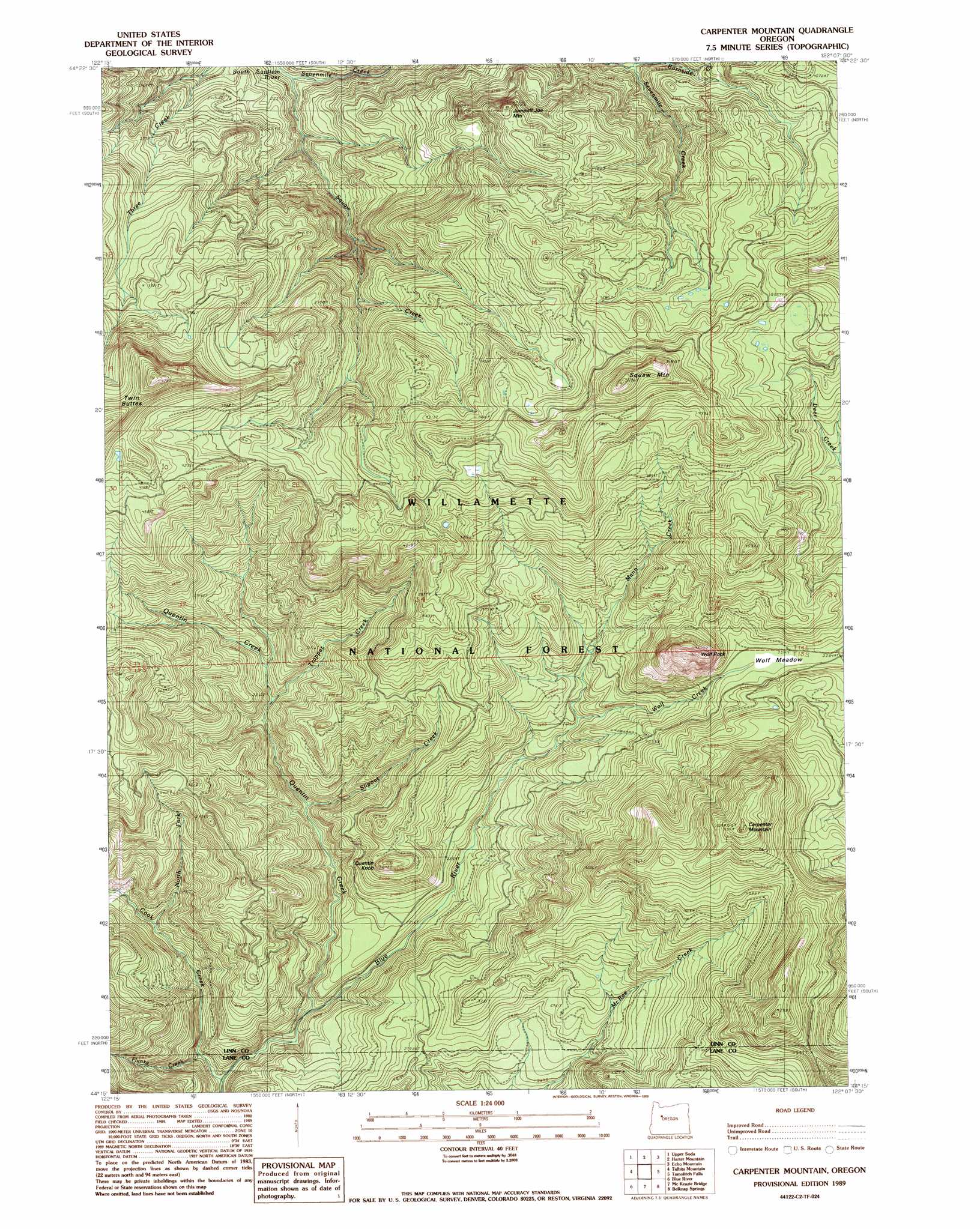
USGS Topo Quad 44122c2 - 1:24,000 scale
| Topo Map Name: | Carpenter Mountain |
| USGS Topo Quad ID: | 44122c2 |
| Print Size: | ca. 21 1/4" wide x 27" high |
| Southeast Coordinates: | 44.25° N latitude / 122.125° W longitude |
| Map Center Coordinates: | 44.3125° N latitude / 122.1875° W longitude |
| U.S. State: | OR |
| Filename: | o44122c2.jpg |
| Download Map JPG Image: | Carpenter Mountain topo map 1:24,000 scale |
| Map Type: | Topographic |
| Topo Series: | 7.5´ |
| Map Scale: | 1:24,000 |
| Source of Map Images: | United States Geological Survey (USGS) |
| Alternate Map Versions: |
Carpenter Mountain OR 1989, updated 1989 Download PDF Buy paper map Carpenter Mountain OR 1997, updated 2001 Download PDF Buy paper map Carpenter Mountain OR 2011 Download PDF Buy paper map Carpenter Mountain OR 2014 Download PDF Buy paper map |
| FStopo: | US Forest Service topo Carpenter Mountain is available: Download FStopo PDF Download FStopo TIF |
1:24,000 Topo Quads surrounding Carpenter Mountain
Yellowstone Mountain |
Quartzville |
Chimney Peak |
Coffin Mountain |
Marion Forks |
Cascadia |
Upper Soda |
Harter Mountain |
Echo Mountain |
Santiam Junction |
Swamp Mountain |
Tidbits Mountain |
Carpenter Mountain |
Tamolitch Falls |
Clear Lake |
Mount Hagan |
Blue River |
Mckenzie Bridge |
Belknap Springs |
Linton Lake |
Nimrod |
Harvey Mountain |
Cougar Reservoir |
French Mountain |
Substitute Point |
> Back to 44122a1 at 1:100,000 scale
> Back to 44122a1 at 1:250,000 scale
> Back to U.S. Topo Maps home
Carpenter Mountain topo map: Gazetteer
Carpenter Mountain: Flats
Wolf Meadow elevation 1011m 3316′Carpenter Mountain: Pillars
Wolf Rock elevation 1334m 4376′Carpenter Mountain: Streams
Burnside Creek elevation 889m 2916′Cadenza Creek elevation 1043m 3421′
Cook Creek elevation 523m 1715′
Flunky Creek elevation 532m 1745′
Latiwi Creek elevation 558m 1830′
Mann Creek elevation 762m 2500′
North Fork Cook Creek elevation 649m 2129′
Quentin Creek elevation 561m 1840′
Sevenmile Creek elevation 561m 1840′
Slipout Creek elevation 654m 2145′
Trapper Creek elevation 719m 2358′
Wolf Creek elevation 762m 2500′
Carpenter Mountain: Summits
Carpenter Mountain elevation 1592m 5223′Jumpoff Joe Mountain elevation 1274m 4179′
Latiwi Mountain elevation 1614m 5295′
Quentin Knob elevation 990m 3248′
Carpenter Mountain: Trails
Three Creek Trail elevation 1119m 3671′Carpenter Mountain digital topo map on disk
Buy this Carpenter Mountain topo map showing relief, roads, GPS coordinates and other geographical features, as a high-resolution digital map file on DVD: