Echo Mountain Topo Map Oregon
To zoom in, hover over the map of Echo Mountain
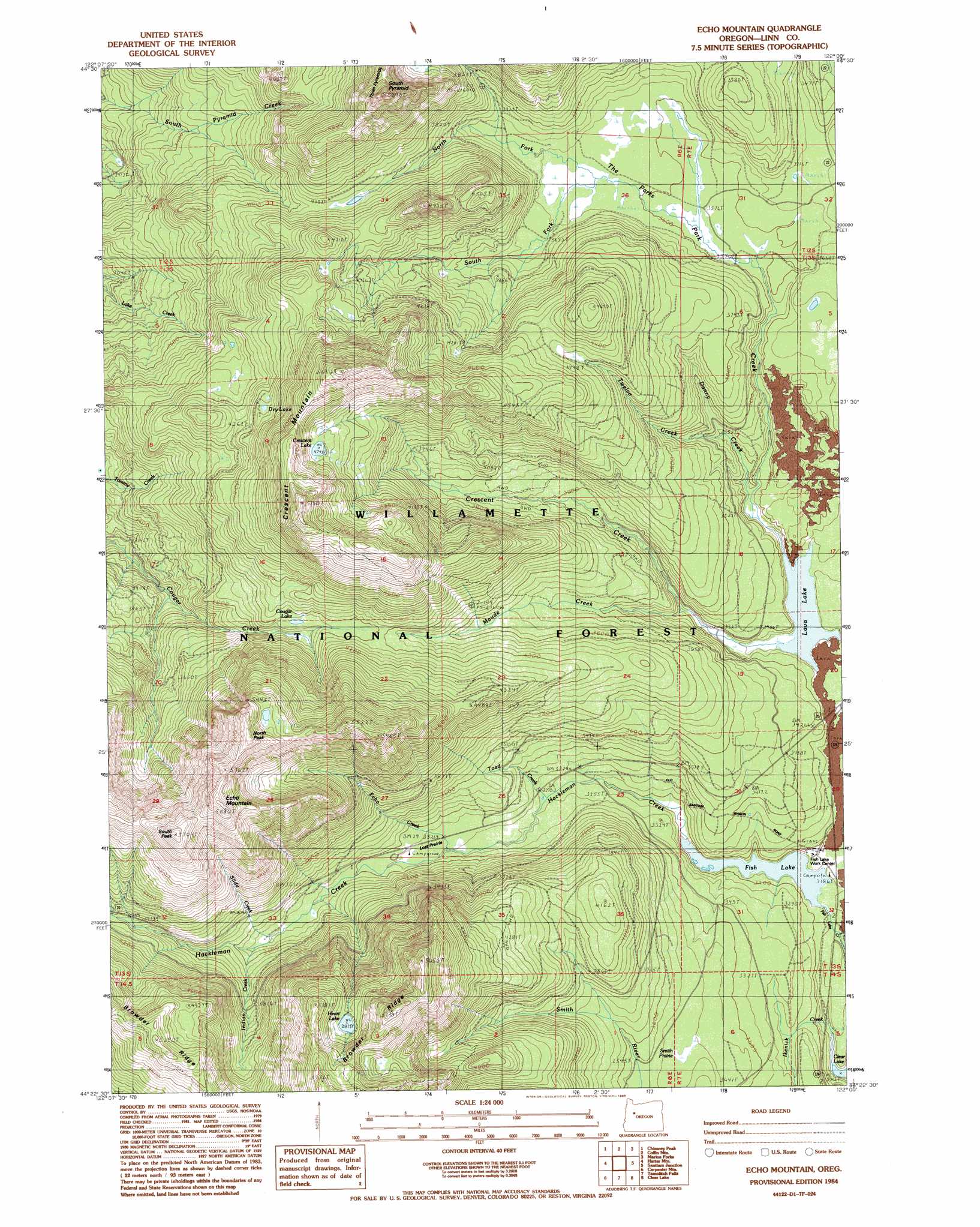
USGS Topo Quad 44122d1 - 1:24,000 scale
| Topo Map Name: | Echo Mountain |
| USGS Topo Quad ID: | 44122d1 |
| Print Size: | ca. 21 1/4" wide x 27" high |
| Southeast Coordinates: | 44.375° N latitude / 122° W longitude |
| Map Center Coordinates: | 44.4375° N latitude / 122.0625° W longitude |
| U.S. State: | OR |
| Filename: | o44122d1.jpg |
| Download Map JPG Image: | Echo Mountain topo map 1:24,000 scale |
| Map Type: | Topographic |
| Topo Series: | 7.5´ |
| Map Scale: | 1:24,000 |
| Source of Map Images: | United States Geological Survey (USGS) |
| Alternate Map Versions: |
Echo Mountain OR 1984, updated 1985 Download PDF Buy paper map Echo Mountain OR 1994, updated 1998 Download PDF Buy paper map Echo Mountain OR 2011 Download PDF Buy paper map Echo Mountain OR 2014 Download PDF Buy paper map |
| FStopo: | US Forest Service topo Echo Mountain is available: Download FStopo PDF Download FStopo TIF |
1:24,000 Topo Quads surrounding Echo Mountain
Lawhead Creek |
Detroit |
Idanha |
Mount Bruno |
Mount Jefferson |
Quartzville |
Chimney Peak |
Coffin Mountain |
Marion Forks |
Marion Lake |
Upper Soda |
Harter Mountain |
Echo Mountain |
Santiam Junction |
Three Fingered Jack |
Tidbits Mountain |
Carpenter Mountain |
Tamolitch Falls |
Clear Lake |
Mount Washington |
Blue River |
Mckenzie Bridge |
Belknap Springs |
Linton Lake |
North Sister |
> Back to 44122a1 at 1:100,000 scale
> Back to 44122a1 at 1:250,000 scale
> Back to U.S. Topo Maps home
Echo Mountain topo map: Gazetteer
Echo Mountain: Flats
Lost Prairie elevation 1018m 3339′Smith Prairie elevation 1055m 3461′
The Parks elevation 1667m 5469′
Echo Mountain: Lakes
Cougar Lake elevation 1205m 3953′Crescent Lake elevation 1449m 4753′
Dry Lake elevation 1322m 4337′
Fish Lake elevation 962m 3156′
Heart Lake elevation 1488m 4881′
Lava Lake elevation 1010m 3313′
Echo Mountain: Streams
Crescent Creek elevation 1010m 3313′Danny Creek elevation 1025m 3362′
Echo Creek elevation 1022m 3353′
Fish Lake Creek elevation 927m 3041′
Hackleman Creek elevation 962m 3156′
Ikenick Creek elevation 930m 3051′
Indian Creek elevation 1082m 3549′
Maude Creek elevation 1024m 3359′
North Fork Park Creek elevation 1104m 3622′
Park Creek elevation 1010m 3313′
Slide Creek elevation 1074m 3523′
South Fork Park Creek elevation 1104m 3622′
Toad Creek elevation 1000m 3280′
Twelve Creek elevation 1046m 3431′
Echo Mountain: Summits
Crescent Mountain elevation 1680m 5511′Echo Mountain elevation 1707m 5600′
North Peak elevation 1690m 5544′
South Peak elevation 1697m 5567′
South Pyramid elevation 1626m 5334′
Echo Mountain: Trails
Crescent Mountain Trail elevation 1391m 4563′Echo Mountain digital topo map on disk
Buy this Echo Mountain topo map showing relief, roads, GPS coordinates and other geographical features, as a high-resolution digital map file on DVD: