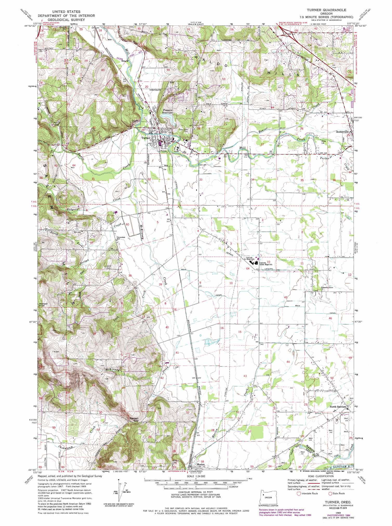
Turner Topo Map Oregon
To zoom in, hover over the map of Turner
USGS Topo Quad 44122g8 - 1:24,000 scale
| Topo Map Name: | Turner |
| USGS Topo Quad ID: | 44122g8 |
| Print Size: | ca. 21 1/4" wide x 27" high |
| Southeast Coordinates: | 44.75° N latitude / 122.875° W longitude |
| Map Center Coordinates: | 44.8125° N latitude / 122.9375° W longitude |
| U.S. State: | OR |
| Filename: | o44122g8.jpg |
| Download Map JPG Image: | Turner topo map 1:24,000 scale |
| Map Type: | Topographic |
| Topo Series: | 7.5´ |
| Map Scale: | 1:24,000 |
| Source of Map Images: | United States Geological Survey (USGS) |
| Alternate Map Versions: |
Turner OR 1969, updated 1971 Download PDF Buy paper map Turner OR 1969, updated 1982 Download PDF Buy paper map Turner OR 1969, updated 1987 Download PDF Buy paper map Turner OR 2011 Download PDF Buy paper map Turner OR 2014 Download PDF Buy paper map |
1:24,000 Topo Quads surrounding Turner
Amity |
Mission Bottom |
Gervais |
Silverton |
Scotts Mills |
Rickreall |
Salem West |
Salem East |
Stayton Ne |
Drake Crossing |
Monmouth |
Sidney |
Turner |
Stayton |
Stout Mountain |
Lewisburg |
Albany |
Crabtree |
Scio |
Jordan |
Riverside |
Tangent |
Lebanon |
Onehorse Slough |
Lacomb |
> Back to 44122e1 at 1:100,000 scale
> Back to 44122a1 at 1:250,000 scale
> Back to U.S. Topo Maps home
Turner topo map: Gazetteer
Turner: Airports
Flying E Airfield elevation 101m 331′Turner: Canals
Main Canal elevation 113m 370′Marion Ditch elevation 106m 347′
Perrin Lateral elevation 100m 328′
Turner: Dams
Franzen Dam elevation 127m 416′Turner: Gaps
Parrish Gap elevation 159m 521′Turner: Lakes
McDonald Pond elevation 89m 291′Turner: Parks
Porter Boone Park elevation 106m 347′Turner: Populated Places
Turner elevation 88m 288′Turner: Post Offices
Turner Post Office elevation 88m 288′Turner: Reservoirs
Franzen Reservoir elevation 127m 416′Seclusia Reservoir elevation 223m 731′
Turner: Streams
Battle Creek elevation 87m 285′Beaver Creek elevation 93m 305′
Cook Creek elevation 94m 308′
McKinney Creek elevation 84m 275′
North Fork Norton Creek elevation 99m 324′
Norton Creek elevation 90m 295′
Porter Creek elevation 102m 334′
Rodgers Creek elevation 89m 291′
Shaw Creek elevation 103m 337′
South Fork Norton Creek elevation 104m 341′
Turner digital topo map on disk
Buy this Turner topo map showing relief, roads, GPS coordinates and other geographical features, as a high-resolution digital map file on DVD: