Bagby Hot Spring Topo Map Oregon
To zoom in, hover over the map of Bagby Hot Spring
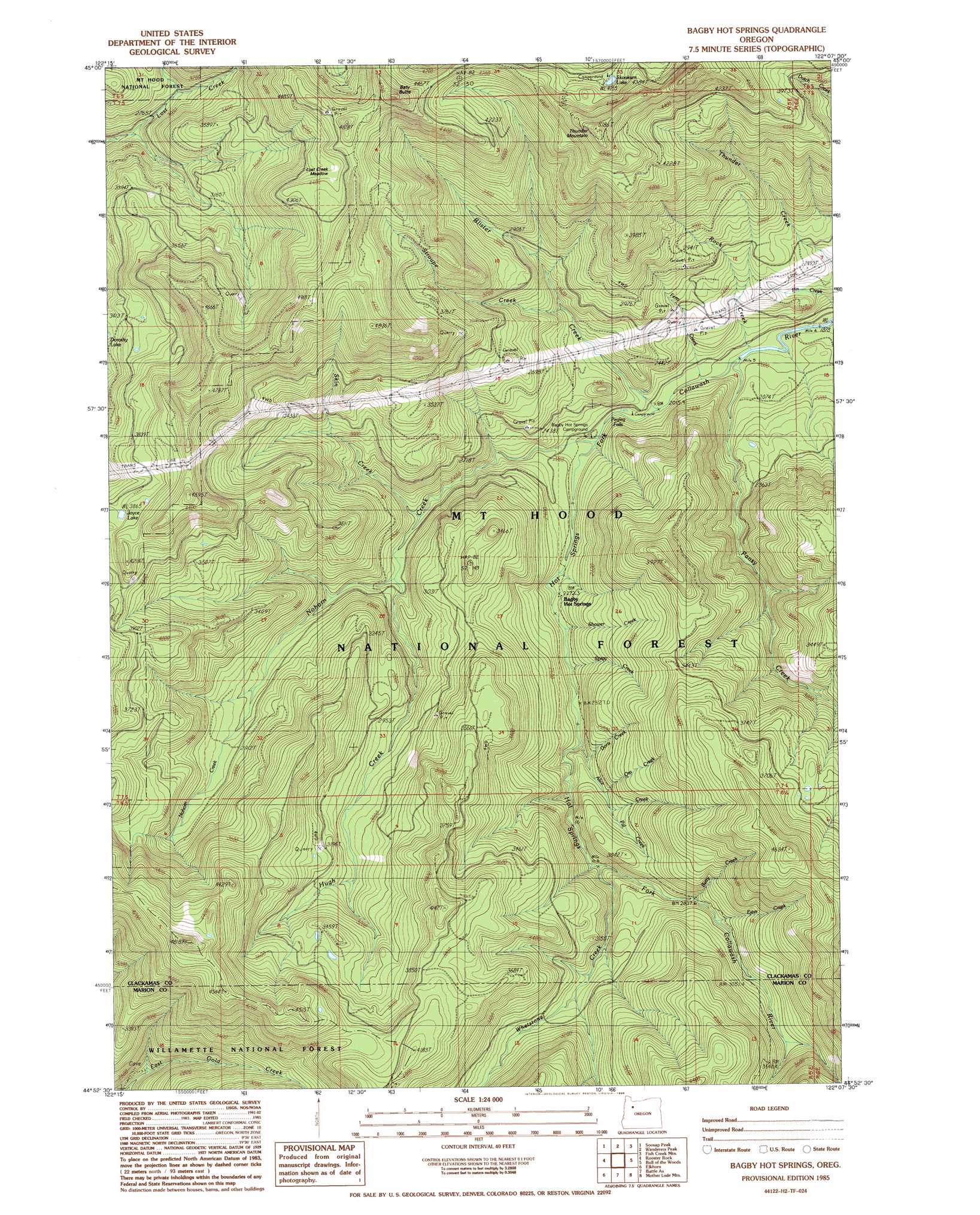
USGS Topo Quad 44122h2 - 1:24,000 scale
| Topo Map Name: | Bagby Hot Spring |
| USGS Topo Quad ID: | 44122h2 |
| Print Size: | ca. 21 1/4" wide x 27" high |
| Southeast Coordinates: | 44.875° N latitude / 122.125° W longitude |
| Map Center Coordinates: | 44.9375° N latitude / 122.1875° W longitude |
| U.S. State: | OR |
| Filename: | o44122h2.jpg |
| Download Map JPG Image: | Bagby Hot Spring topo map 1:24,000 scale |
| Map Type: | Topographic |
| Topo Series: | 7.5´ |
| Map Scale: | 1:24,000 |
| Source of Map Images: | United States Geological Survey (USGS) |
| Alternate Map Versions: |
Bagby Hot Springs OR 1985, updated 1986 Download PDF Buy paper map Bagby Hot Springs OR 1985, updated 1986 Download PDF Buy paper map Bagby Hot Springs OR 1997, updated 1999 Download PDF Buy paper map Bagby Hot Springs OR 2011 Download PDF Buy paper map Bagby Hot Springs OR 2014 Download PDF Buy paper map |
| FStopo: | US Forest Service topo Bagby Hot Springs is available: Download FStopo PDF Download FStopo TIF |
1:24,000 Topo Quads surrounding Bagby Hot Spring
Colton |
Elwood |
Bedford Point |
Three Lynx |
High Rock |
Fernwood |
Soosap Peak |
Wanderers Peak |
Fish Creek Mountain |
Mount Mitchell |
Gawley Creek |
Rooster Rock |
Bagby Hot Spring |
Bull Of The Woods |
Mount Lowe |
Mill City North |
Elkhorn |
Battle Ax |
Mother Lode Mountain |
Breitenbush Hot Spring |
Mill City South |
Lawhead Creek |
Detroit |
Idanha |
Mount Bruno |
> Back to 44122e1 at 1:100,000 scale
> Back to 44122a1 at 1:250,000 scale
> Back to U.S. Topo Maps home
Bagby Hot Spring topo map: Gazetteer
Bagby Hot Spring: Falls
Pegleg Falls elevation 669m 2194′Bagby Hot Spring: Flats
Lost Creek Meadow elevation 1348m 4422′Bagby Hot Spring: Lakes
Joyce Lake elevation 1193m 3914′Skookum Lake elevation 1272m 4173′
Bagby Hot Spring: Springs
Bagby Hot Springs elevation 694m 2276′Bagby Hot Spring: Streams
Alice Creek elevation 710m 2329′Betty Creek elevation 862m 2828′
Blister Creek elevation 622m 2040′
Doris Creek elevation 757m 2483′
Hugh Creek elevation 741m 2431′
Nohorn Creek elevation 651m 2135′
Ora Creek elevation 793m 2601′
Pal Creek elevation 805m 2641′
Pansy Creek elevation 600m 1968′
Peggy Creek elevation 681m 2234′
Perry Creek elevation 605m 1984′
Pin Creek elevation 572m 1876′
Rock Creek elevation 598m 1961′
Shower Creek elevation 694m 2276′
Skin Creek elevation 714m 2342′
Spray Creek elevation 706m 2316′
Stroupe Creek elevation 728m 2388′
Whetstone Creek elevation 780m 2559′
Bagby Hot Spring: Summits
Baty Butte elevation 1538m 5045′Thunder Mountain elevation 1553m 5095′
Bagby Hot Spring: Trails
Baty Silver King Trail elevation 1204m 3950′East Mountain Trail elevation 1392m 4566′
Molalla Trail elevation 930m 3051′
Nohorn Trail elevation 845m 2772′
South Fork Mountain Trail elevation 1149m 3769′
Whetstone Trail elevation 1134m 3720′
Bagby Hot Spring digital topo map on disk
Buy this Bagby Hot Spring topo map showing relief, roads, GPS coordinates and other geographical features, as a high-resolution digital map file on DVD: