Mill City North Topo Map Oregon
To zoom in, hover over the map of Mill City North
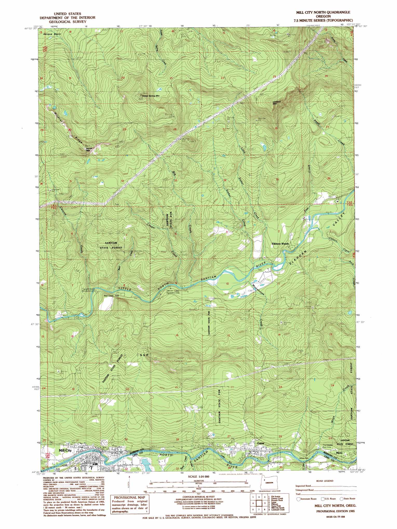
USGS Topo Quad 44122g4 - 1:24,000 scale
| Topo Map Name: | Mill City North |
| USGS Topo Quad ID: | 44122g4 |
| Print Size: | ca. 21 1/4" wide x 27" high |
| Southeast Coordinates: | 44.75° N latitude / 122.375° W longitude |
| Map Center Coordinates: | 44.8125° N latitude / 122.4375° W longitude |
| U.S. State: | OR |
| Filename: | o44122g4.jpg |
| Download Map JPG Image: | Mill City North topo map 1:24,000 scale |
| Map Type: | Topographic |
| Topo Series: | 7.5´ |
| Map Scale: | 1:24,000 |
| Source of Map Images: | United States Geological Survey (USGS) |
| Alternate Map Versions: |
Mill City North OR 1985, updated 1985 Download PDF Buy paper map Mill City North OR 2011 Download PDF Buy paper map Mill City North OR 2014 Download PDF Buy paper map |
1:24,000 Topo Quads surrounding Mill City North
Scotts Mills |
Wilhoit |
Fernwood |
Soosap Peak |
Wanderers Peak |
Drake Crossing |
Elk Prairie |
Gawley Creek |
Rooster Rock |
Bagby Hot Spring |
Stout Mountain |
Lyons |
Mill City North |
Elkhorn |
Battle Ax |
Jordan |
Snow Peak |
Mill City South |
Lawhead Creek |
Detroit |
Lacomb |
Keel Mountain |
Yellowstone Mountain |
Quartzville |
Chimney Peak |
> Back to 44122e1 at 1:100,000 scale
> Back to 44122a1 at 1:250,000 scale
> Back to U.S. Topo Maps home
Mill City North topo map: Gazetteer
Mill City North: Parks
Bear Creek County Park elevation 286m 938′Elkhorn Woods Park elevation 337m 1105′
Kimmel Park elevation 251m 823′
Minto County Park elevation 294m 964′
Mill City North: Populated Places
Elkhorn Woods elevation 334m 1095′Gates elevation 287m 941′
Mill City elevation 246m 807′
Mill City North: Post Offices
Gates Post Office elevation 287m 941′Henness Post Office (historical) elevation 281m 921′
Mill City Post Office elevation 246m 807′
Mill City North: Ridges
Wildcat Ridge elevation 1114m 3654′Mill City North: Streams
Anderson Creek elevation 262m 859′Bear Creek elevation 291m 954′
Big Creek elevation 292m 958′
Buck Creek elevation 371m 1217′
Burbank Creek elevation 293m 961′
Canyon Creek elevation 284m 931′
Chamberlain Creek elevation 304m 997′
Cougar Creek elevation 291m 954′
Doodle Creek elevation 829m 2719′
Elkhorn Creek elevation 327m 1072′
Fish Creek elevation 332m 1089′
Homestead Creek elevation 426m 1397′
Little Sinker Creek elevation 741m 2431′
Mad Creek elevation 279m 915′
Minto Creek elevation 281m 921′
Moorehouse Creek elevation 305m 1000′
Packsaddle Creek elevation 341m 1118′
Pierce Creek elevation 282m 925′
Rock Creek elevation 257m 843′
Sinker Creek elevation 306m 1003′
Turnridge Creek elevation 256m 839′
Wonder Creek elevation 302m 990′
Mill City North: Summits
House Mountain elevation 1200m 3937′Lookout Mountain elevation 1202m 3943′
Sweet Spring Mountain elevation 1238m 4061′
Mill City North: Valleys
Elkhorn Valley elevation 281m 921′Mill City North digital topo map on disk
Buy this Mill City North topo map showing relief, roads, GPS coordinates and other geographical features, as a high-resolution digital map file on DVD: