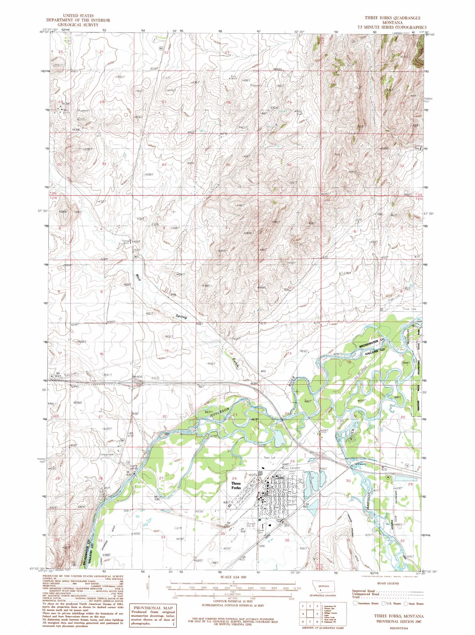
Three Forks Topo Map Montana
To zoom in, hover over the map of Three Forks
USGS Topo Quad 45111h5 - 1:24,000 scale
| Topo Map Name: | Three Forks |
| USGS Topo Quad ID: | 45111h5 |
| Print Size: | ca. 21 1/4" wide x 27" high |
| Southeast Coordinates: | 45.875° N latitude / 111.5° W longitude |
| Map Center Coordinates: | 45.9375° N latitude / 111.5625° W longitude |
| U.S. State: | MT |
| Filename: | o45111h5.jpg |
| Download Map JPG Image: | Three Forks topo map 1:24,000 scale |
| Map Type: | Topographic |
| Topo Series: | 7.5´ |
| Map Scale: | 1:24,000 |
| Source of Map Images: | United States Geological Survey (USGS) |
| Alternate Map Versions: |
Three Forks MT 1987, updated 1987 Download PDF Buy paper map Three Forks MT 2011 Download PDF Buy paper map Three Forks MT 2014 Download PDF Buy paper map |
1:24,000 Topo Quads surrounding Three Forks
Devils Fence |
Radersburg |
Parker |
Toston |
Deer Park |
Willow Springs |
Radersburg Sw |
Plunket Lake |
Lombard |
Roy Gulch |
Negro Hollow |
Milligan Canyon |
Three Forks |
Logan |
Nixon Gulch |
Sappington |
Willow Creek |
Three Forks Se |
Manhattan Sw |
Manhattan |
Harrison |
Willow Creek Reservoir |
Norris Ne |
Madison Plateau |
Anceney |
> Back to 45111e1 at 1:100,000 scale
> Back to 45110a1 at 1:250,000 scale
> Back to U.S. Topo Maps home
Three Forks topo map: Gazetteer
Three Forks: Airports
Hasskamp Airport elevation 1235m 4051′Three Forks Airport elevation 1244m 4081′
Three Forks: Bridges
Haskin Bridge (historical) elevation 1245m 4084′Jefferson River Bridge elevation 1238m 4061′
Pyfer Bridge (historical) elevation 1232m 4041′
Three Forks: Crossings
Interchange 274 elevation 1286m 4219′Interchange 278 elevation 1239m 4064′
Three Forks: Dams
Pacabo Dam elevation 1242m 4074′Three Forks: Parks
Memorial Park elevation 1241m 4071′Milwaukee Park elevation 1244m 4081′
Peterson Park elevation 1242m 4074′
Sacajawea Park elevation 1242m 4074′
Stevenson Park elevation 1241m 4071′
Three Forks of the Missouri Historical Marker elevation 1239m 4064′
Three Forks Pond elevation 1238m 4061′
Tom Bertagnolli Park elevation 1240m 4068′
Three Forks: Populated Places
Copper City elevation 1415m 4642′Jefferson (historical) elevation 1243m 4078′
Murphys Trailer Court elevation 1241m 4071′
Three Forks elevation 1242m 4074′
Three Forks Junction elevation 1257m 4124′
Three Forks: Post Offices
Madison Post Office (historical) elevation 1237m 4058′Three Forks Post Office elevation 1242m 4074′
Three Forks: Streams
Jefferson River elevation 1232m 4041′Madison River elevation 1232m 4041′
Three Forks: Valleys
Mud Spring Gulch elevation 1243m 4078′Three Forks: Wells
02N01E04BCAA01 Well elevation 1292m 4238′02N01E04BDCC01 Well elevation 1288m 4225′
02N01E04DBDC01 Well elevation 1283m 4209′
02N01E04DBDD01 Well elevation 1282m 4206′
02N01E08DDCA01 Well elevation 1306m 4284′
02N01E17ADBC01 Well elevation 1301m 4268′
02N01E17DAAD01 Well elevation 1300m 4265′
02N01E24BADA01 Well elevation 1245m 4084′
02N01E24DDA_01 Well elevation 1238m 4061′
02N01E24DDAA01 Well elevation 1238m 4061′
02N01E25AACC01 Well elevation 1241m 4071′
02N01E25AB__01 Well elevation 1244m 4081′
02N01E25BDBB01 Well elevation 1241m 4071′
02N01E25CBBD01 Well elevation 1242m 4074′
02N01E26AA__01 Well elevation 1240m 4068′
02N01E26DCDC01 Well elevation 1244m 4081′
02N01E26DDDA01 Well elevation 1242m 4074′
02N01E27BCCB01 Well elevation 1251m 4104′
02N01E27CBD_01 Well elevation 1245m 4084′
02N01E28DBDC01 Well elevation 1268m 4160′
02N01E28DCAB01 Well elevation 1270m 4166′
02N01E28DCBC01 Well elevation 1255m 4117′
02N01E34AAAD01 Well elevation 1244m 4081′
02N01E34AABA01 Well elevation 1244m 4081′
02N01E35BABA01 Well elevation 1245m 4084′
02N01E35BABA02 Well elevation 1245m 4084′
02N01E35DDDA01 Well elevation 1245m 4084′
02N01E36BAAC01 Well elevation 1241m 4071′
02N01E36BCBD01 Well elevation 1243m 4078′
02N01E36BCDD01 Well elevation 1244m 4081′
02N01E36CBA_01 Well elevation 1243m 4078′
02N02E19CBCC01 Well elevation 1237m 4058′
02N02E19CCAB01 Well elevation 1237m 4058′
02N02E19CCB_01 Well elevation 1237m 4058′
02N02E19CCCB01 Well elevation 1239m 4064′
02N02E19CCCB02 Well elevation 1239m 4064′
02N02E20CABC01 Well elevation 1236m 4055′
02N02E20CBDC01 Well elevation 1236m 4055′
02N02E20CCAA01 Well elevation 1236m 4055′
02N02E20CDAC01 Well elevation 1236m 4055′
02N02E29BABD01 Well elevation 1240m 4068′
02N02E29BABD02 Well elevation 1240m 4068′
02N02E30CDAA01 Well elevation 1242m 4074′
02N02E30DCBC01 Well elevation 1242m 4074′
Three Forks digital topo map on disk
Buy this Three Forks topo map showing relief, roads, GPS coordinates and other geographical features, as a high-resolution digital map file on DVD: