Green Mountain Topo Map Idaho
To zoom in, hover over the map of Green Mountain
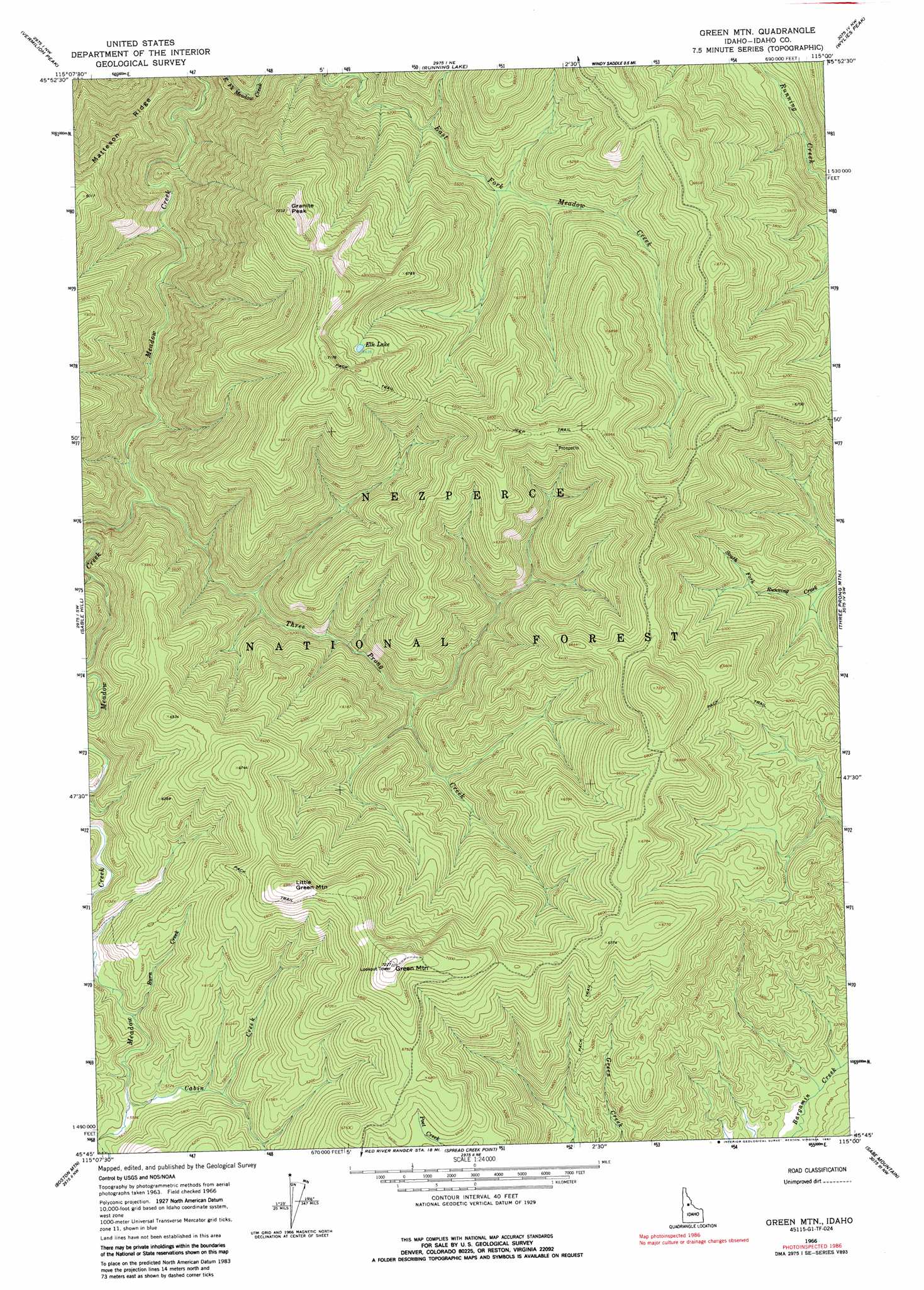
USGS Topo Quad 45115g1 - 1:24,000 scale
| Topo Map Name: | Green Mountain |
| USGS Topo Quad ID: | 45115g1 |
| Print Size: | ca. 21 1/4" wide x 27" high |
| Southeast Coordinates: | 45.75° N latitude / 115° W longitude |
| Map Center Coordinates: | 45.8125° N latitude / 115.0625° W longitude |
| U.S. State: | ID |
| Filename: | o45115g1.jpg |
| Download Map JPG Image: | Green Mountain topo map 1:24,000 scale |
| Map Type: | Topographic |
| Topo Series: | 7.5´ |
| Map Scale: | 1:24,000 |
| Source of Map Images: | United States Geological Survey (USGS) |
| Alternate Map Versions: |
Green Mtn. ID 1966, updated 1968 Download PDF Buy paper map Green Mountain ID 1966, updated 1987 Download PDF Buy paper map Green Mountain ID 1995, updated 1999 Download PDF Buy paper map Green Mountain ID 2011 Download PDF Buy paper map Green Mountain ID 2013 Download PDF Buy paper map |
| FStopo: | US Forest Service topo Green Mountain is available: Download FStopo PDF Download FStopo TIF |
1:24,000 Topo Quads surrounding Green Mountain
Selway Falls |
Fog Mountain |
Mink Peak |
Moose Ridge |
Dog Creek |
Anderson Butte |
Vermilion Peak |
Running Lake |
Wylies Peak |
Gardiner Peak |
Black Hawk Mountain |
Sable Hill |
Green Mountain |
Three Prong Mountain |
Spot Mountain |
Trapper Creek |
Boston Mountain |
Spread Creek Point |
Sabe Mountain |
Magruder Mountain |
Whitewater Ranch |
Hida Point |
Sheep Hill |
Dennis Mountain |
Stripe Mountain |
> Back to 45115e1 at 1:100,000 scale
> Back to 45114a1 at 1:250,000 scale
> Back to U.S. Topo Maps home
Green Mountain topo map: Gazetteer
Green Mountain: Lakes
Elk Lake elevation 2029m 6656′Green Mountain: Parks
Middle Fork Salmon Wild and Scenic River elevation 2075m 6807′Green Mountain: Streams
Burn Creek elevation 1680m 5511′Cabin Creek elevation 1695m 5561′
Meadow Creek elevation 1301m 4268′
Three Prong Creek elevation 1486m 4875′
Green Mountain: Summits
Granite Peak elevation 2164m 7099′Green Mountain elevation 2198m 7211′
Little Green Mountain elevation 2127m 6978′
Green Mountain digital topo map on disk
Buy this Green Mountain topo map showing relief, roads, GPS coordinates and other geographical features, as a high-resolution digital map file on DVD: