Wapshilla Creek Topo Map Idaho
To zoom in, hover over the map of Wapshilla Creek
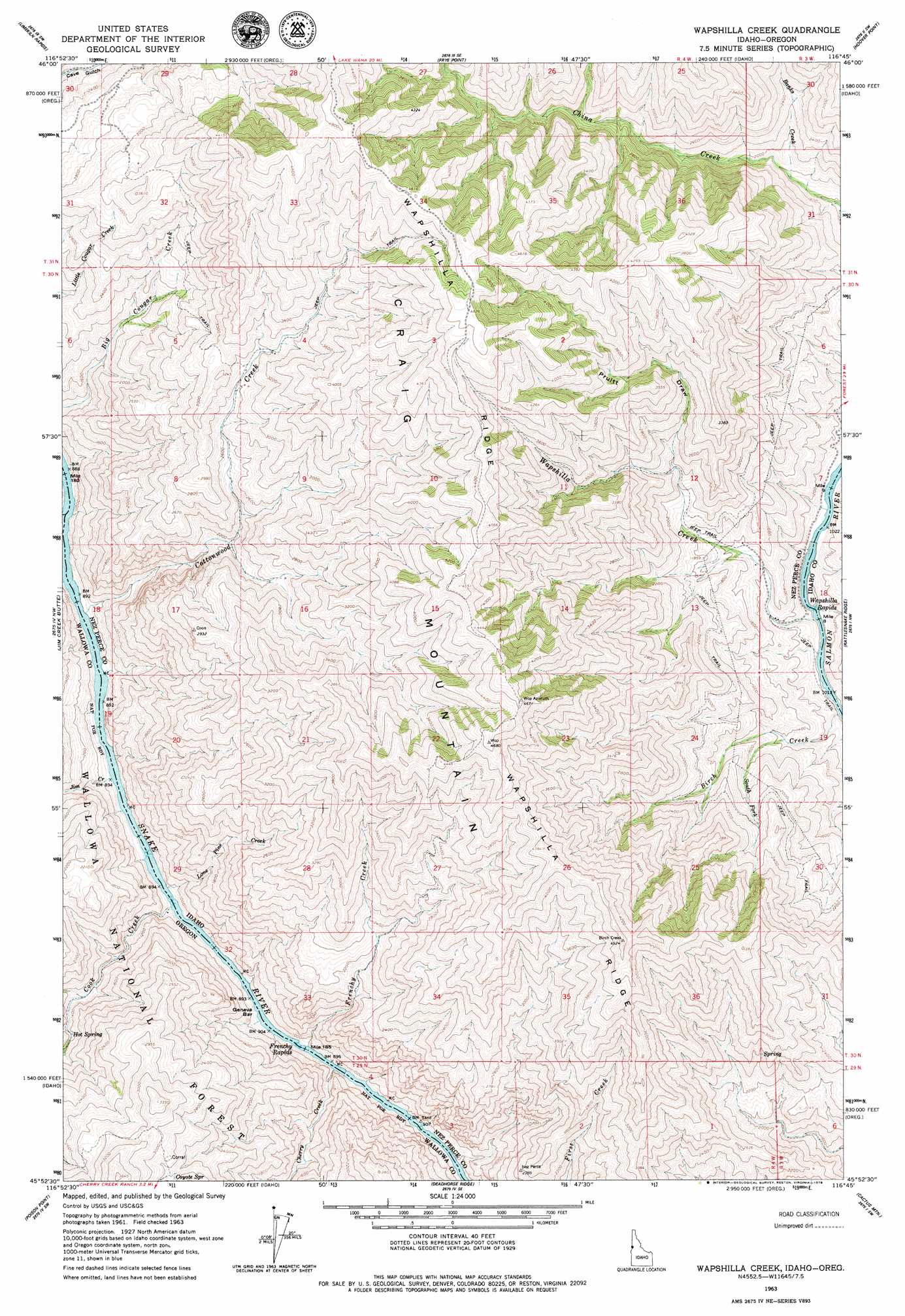
USGS Topo Quad 45116h7 - 1:24,000 scale
| Topo Map Name: | Wapshilla Creek |
| USGS Topo Quad ID: | 45116h7 |
| Print Size: | ca. 21 1/4" wide x 27" high |
| Southeast Coordinates: | 45.875° N latitude / 116.75° W longitude |
| Map Center Coordinates: | 45.9375° N latitude / 116.8125° W longitude |
| U.S. States: | ID, OR |
| Filename: | o45116h7.jpg |
| Download Map JPG Image: | Wapshilla Creek topo map 1:24,000 scale |
| Map Type: | Topographic |
| Topo Series: | 7.5´ |
| Map Scale: | 1:24,000 |
| Source of Map Images: | United States Geological Survey (USGS) |
| Alternate Map Versions: |
Wapshilla Creek ID 1963, updated 1965 Download PDF Buy paper map Wapshilla Creek ID 1963, updated 1979 Download PDF Buy paper map Wapshilla Creek ID 2011 Download PDF Buy paper map Wapshilla Creek ID 2013 Download PDF Buy paper map |
| FStopo: | US Forest Service topo Wapshilla Creek is available: Download FStopo PDF Download FStopo TIF |
1:24,000 Topo Quads surrounding Wapshilla Creek
Weissenfels Ridge |
Captain John Rapids |
Waha |
Winchester West |
Winchester East |
Black Butte |
Limekiln Rapids |
Frye Point |
Hoover Point |
Westlake |
Teepee Butte |
Jim Creek Butte |
Wapshilla Creek |
Rattlesnake Ridge |
Boles |
Billy Meadows |
Poison Point |
Deadhorse Ridge |
Cactus Mountain |
Wolf Creek |
Greenwood Butte |
Zumwalt |
Haas Hollow |
Fingerboard Saddle |
Lord Flat |
> Back to 45116e1 at 1:100,000 scale
> Back to 45116a1 at 1:250,000 scale
> Back to U.S. Topo Maps home
Wapshilla Creek topo map: Gazetteer
Wapshilla Creek: Bars
Geneva Bar elevation 269m 882′Wapshilla Creek: Rapids
Frenchy Rapids elevation 269m 882′Frenchy Rapids elevation 269m 882′
Wapshilla Rapids elevation 305m 1000′
Wapshilla Creek: Ridges
Wapshilla Ridge elevation 1391m 4563′Wapshilla Creek: Springs
Coyote Spring elevation 844m 2769′Hot Spring elevation 425m 1394′
Wapshilla Creek: Streams
Banks Creek elevation 538m 1765′Birch Creek elevation 307m 1007′
Cherry Creek elevation 297m 974′
Cook Creek elevation 268m 879′
Cottonwood Creek elevation 277m 908′
Frenchy Creek elevation 273m 895′
Jim Creek elevation 270m 885′
Lone Pine Creek elevation 294m 964′
South Fork Birch Creek elevation 413m 1354′
Wapshilla Creek elevation 306m 1003′
Wapshilla Creek: Valleys
Pruitt Draw elevation 670m 2198′Wapshilla Creek digital topo map on disk
Buy this Wapshilla Creek topo map showing relief, roads, GPS coordinates and other geographical features, as a high-resolution digital map file on DVD: