Gwinn Topo Map Michigan
To zoom in, hover over the map of Gwinn
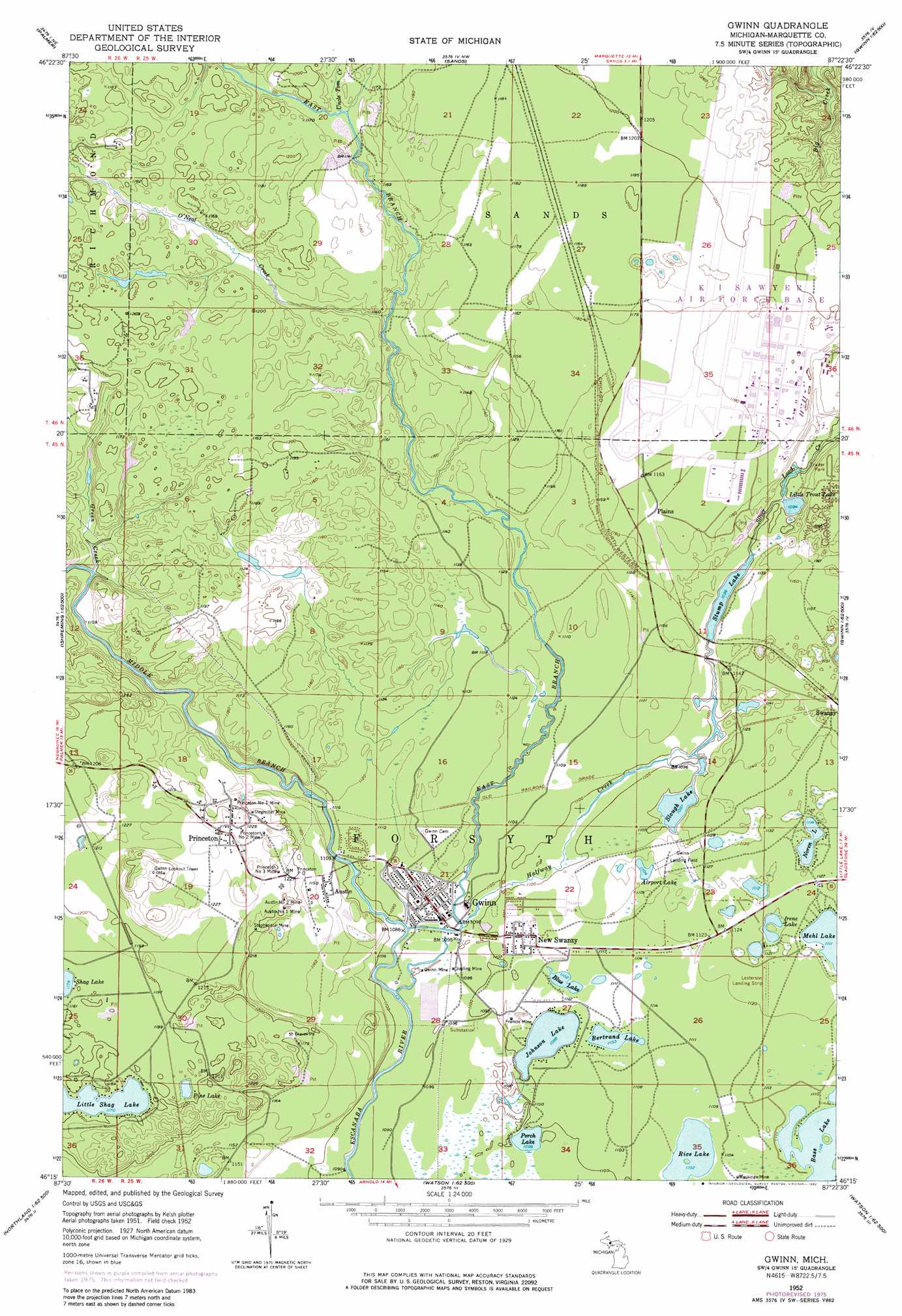
USGS Topo Quad 46087c4 - 1:24,000 scale
| Topo Map Name: | Gwinn |
| USGS Topo Quad ID: | 46087c4 |
| Print Size: | ca. 21 1/4" wide x 27" high |
| Southeast Coordinates: | 46.25° N latitude / 87.375° W longitude |
| Map Center Coordinates: | 46.3125° N latitude / 87.4375° W longitude |
| U.S. State: | MI |
| Filename: | o46087c4.jpg |
| Download Map JPG Image: | Gwinn topo map 1:24,000 scale |
| Map Type: | Topographic |
| Topo Series: | 7.5´ |
| Map Scale: | 1:24,000 |
| Source of Map Images: | United States Geological Survey (USGS) |
| Alternate Map Versions: |
Gwinn MI 1952, updated 1954 Download PDF Buy paper map Gwinn MI 1952, updated 1970 Download PDF Buy paper map Gwinn MI 1952, updated 1977 Download PDF Buy paper map Gwinn MI 1952, updated 1982 Download PDF Buy paper map Gwinn MI 2011 Download PDF Buy paper map Gwinn MI 2014 Download PDF Buy paper map Gwinn MI 2017 Download PDF Buy paper map |
1:24,000 Topo Quads surrounding Gwinn
Negaunee Sw |
Negaunee |
Marquette |
||
Ishpeming |
Palmer |
Sands |
Harvey |
Skandia |
Green Hills |
Cataract Basin |
Gwinn |
Little Lake |
Carlshend |
Northland Nw |
Northland Ne |
Anderson Lake |
Helena |
Mcfarland |
Alfred |
Northland |
Arnold |
Swimming Hole Creek |
Rock |
> Back to 46087a1 at 1:100,000 scale
> Back to 46086a1 at 1:250,000 scale
> Back to U.S. Topo Maps home
Gwinn topo map: Gazetteer
Gwinn: Airports
Lesterson Field elevation 341m 1118′Sawyer International Airport elevation 360m 1181′
Gwinn: Lakes
Bertraud Lake elevation 336m 1102′Blue Lake elevation 336m 1102′
Irene Lake elevation 341m 1118′
Johnson Lake elevation 335m 1099′
Little Shag Lake elevation 357m 1171′
Little Trout Lake elevation 334m 1095′
Noren Lake elevation 340m 1115′
Perch Lake elevation 334m 1095′
Pine Lake elevation 359m 1177′
Rice Lake elevation 336m 1102′
Slough Lake elevation 334m 1095′
Stump Lake elevation 334m 1095′
Gwinn: Mines
Austin Number One Mine elevation 365m 1197′Austin Number Two Mine elevation 370m 1213′
Francis Mine elevation 340m 1115′
Gwinn Mine elevation 334m 1095′
Jopling Mine elevation 333m 1092′
Mackinaw Mine elevation 341m 1118′
Princeton Number One Mine elevation 358m 1174′
Princeton Number Three Mine elevation 376m 1233′
Princeton Number Two Mine elevation 377m 1236′
Stegmiller Mine elevation 372m 1220′
Stephenson Mine elevation 368m 1207′
Gwinn: Parks
Farquar-Metsa Tourist Park elevation 343m 1125′Forsyth Township Ball Park elevation 335m 1099′
Little Trout Lake Park elevation 335m 1099′
Peter Nordeen Park elevation 333m 1092′
Gwinn: Populated Places
Austin elevation 349m 1145′Gwinn elevation 335m 1099′
K I Sawyer elevation 341m 1118′
New Swanzy elevation 338m 1108′
Northernair Mobile Estates elevation 338m 1108′
Plains elevation 354m 1161′
Princeton elevation 377m 1236′
Gwinn: Post Offices
Gwinn Post Office elevation 333m 1092′Princeton Post Office elevation 373m 1223′
Princeton Post Office (historical) elevation 376m 1233′
Swanzy Post Office (historical) elevation 347m 1138′
Gwinn: Streams
East Branch Escanaba River elevation 328m 1076′Green Creek elevation 333m 1092′
Halfway Creek elevation 334m 1095′
Middle Branch Escanaba River elevation 328m 1076′
O'Neal Creek elevation 340m 1115′
Uncle Tom Creek elevation 348m 1141′
Gwinn digital topo map on disk
Buy this Gwinn topo map showing relief, roads, GPS coordinates and other geographical features, as a high-resolution digital map file on DVD: