Lignite Creek Topo Map Montana
To zoom in, hover over the map of Lignite Creek
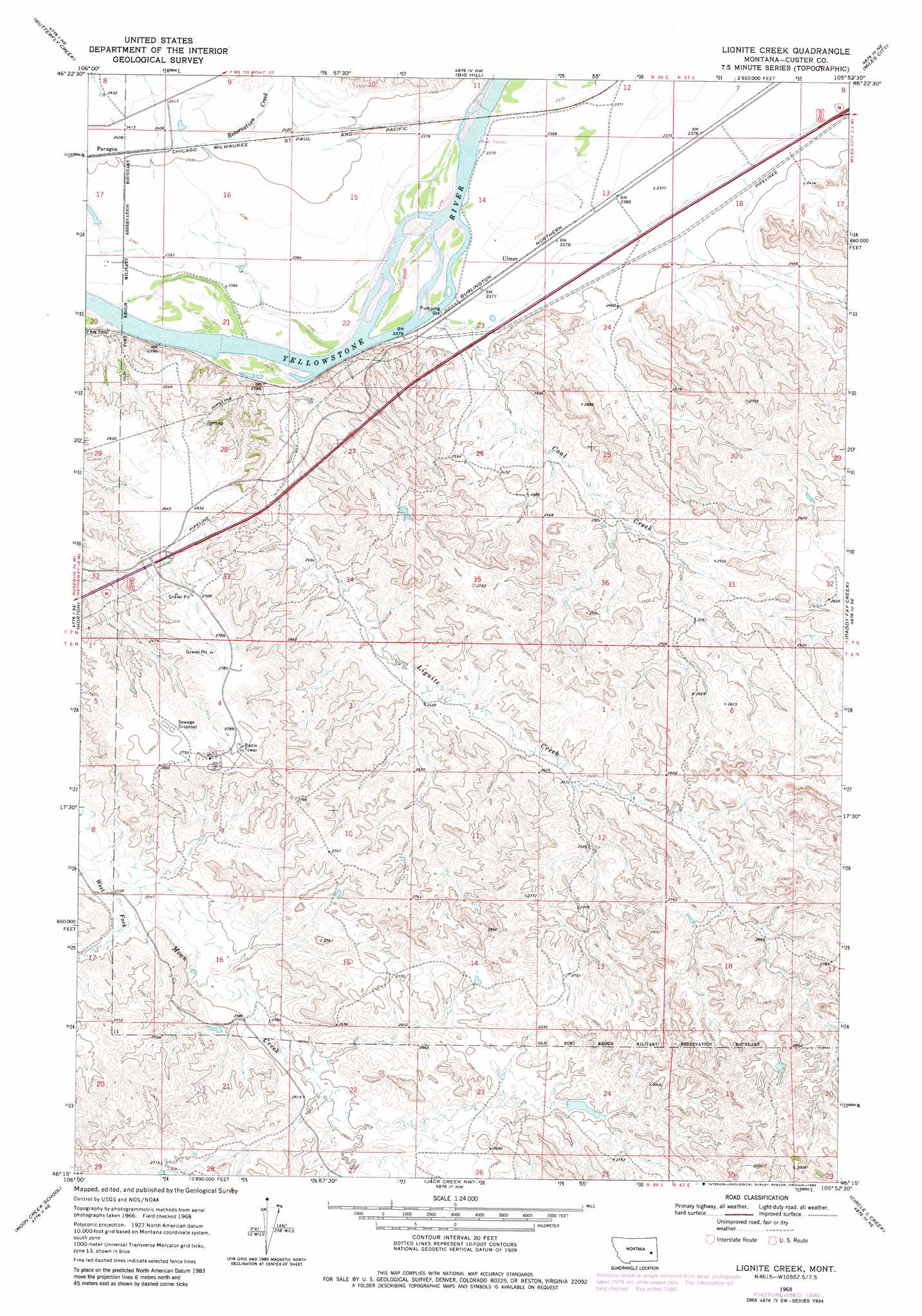
USGS Topo Quad 46105c8 - 1:24,000 scale
| Topo Map Name: | Lignite Creek |
| USGS Topo Quad ID: | 46105c8 |
| Print Size: | ca. 21 1/4" wide x 27" high |
| Southeast Coordinates: | 46.25° N latitude / 105.875° W longitude |
| Map Center Coordinates: | 46.3125° N latitude / 105.9375° W longitude |
| U.S. State: | MT |
| Filename: | o46105c8.jpg |
| Download Map JPG Image: | Lignite Creek topo map 1:24,000 scale |
| Map Type: | Topographic |
| Topo Series: | 7.5´ |
| Map Scale: | 1:24,000 |
| Source of Map Images: | United States Geological Survey (USGS) |
| Alternate Map Versions: |
Lignite Creek MT 1968, updated 1972 Download PDF Buy paper map Lignite Creek MT 1968, updated 1980 Download PDF Buy paper map Lignite Creek MT 2011 Download PDF Buy paper map Lignite Creek MT 2014 Download PDF Buy paper map |
1:24,000 Topo Quads surrounding Lignite Creek
Hobo Coulee |
N Bar Coulee |
Deadman Creek |
Noble Reservoir |
Kinsey |
Hathaway Nw |
Butterfly Creek |
Big Hill |
Miles City |
Government Hill |
Hathaway |
Horton |
Lignite Creek |
Paddy Fay Creek |
Whitney Creek |
Miller Creek Nw |
Moon Creek School |
Jack Creek Nw |
Circle L Creek |
Horse Creek |
Miller Creek Sw |
Miller Creek |
Garland School |
Jack Creek |
Beebe Sw |
> Back to 46105a1 at 1:100,000 scale
> Back to 46104a1 at 1:250,000 scale
> Back to U.S. Topo Maps home
Lignite Creek topo map: Gazetteer
Lignite Creek: Bridges
Paragon Bridge elevation 719m 2358′Lignite Creek: Crossings
Interchange 128 elevation 803m 2634′Lignite Creek: Populated Places
Ulmer elevation 723m 2372′Lignite Creek: Streams
Coal Creek elevation 720m 2362′Lignite Creek elevation 719m 2358′
Reservation Creek elevation 734m 2408′
West Fork Moon Creek elevation 772m 2532′
Lignite Creek: Wells
06N46E04CDB_01 Well elevation 859m 2818′06N46E04DCA_01 Well elevation 861m 2824′
06N46E12ABDA01 Well elevation 795m 2608′
06N46E22CDBA01 Well elevation 789m 2588′
07N46E12DBC_01 Well elevation 723m 2372′
07N46E24ACBD01 Well elevation 730m 2395′
07N47E31CCAA01 Well elevation 774m 2539′
Lignite Creek digital topo map on disk
Buy this Lignite Creek topo map showing relief, roads, GPS coordinates and other geographical features, as a high-resolution digital map file on DVD:
Eastern Montana & Western North Dakota
Buy digital topo maps: Eastern Montana & Western North Dakota