Horse Creek Topo Map Montana
To zoom in, hover over the map of Horse Creek
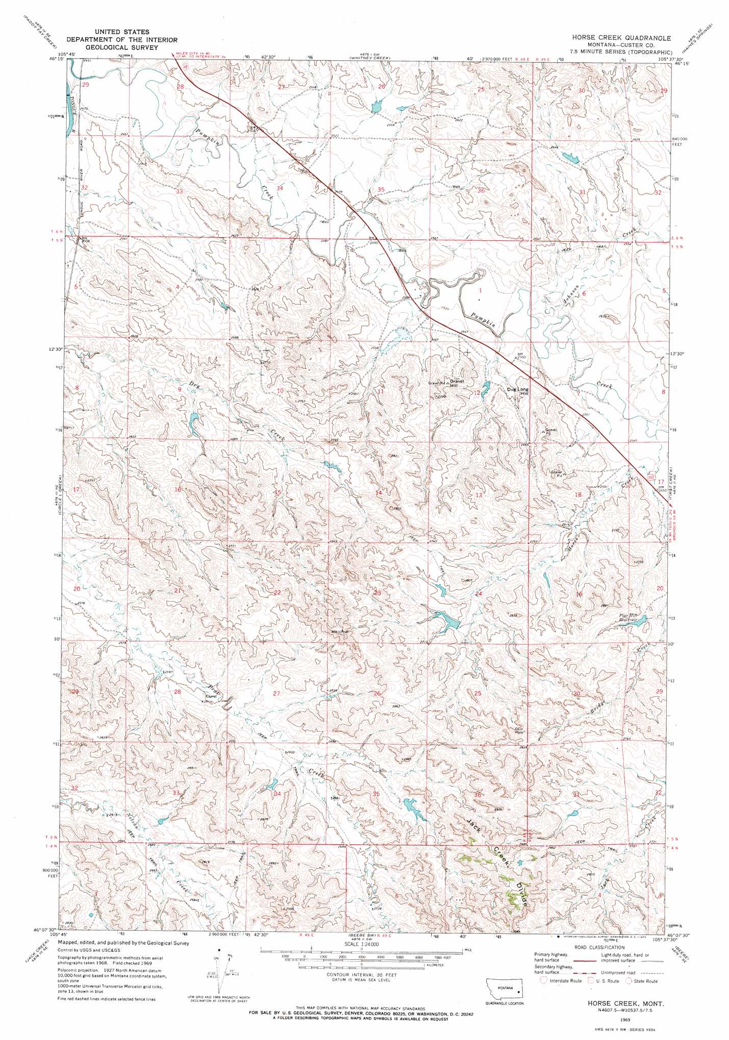
USGS Topo Quad 46105b6 - 1:24,000 scale
| Topo Map Name: | Horse Creek |
| USGS Topo Quad ID: | 46105b6 |
| Print Size: | ca. 21 1/4" wide x 27" high |
| Southeast Coordinates: | 46.125° N latitude / 105.625° W longitude |
| Map Center Coordinates: | 46.1875° N latitude / 105.6875° W longitude |
| U.S. State: | MT |
| Filename: | o46105b6.jpg |
| Download Map JPG Image: | Horse Creek topo map 1:24,000 scale |
| Map Type: | Topographic |
| Topo Series: | 7.5´ |
| Map Scale: | 1:24,000 |
| Source of Map Images: | United States Geological Survey (USGS) |
| Alternate Map Versions: |
Horse Creek MT 1969, updated 1972 Download PDF Buy paper map Horse Creek MT 2011 Download PDF Buy paper map Horse Creek MT 2014 Download PDF Buy paper map |
1:24,000 Topo Quads surrounding Horse Creek
Big Hill |
Miles City |
Government Hill |
The Knob |
Buck Mountain |
Lignite Creek |
Paddy Fay Creek |
Whitney Creek |
Government Hill Se |
Locate Sw |
Jack Creek Nw |
Circle L Creek |
Horse Creek |
First Creek |
Loaf Of Bread Butte |
Garland School |
Jack Creek |
Beebe Sw |
Beebe |
Miles City Creek |
Fourmile Creek |
Carey-Malone School |
Kirkpatrick Hill |
Harris Buttes |
Saddle Horse Butte |
> Back to 46105a1 at 1:100,000 scale
> Back to 46104a1 at 1:250,000 scale
> Back to U.S. Topo Maps home
Horse Creek topo map: Gazetteer
Horse Creek: Dams
Muri Number 4 Dam elevation 801m 2627′Nichols Dam elevation 783m 2568′
Pine Hills Dam elevation 835m 2739′
Rodgers Dam elevation 765m 2509′
Rogers Number 2 Dam elevation 787m 2582′
Horse Creek: Populated Places
Cutler (historical) elevation 755m 2477′Horse Creek: Post Offices
Cutler Post Office (historical) elevation 755m 2477′Horse Creek: Reservoirs
Pine Hill Reservoir elevation 825m 2706′Pine Hills Reservoir elevation 835m 2739′
Horse Creek: Streams
Horse Creek elevation 760m 2493′Johnson Creek elevation 766m 2513′
Horse Creek: Summits
Dug Long Hill elevation 804m 2637′Gravel Hill elevation 823m 2700′
Horse Creek: Wells
04N49E04ABCD01 Well elevation 833m 2732′05N48E02DBDA01 Well elevation 764m 2506′
05N48E28BDBA01 Well elevation 789m 2588′
Horse Creek digital topo map on disk
Buy this Horse Creek topo map showing relief, roads, GPS coordinates and other geographical features, as a high-resolution digital map file on DVD:
Eastern Montana & Western North Dakota
Buy digital topo maps: Eastern Montana & Western North Dakota