Garland School Topo Map Montana
To zoom in, hover over the map of Garland School
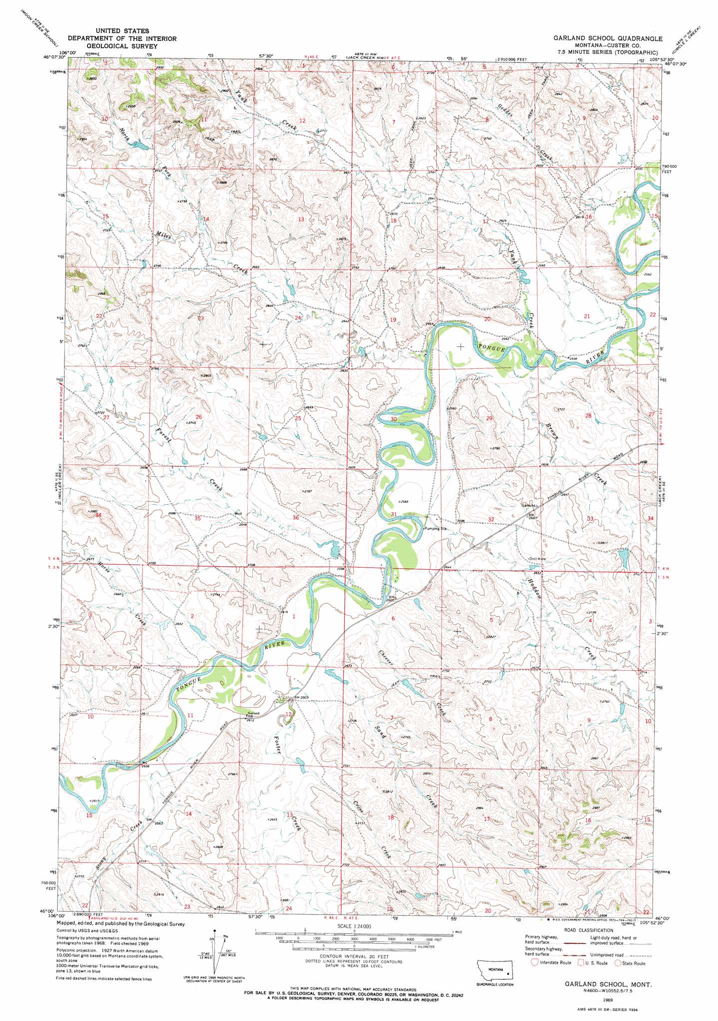
USGS Topo Quad 46105a8 - 1:24,000 scale
| Topo Map Name: | Garland School |
| USGS Topo Quad ID: | 46105a8 |
| Print Size: | ca. 21 1/4" wide x 27" high |
| Southeast Coordinates: | 46° N latitude / 105.875° W longitude |
| Map Center Coordinates: | 46.0625° N latitude / 105.9375° W longitude |
| U.S. State: | MT |
| Filename: | o46105a8.jpg |
| Download Map JPG Image: | Garland School topo map 1:24,000 scale |
| Map Type: | Topographic |
| Topo Series: | 7.5´ |
| Map Scale: | 1:24,000 |
| Source of Map Images: | United States Geological Survey (USGS) |
| Alternate Map Versions: |
Garland School MT 1969, updated 1973 Download PDF Buy paper map Garland School MT 2011 Download PDF Buy paper map Garland School MT 2014 Download PDF Buy paper map |
1:24,000 Topo Quads surrounding Garland School
Hathaway |
Horton |
Lignite Creek |
Paddy Fay Creek |
Whitney Creek |
Miller Creek Nw |
Moon Creek School |
Jack Creek Nw |
Circle L Creek |
Horse Creek |
Miller Creek Sw |
Miller Creek |
Garland School |
Jack Creek |
Beebe Sw |
Brandenberg Nw |
H S School |
Fourmile Creek |
Carey-Malone School |
Kirkpatrick Hill |
Brandenberg |
Hayes Point |
North Stacey School |
Foster Creek School |
Volborg |
> Back to 46105a1 at 1:100,000 scale
> Back to 46104a1 at 1:250,000 scale
> Back to U.S. Topo Maps home
Garland School topo map: Gazetteer
Garland School: Dams
Powell Number 1 Dam elevation 821m 2693′Shipleys Dam elevation 791m 2595′
Garland School: Populated Places
Garland elevation 788m 2585′Garland School: Post Offices
Garland Post Office (historical) elevation 788m 2585′Savage Post Office (historical) elevation 840m 2755′
Garland School: Streams
Brown Creek elevation 775m 2542′Cheever Creek elevation 781m 2562′
Cross Creek elevation 793m 2601′
Forest Creek elevation 780m 2559′
Foster Creek elevation 789m 2588′
Geddes Creek elevation 769m 2522′
Haddow Creek elevation 783m 2568′
Horse Creek elevation 787m 2582′
Jack Creek elevation 773m 2536′
Miles Creek elevation 775m 2542′
North Fork Miles Creek elevation 817m 2680′
Sand Creek elevation 781m 2562′
Stony Creek elevation 794m 2604′
Yank Creek elevation 776m 2545′
Garland School: Wells
03N46E03ADBC01 Well elevation 812m 2664′03N46E11CCDC01 Well elevation 803m 2634′
03N46E12BADA01 Well elevation 790m 2591′
03N46E12BDBC01 Well elevation 790m 2591′
03N47E05AACC01 Well elevation 806m 2644′
03N47E06ABBC01 Well elevation 788m 2585′
03N47E06ABBC02 Well elevation 788m 2585′
04N46E11ADCB01 Well elevation 850m 2788′
04N46E27BDDD01 Well elevation 834m 2736′
04N47E15CBBD01 Well elevation 773m 2536′
04N47E29ABAD01 Well elevation 780m 2559′
04N47E31DAAA01 Well elevation 790m 2591′
Garland School digital topo map on disk
Buy this Garland School topo map showing relief, roads, GPS coordinates and other geographical features, as a high-resolution digital map file on DVD:
Eastern Montana & Western North Dakota
Buy digital topo maps: Eastern Montana & Western North Dakota