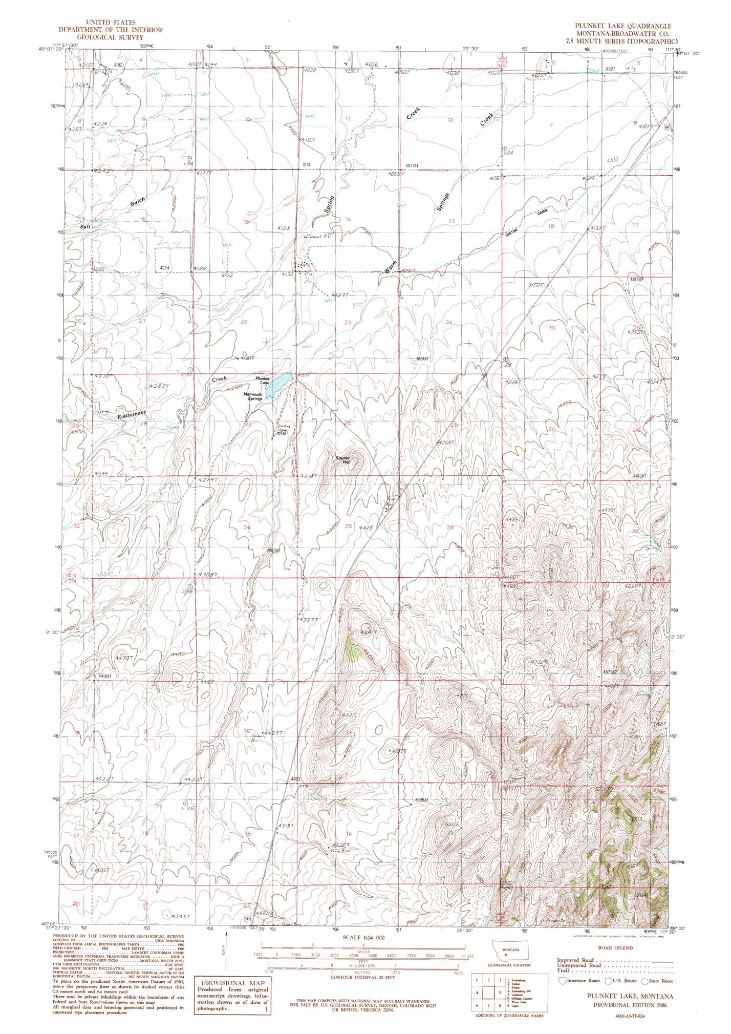
Plunket Lake Topo Map Montana
To zoom in, hover over the map of Plunket Lake
USGS Topo Quad 46111a5 - 1:24,000 scale
| Topo Map Name: | Plunket Lake |
| USGS Topo Quad ID: | 46111a5 |
| Print Size: | ca. 21 1/4" wide x 27" high |
| Southeast Coordinates: | 46° N latitude / 111.5° W longitude |
| Map Center Coordinates: | 46.0625° N latitude / 111.5625° W longitude |
| U.S. State: | MT |
| Filename: | o46111a5.jpg |
| Download Map JPG Image: | Plunket Lake topo map 1:24,000 scale |
| Map Type: | Topographic |
| Topo Series: | 7.5´ |
| Map Scale: | 1:24,000 |
| Source of Map Images: | United States Geological Survey (USGS) |
| Alternate Map Versions: |
Plunket Lake MT 1986, updated 1986 Download PDF Buy paper map Plunket Lake MT 2011 Download PDF Buy paper map Plunket Lake MT 2014 Download PDF Buy paper map |
1:24,000 Topo Quads surrounding Plunket Lake
Crow Creek Falls |
Giant Hill |
Townsend |
Holker |
Lippert Gulch |
Devils Fence |
Radersburg |
Parker |
Toston |
Deer Park |
Willow Springs |
Radersburg Sw |
Plunket Lake |
Lombard |
Roy Gulch |
Negro Hollow |
Milligan Canyon |
Three Forks |
Logan |
Nixon Gulch |
Sappington |
Willow Creek |
Three Forks Se |
Manhattan Sw |
Manhattan |
> Back to 46111a1 at 1:100,000 scale
> Back to 46110a1 at 1:250,000 scale
> Back to U.S. Topo Maps home
Plunket Lake topo map: Gazetteer
Plunket Lake: Dams
Plunket Lake Dam elevation 1269m 4163′Plunket Lake: Post Offices
McIntire Post Office (historical) elevation 1354m 4442′Plunket Lake: Reservoirs
Plunket Lake elevation 1270m 4166′Plunket Lake: Springs
04N01E12DC__01 Spring elevation 1238m 4061′04N01E27ABDD01 Spring elevation 1272m 4173′
Mammoth Springs elevation 1275m 4183′
Plunket Lake: Summits
Chewh-toowh-too-peh Hill elevation 1347m 4419′Plunket Lake: Valleys
Salt Gulch elevation 1280m 4199′Plunket Lake: Wells
04N01E02CCCB01 Well elevation 1247m 4091′04N01E02DD__01 Well elevation 1236m 4055′
04N01E02DD__02 Well elevation 1236m 4055′
04N01E02DD__03 Well elevation 1236m 4055′
04N01E09ADB_01 Well elevation 1275m 4183′
04N01E09CAB_01 Well elevation 1259m 4130′
04N01E10AA__01 Well elevation 1250m 4101′
04N01E10BBCB01 Well elevation 1266m 4153′
04N01E10BCCC01 Well elevation 1266m 4153′
04N01E10CB__01 Well elevation 1267m 4156′
04N01E11AB__01 Well elevation 1239m 4064′
04N01E11BCCB01 Well elevation 1249m 4097′
04N01E11CBDD01 Well elevation 1246m 4087′
04N01E12AA__01 Well elevation 1232m 4041′
04N01E12BADD01 Well elevation 1233m 4045′
04N01E12BD__01 Well elevation 1235m 4051′
04N01E13BCBC01 Well elevation 1245m 4084′
04N01E13CC__01 Well elevation 1249m 4097′
04N01E14CC__01 Well elevation 1256m 4120′
04N01E15BCBB01 Well elevation 1277m 4189′
04N01E15CDBA01 Well elevation 1266m 4153′
04N01E16DA__01 Well elevation 1281m 4202′
04N01E22CB__01 Well elevation 1282m 4206′
04N01E23BAC_01 Well elevation 1260m 4133′
04N01E23BBB_01 Well elevation 1263m 4143′
04N02E05CC__01 Well elevation 1226m 4022′
04N02E05CDDC01 Well elevation 1233m 4045′
04N02E06CC__01 Well elevation 1228m 4028′
04N02E06CD__01 Well elevation 1227m 4025′
04N02E06DD__01 Well elevation 1225m 4019′
04N02E08BB__01 Well elevation 1232m 4041′
04N02E08BB__02 Well elevation 1232m 4041′
04N02E18ACAC01 Well elevation 1253m 4110′
Plunket Lake digital topo map on disk
Buy this Plunket Lake topo map showing relief, roads, GPS coordinates and other geographical features, as a high-resolution digital map file on DVD: