Fail Ranch Topo Map Montana
To zoom in, hover over the map of Fail Ranch
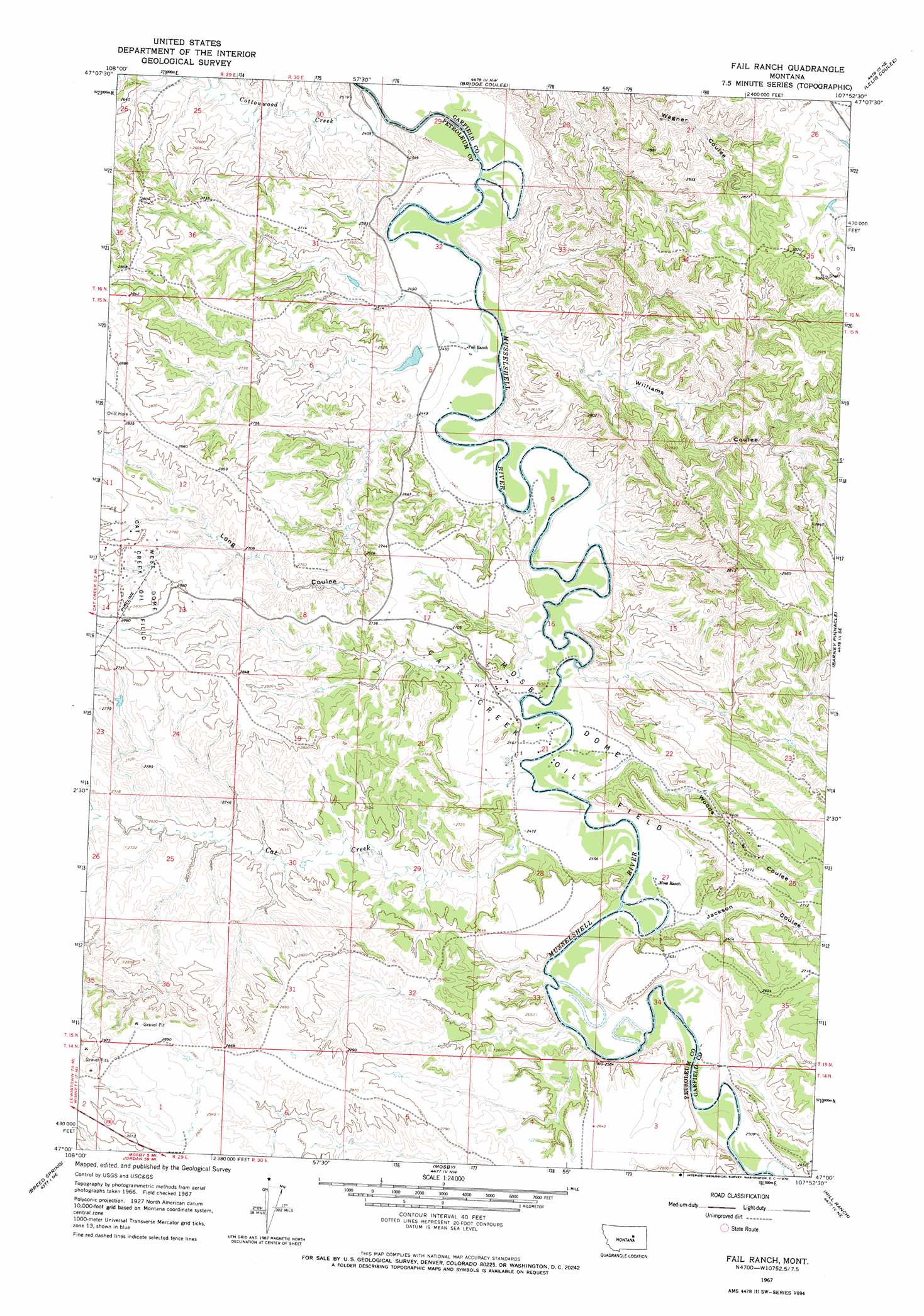
USGS Topo Quad 47107a8 - 1:24,000 scale
| Topo Map Name: | Fail Ranch |
| USGS Topo Quad ID: | 47107a8 |
| Print Size: | ca. 21 1/4" wide x 27" high |
| Southeast Coordinates: | 47° N latitude / 107.875° W longitude |
| Map Center Coordinates: | 47.0625° N latitude / 107.9375° W longitude |
| U.S. State: | MT |
| Filename: | o47107a8.jpg |
| Download Map JPG Image: | Fail Ranch topo map 1:24,000 scale |
| Map Type: | Topographic |
| Topo Series: | 7.5´ |
| Map Scale: | 1:24,000 |
| Source of Map Images: | United States Geological Survey (USGS) |
| Alternate Map Versions: |
Fail Ranch MT 1967, updated 1970 Download PDF Buy paper map Fail Ranch MT 2011 Download PDF Buy paper map Fail Ranch MT 2014 Download PDF Buy paper map |
1:24,000 Topo Quads surrounding Fail Ranch
Davis Spring |
Kirkendal Flat |
Nelson Coulee |
Seventynine Coulee |
Benzien |
Cat Creek Nw |
Tin Can Hill |
Bridge Coulee |
Lelig Coulee |
Searl Coulee |
Ingals Dam |
Cat Creek |
Fail Ranch |
Barney Pinnacle |
Froehlich Butte |
Petrolia Lake |
Breed Spring |
Mosby |
Hill Ranch |
Dutton Ranch |
Kelley |
Mud Spring |
Maxwell Ranch |
Mosby Se |
Kincheloe Ranch |
> Back to 47107a1 at 1:100,000 scale
> Back to 47106a1 at 1:250,000 scale
> Back to U.S. Topo Maps home
Fail Ranch topo map: Gazetteer
Fail Ranch: Dams
US Number 44 Dam elevation 755m 2477′Fail Ranch: Oilfields
Mosby Dome Cat Creek Oil Field elevation 749m 2457′West Dome Cat Creek Oil Field elevation 845m 2772′
Fail Ranch: Streams
Cat Creek elevation 750m 2460′Cottonwood Creek elevation 736m 2414′
Sage Hen Creek elevation 763m 2503′
Fail Ranch: Valleys
Jackson Coulee elevation 766m 2513′Long Coulee elevation 745m 2444′
Williams Coulee elevation 741m 2431′
Woods Coulee elevation 759m 2490′
Fail Ranch: Wells
15N29E11DD__01 Well elevation 856m 2808′15N30E21BAC_01 Well elevation 756m 2480′
15N30E27CAAA01 Well elevation 754m 2473′
Fail Ranch digital topo map on disk
Buy this Fail Ranch topo map showing relief, roads, GPS coordinates and other geographical features, as a high-resolution digital map file on DVD:
Eastern Montana & Western North Dakota
Buy digital topo maps: Eastern Montana & Western North Dakota