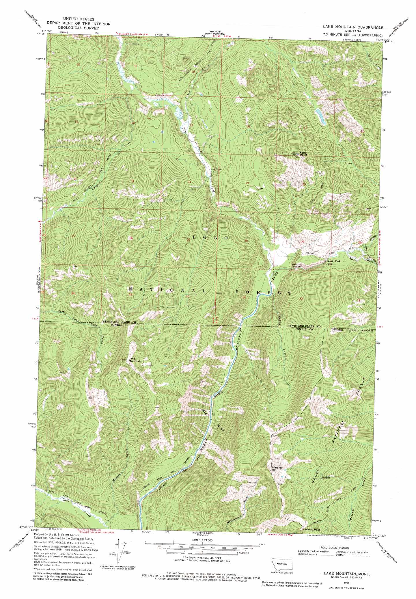
Lake Mountain Topo Map Montana
To zoom in, hover over the map of Lake Mountain
USGS Topo Quad 47112b8 - 1:24,000 scale
| Topo Map Name: | Lake Mountain |
| USGS Topo Quad ID: | 47112b8 |
| Print Size: | ca. 21 1/4" wide x 27" high |
| Southeast Coordinates: | 47.125° N latitude / 112.875° W longitude |
| Map Center Coordinates: | 47.1875° N latitude / 112.9375° W longitude |
| U.S. State: | MT |
| Filename: | o47112b8.jpg |
| Download Map JPG Image: | Lake Mountain topo map 1:24,000 scale |
| Map Type: | Topographic |
| Topo Series: | 7.5´ |
| Map Scale: | 1:24,000 |
| Source of Map Images: | United States Geological Survey (USGS) |
| Alternate Map Versions: |
Lake Mountain MT 1968, updated 1971 Download PDF Buy paper map Lake Mountain MT 1968, updated 1981 Download PDF Buy paper map Lake Mountain MT 1999, updated 2003 Download PDF Buy paper map Lake Mountain MT 2011 Download PDF Buy paper map Lake Mountain MT 2014 Download PDF Buy paper map |
| FStopo: | US Forest Service topo Lake Mountain is available: Download FStopo PDF Download FStopo TIF |
1:24,000 Topo Quads surrounding Lake Mountain
Pilot Peak |
Trap Mountain |
Benchmark |
Wood Lake |
Double Falls |
Hahn Creek Pass |
Danaher Mountain |
Flint Mountain |
Scapegoat Mountain |
Jakie Creek |
Dunham Point |
Spread Mountain |
Lake Mountain |
Olson Peak |
Heart Lake |
Ovando |
Ovando Mountain |
Coopers Lake |
Arrastra Mountain |
Stonewall Mountain |
Chamberlain Mountain |
Browns Lake |
Marcum Mountain |
Moose Creek |
Lincoln |
> Back to 47112a1 at 1:100,000 scale
> Back to 47112a1 at 1:250,000 scale
> Back to U.S. Topo Maps home
Lake Mountain topo map: Gazetteer
Lake Mountain: Cliffs
Big Slide elevation 1507m 4944′Lake Mountain: Falls
North Fork Falls elevation 1648m 5406′Lake Mountain: Gaps
Windy Pass elevation 2116m 6942′Lake Mountain: Mines
SE Section 5 Mine elevation 2295m 7529′Lake Mountain: Streams
Cabin Creek elevation 1588m 5209′Canyon Creek elevation 1599m 5246′
Dry Fork North Fork Blackfoot River elevation 1538m 5045′
East Fork North Fork Blackfoot River elevation 1655m 5429′
Jakey Creek elevation 1537m 5042′
Madison Creek elevation 1458m 4783′
Lake Mountain: Summits
Falls Point elevation 2292m 7519′Lake Mountain elevation 2544m 8346′
Mineral Hill elevation 2514m 8248′
Lake Mountain: Swamps
Sourdough Flats elevation 1543m 5062′Lake Mountain: Trails
McDermott Trail elevation 1494m 4901′North Fork Trail elevation 1656m 5433′
Lake Mountain digital topo map on disk
Buy this Lake Mountain topo map showing relief, roads, GPS coordinates and other geographical features, as a high-resolution digital map file on DVD: