Emida Topo Map Idaho
To zoom in, hover over the map of Emida
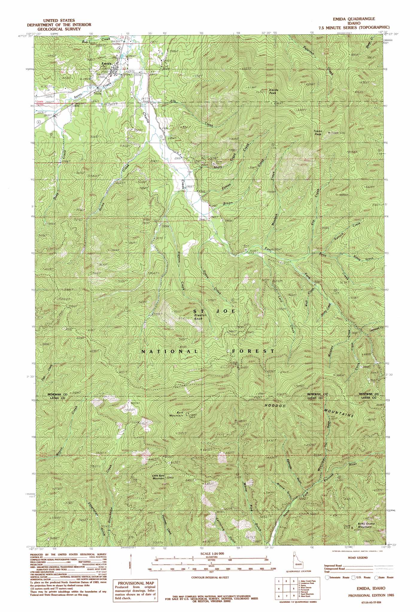
USGS Topo Quad 47116a5 - 1:24,000 scale
| Topo Map Name: | Emida |
| USGS Topo Quad ID: | 47116a5 |
| Print Size: | ca. 21 1/4" wide x 27" high |
| Southeast Coordinates: | 47° N latitude / 116.5° W longitude |
| Map Center Coordinates: | 47.0625° N latitude / 116.5625° W longitude |
| U.S. State: | ID |
| Filename: | o47116a5.jpg |
| Download Map JPG Image: | Emida topo map 1:24,000 scale |
| Map Type: | Topographic |
| Topo Series: | 7.5´ |
| Map Scale: | 1:24,000 |
| Source of Map Images: | United States Geological Survey (USGS) |
| Alternate Map Versions: |
Emida ID 1985, updated 1985 Download PDF Buy paper map Emida ID 1994, updated 1997 Download PDF Buy paper map Emida ID 2011 Download PDF Buy paper map Emida ID 2014 Download PDF Buy paper map |
| FStopo: | US Forest Service topo Emida is available: Download FStopo PDF Download FStopo TIF |
1:24,000 Topo Quads surrounding Emida
Chatcolet |
Benewah Lake |
Saint Maries |
Saint Joe Baldy |
Saint Joe |
Benewah |
Alder Creek Flats |
Lindstrom Peak |
Santa |
Crystal Peak |
Sanders |
West Dennis |
Emida |
Fernwood |
Clarkia |
Princeton |
Harvard |
Sand Mountain |
Abes Knob |
Bechtel Butte |
Moscow Mountain |
Stanford |
Deary |
Bovill |
Mcgary Butte |
> Back to 47116a1 at 1:100,000 scale
> Back to 47116a1 at 1:250,000 scale
> Back to U.S. Topo Maps home
Emida topo map: Gazetteer
Emida: Populated Places
Emida elevation 869m 2851′Emida: Streams
Bob Creek elevation 867m 2844′Brown Creek elevation 898m 2946′
Charlie Creek elevation 865m 2837′
Corto Creek elevation 1048m 3438′
Deep Creek elevation 866m 2841′
East Fork Charlie Creek elevation 885m 2903′
East Fork Meadow Creek elevation 1091m 3579′
Eena Creek elevation 947m 3106′
Elip Creek elevation 989m 3244′
Ells Creek elevation 867m 2844′
Fagan Creek elevation 900m 2952′
Hume Creek elevation 870m 2854′
Katsuck Creek elevation 1003m 3290′
Kimta Creek elevation 1022m 3353′
Lacy Creek elevation 921m 3021′
Lemoosh Creek elevation 1057m 3467′
Melakwa Creek elevation 1025m 3362′
Moolock Creek elevation 930m 3051′
Pamas Creek elevation 892m 2926′
Preston Creek elevation 912m 2992′
Scurry Creek elevation 1010m 3313′
Short Creek elevation 885m 2903′
Wadi Creek elevation 966m 3169′
Emida: Summits
Baby Grand Mountain elevation 1429m 4688′Bald Mountain elevation 1622m 5321′
Emida Peak elevation 1384m 4540′
Little Bald Mountain elevation 1479m 4852′
Preston Knob elevation 1254m 4114′
Tyson Peak elevation 1425m 4675′
Emida: Valleys
Eldorado Gulch elevation 1018m 3339′Moscow Gulch elevation 1029m 3375′
Mountain Gulch elevation 1096m 3595′
White Pine Gulch elevation 972m 3188′
Emida digital topo map on disk
Buy this Emida topo map showing relief, roads, GPS coordinates and other geographical features, as a high-resolution digital map file on DVD: