Chief Joseph Dam Topo Map Washington
To zoom in, hover over the map of Chief Joseph Dam
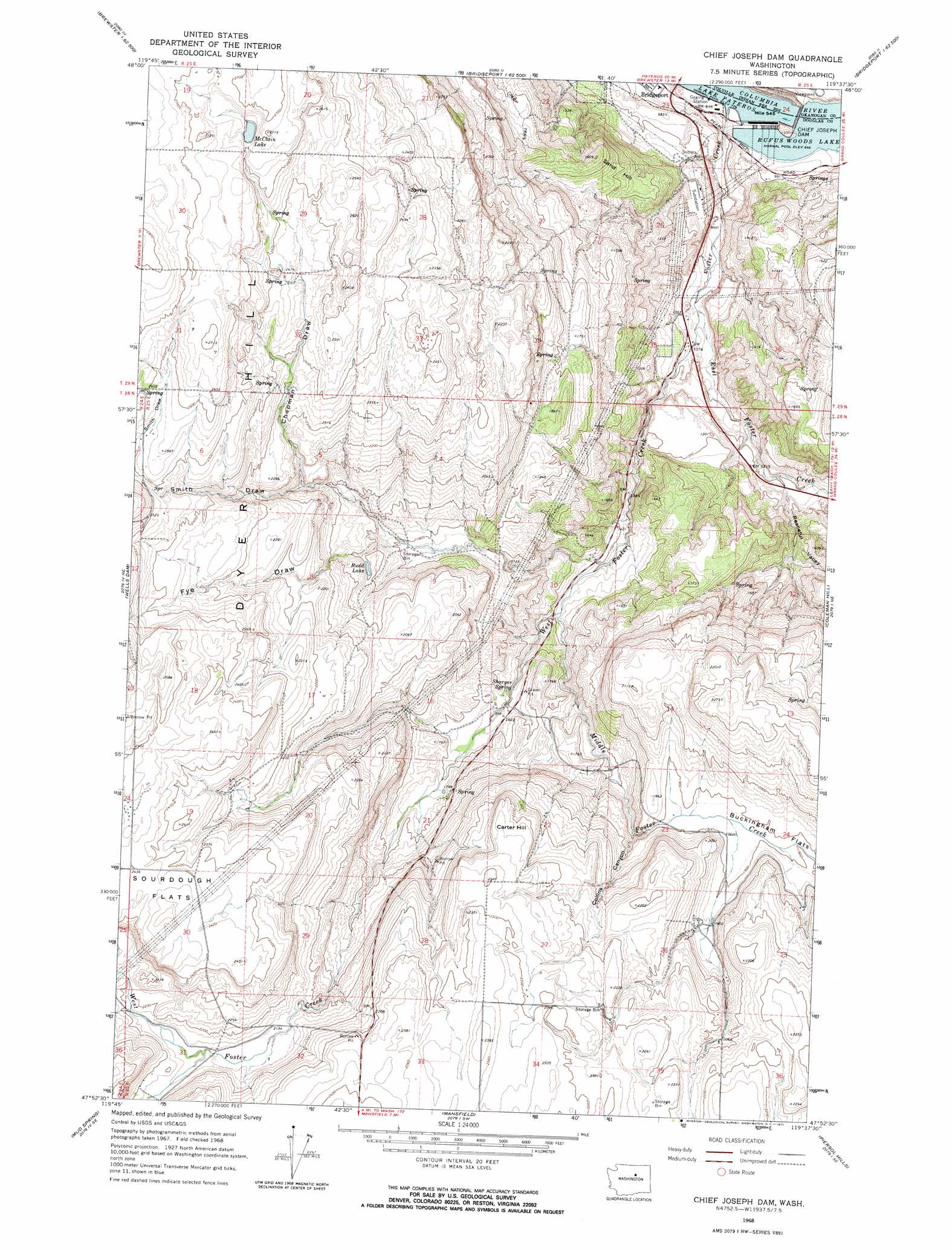
USGS Topo Quad 47119h6 - 1:24,000 scale
| Topo Map Name: | Chief Joseph Dam |
| USGS Topo Quad ID: | 47119h6 |
| Print Size: | ca. 21 1/4" wide x 27" high |
| Southeast Coordinates: | 47.875° N latitude / 119.625° W longitude |
| Map Center Coordinates: | 47.9375° N latitude / 119.6875° W longitude |
| U.S. State: | WA |
| Filename: | o47119h6.jpg |
| Download Map JPG Image: | Chief Joseph Dam topo map 1:24,000 scale |
| Map Type: | Topographic |
| Topo Series: | 7.5´ |
| Map Scale: | 1:24,000 |
| Source of Map Images: | United States Geological Survey (USGS) |
| Alternate Map Versions: |
Chief Joseph Dam WA 1968, updated 1971 Download PDF Buy paper map Chief Joseph Dam WA 2011 Download PDF Buy paper map Chief Joseph Dam WA 2014 Download PDF Buy paper map |
1:24,000 Topo Quads surrounding Chief Joseph Dam
Knowton Knob |
Rat Lake |
Monse |
White Lakes |
Joe Lake |
Pateros |
Brewster |
Bridgeport |
Bridgeport Point |
Stubblefield Point |
Azwell |
Wells Dam |
Chief Joseph Dam |
Coleman Hill |
Leahy |
Chelan Falls |
Mud Spring |
Mansfield |
Piersol Hills |
Barnes Butte |
Lamoine |
Withrow |
Jameson Lake West |
Jameson Lake East |
Saint Andrews |
> Back to 47119e1 at 1:100,000 scale
> Back to 47118a1 at 1:250,000 scale
> Back to U.S. Topo Maps home
Chief Joseph Dam topo map: Gazetteer
Chief Joseph Dam: Capes
Carter Hill elevation 683m 2240′Chief Joseph Dam: Dams
Chief Joseph Dam elevation 271m 889′Chief Joseph Dam: Flats
Buckingham Flats elevation 581m 1906′Chief Joseph Dam: Lakes
McClain Lake elevation 788m 2585′Rudd Lake elevation 580m 1902′
Chief Joseph Dam: Parks
Foster Creek Wildlife Recreation Area elevation 549m 1801′Chief Joseph Dam: Reservoirs
Rufus Woods Lake elevation 271m 889′Chief Joseph Dam: Springs
Sharyer Spring elevation 487m 1597′Chief Joseph Dam: Streams
East Foster Creek elevation 312m 1023′Foster Creek elevation 247m 810′
Middle Foster Creek elevation 448m 1469′
West Foster Creek elevation 312m 1023′
Chief Joseph Dam: Summits
Sand Hill elevation 476m 1561′Chief Joseph Dam: Valleys
Chapman Draw elevation 635m 2083′Collins Canyon elevation 541m 1774′
Fye Draw elevation 548m 1797′
Peaceful Valley elevation 365m 1197′
Smith Draw elevation 427m 1400′
Chief Joseph Dam digital topo map on disk
Buy this Chief Joseph Dam topo map showing relief, roads, GPS coordinates and other geographical features, as a high-resolution digital map file on DVD: