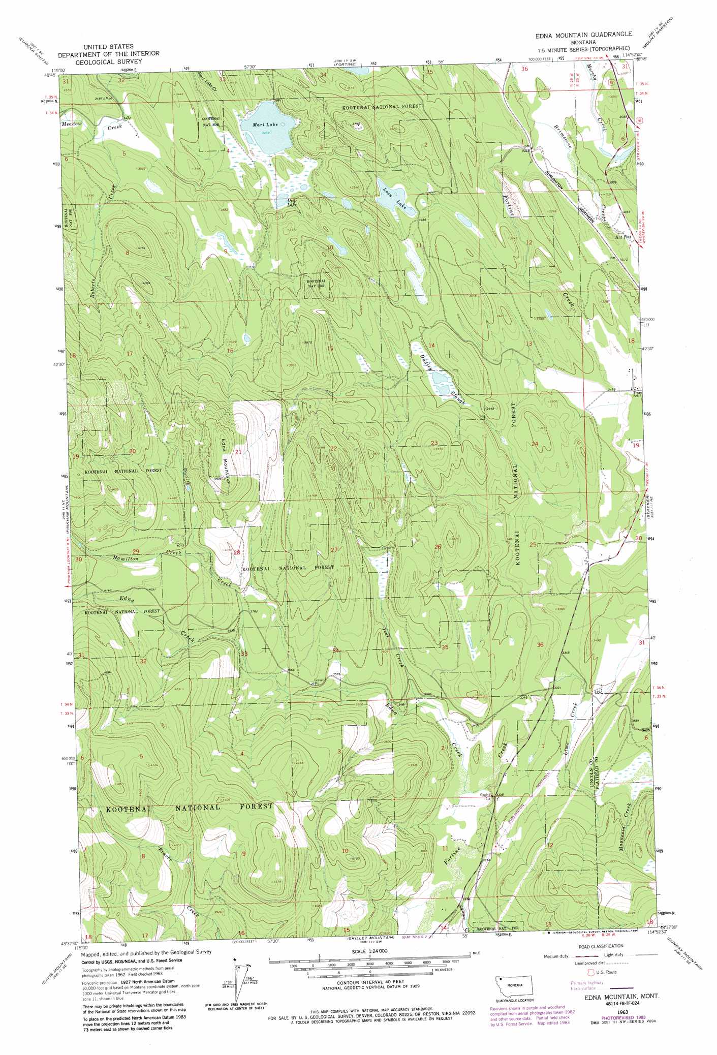
Edna Mountain Topo Map Montana
To zoom in, hover over the map of Edna Mountain
USGS Topo Quad 48114f8 - 1:24,000 scale
| Topo Map Name: | Edna Mountain |
| USGS Topo Quad ID: | 48114f8 |
| Print Size: | ca. 21 1/4" wide x 27" high |
| Southeast Coordinates: | 48.625° N latitude / 114.875° W longitude |
| Map Center Coordinates: | 48.6875° N latitude / 114.9375° W longitude |
| U.S. State: | MT |
| Filename: | o48114f8.jpg |
| Download Map JPG Image: | Edna Mountain topo map 1:24,000 scale |
| Map Type: | Topographic |
| Topo Series: | 7.5´ |
| Map Scale: | 1:24,000 |
| Source of Map Images: | United States Geological Survey (USGS) |
| Alternate Map Versions: |
Edna Mountain MT 1963, updated 1966 Download PDF Buy paper map Edna Mountain MT 1963, updated 1984 Download PDF Buy paper map Edna Mountain MT 1997, updated 2000 Download PDF Buy paper map Edna Mountain MT 2011 Download PDF Buy paper map Edna Mountain MT 2014 Download PDF Buy paper map |
| FStopo: | US Forest Service topo Edna Mountain is available: Download FStopo PDF Download FStopo TIF |
1:24,000 Topo Quads surrounding Edna Mountain
Rexford |
Eureka North |
Ksanka Peak |
Stahl Peak |
Tuchuck Mountain |
Beartrap Mountain |
Eureka South |
Fortine |
Mount Marston |
Mount Thompson-Seton |
Mcguire Mountain |
Pinkham Mountain |
Edna Mountain |
Stryker |
Bull Lake |
Volcour |
Davis Mountain |
Skillet Mountain |
Sunday Mountain |
Radnor |
Cripple Horse Mountain |
Warland Peak |
Bowen Lake |
Dunsire Point |
Johnson Peak |
> Back to 48114e1 at 1:100,000 scale
> Back to 48114a1 at 1:250,000 scale
> Back to U.S. Topo Maps home
Edna Mountain topo map: Gazetteer
Edna Mountain: Lakes
Deep Lake elevation 1010m 3313′Loon Lake elevation 996m 3267′
Marl Lake elevation 1001m 3284′
Edna Mountain: Populated Places
Ant Flat elevation 926m 3038′Edna Mountain: Streams
Brimstone Creek elevation 906m 2972′Dudley Creek elevation 1104m 3622′
Edna Creek elevation 1013m 3323′
Hamilton Creek elevation 1188m 3897′
Ivor Creek elevation 1025m 3362′
Lime Creek elevation 1011m 3316′
Magnesia Creek elevation 1068m 3503′
Roberts Creek elevation 1047m 3435′
Stewart Creek elevation 1020m 3346′
Edna Mountain: Summits
Edna Mountain elevation 1404m 4606′Edna Mountain: Swamps
Dudley Slough elevation 1031m 3382′Edna Mountain: Wells
34N25W07ACDB01 Well elevation 933m 3061′34N25W30BD__01 Well elevation 979m 3211′
34N25W30CAAA01 Well elevation 985m 3231′
34N26W04ACDB01 Well elevation 1001m 3284′
34N26W25DDAD01 Well elevation 1000m 3280′
Edna Mountain digital topo map on disk
Buy this Edna Mountain topo map showing relief, roads, GPS coordinates and other geographical features, as a high-resolution digital map file on DVD: