Conconully West Topo Map Washington
To zoom in, hover over the map of Conconully West
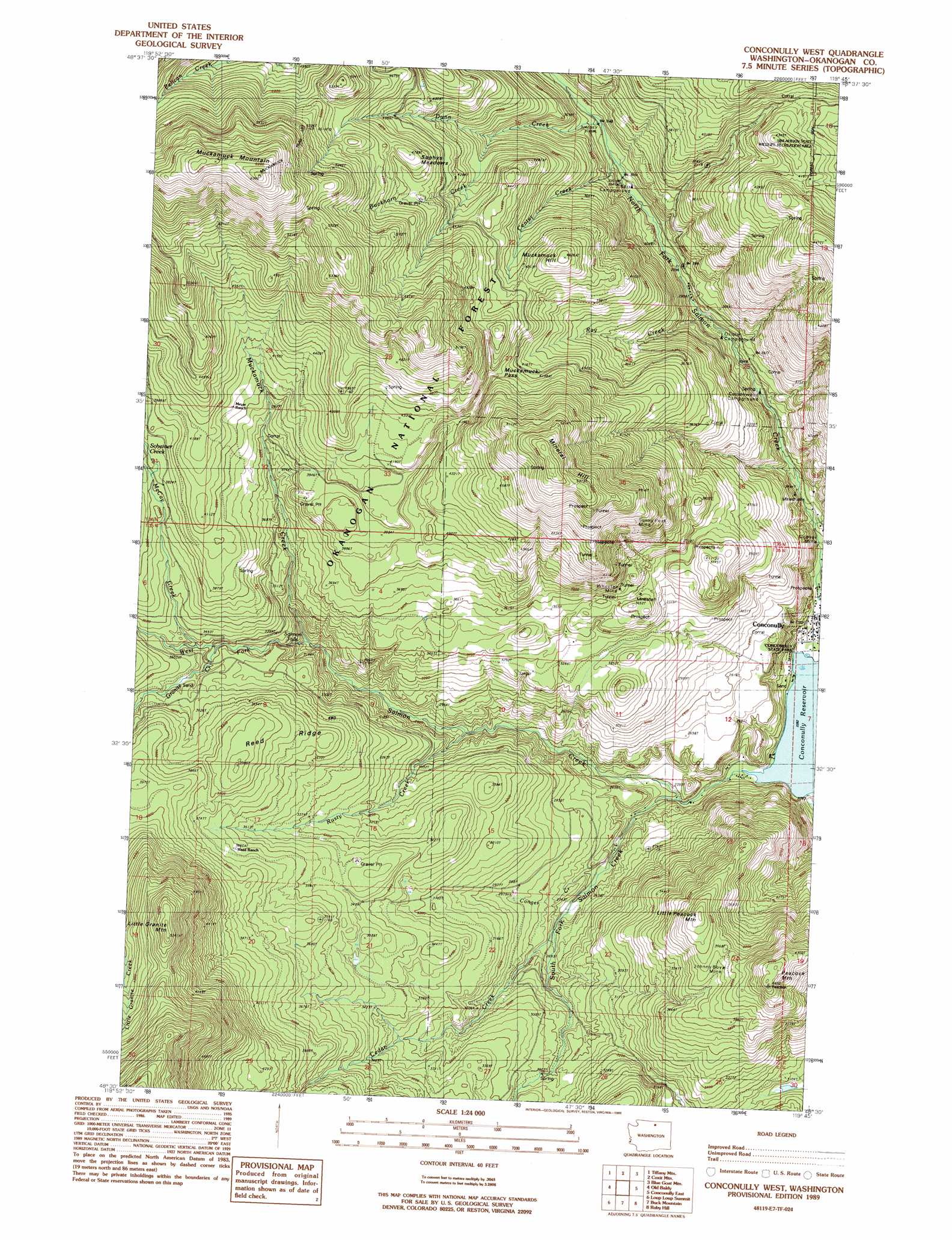
USGS Topo Quad 48119e7 - 1:24,000 scale
| Topo Map Name: | Conconully West |
| USGS Topo Quad ID: | 48119e7 |
| Print Size: | ca. 21 1/4" wide x 27" high |
| Southeast Coordinates: | 48.5° N latitude / 119.75° W longitude |
| Map Center Coordinates: | 48.5625° N latitude / 119.8125° W longitude |
| U.S. State: | WA |
| Filename: | o48119e7.jpg |
| Download Map JPG Image: | Conconully West topo map 1:24,000 scale |
| Map Type: | Topographic |
| Topo Series: | 7.5´ |
| Map Scale: | 1:24,000 |
| Source of Map Images: | United States Geological Survey (USGS) |
| Alternate Map Versions: |
Conconully West WA 1989, updated 1989 Download PDF Buy paper map Conconully West WA 2011 Download PDF Buy paper map Conconully West WA 2014 Download PDF Buy paper map |
| FStopo: | US Forest Service topo Conconully West is available: Download FStopo PDF Download FStopo TIF |
1:24,000 Topo Quads surrounding Conconully West
Coleman Peak |
Corral Butte |
Duncan Ridge |
Loomis |
Enterprise |
Spur Peak |
Tiffany Mountain |
Coxit Mountain |
Blue Goat Mountain |
Aeneas Lake |
Pearrygin Peak |
Old Baldy |
Conconully West |
Conconully East |
Riverside |
Blue Buck Mountain |
Loup Loup Summit |
Buck Mountain |
Ruby Hill |
Omak |
Twisp East |
Thrapp Mountain |
Chiliwist Valley |
Malott |
Okanogan |
> Back to 48119e1 at 1:100,000 scale
> Back to 48118a1 at 1:250,000 scale
> Back to U.S. Topo Maps home
Conconully West topo map: Gazetteer
Conconully West: Falls
Salmon Falls elevation 967m 3172′Conconully West: Gaps
Muckamuck Pass elevation 1330m 4363′Conconully West: Mines
Gubser Mine elevation 734m 2408′Johnny Boy Mine elevation 1195m 3920′
Sunny Peak Mine elevation 1353m 4438′
Wheeler Mine elevation 1132m 3713′
Conconully West: Parks
Conconully State Park elevation 697m 2286′Conconully West: Ranges
Sophys Meadows elevation 1445m 4740′Conconully West: Ridges
Reed Ridge elevation 1127m 3697′Conconully West: Streams
Buckhorn Creek elevation 1125m 3690′Cedar Creek elevation 812m 2664′
Center Creek elevation 945m 3100′
Conger Creek elevation 788m 2585′
Dunn Creek elevation 986m 3234′
First Creek elevation 909m 2982′
Granite Creek elevation 1025m 3362′
McCay Creek elevation 1038m 3405′
Muckamuck Creek elevation 921m 3021′
Ray Creek elevation 872m 2860′
Rusty Creek elevation 831m 2726′
Scheiner Creek elevation 1167m 3828′
South Fork Salmon Creek elevation 727m 2385′
West Fork Salmon Creek elevation 697m 2286′
Conconully West: Summits
Little Granite Mountain elevation 1614m 5295′Little Peacock Mountain elevation 1261m 4137′
Mineral Hill elevation 1674m 5492′
Muckamuck Hill elevation 1402m 4599′
Muckamuck Mountain elevation 1935m 6348′
Peacock Mountain elevation 1354m 4442′
Conconully West: Trails
Funk Mountain Trail (historical) elevation 1229m 4032′Granite Trail elevation 1434m 4704′
Ray Trail (historical) elevation 1327m 4353′
Tunnel Trail elevation 1559m 5114′
Conconully West digital topo map on disk
Buy this Conconully West topo map showing relief, roads, GPS coordinates and other geographical features, as a high-resolution digital map file on DVD: