Verlot Topo Map Washington
To zoom in, hover over the map of Verlot
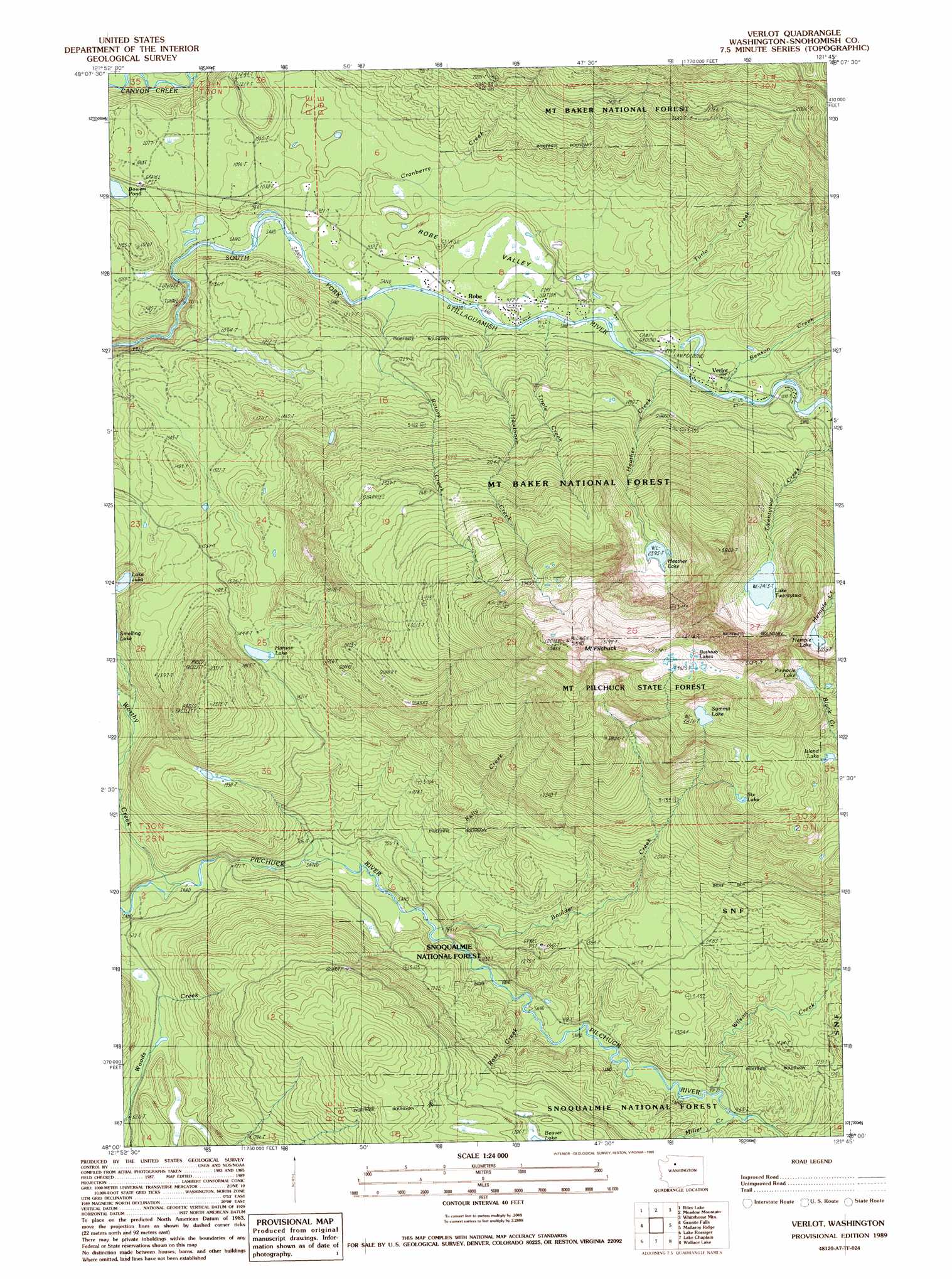
USGS Topo Quad 48121a7 - 1:24,000 scale
| Topo Map Name: | Verlot |
| USGS Topo Quad ID: | 48121a7 |
| Print Size: | ca. 21 1/4" wide x 27" high |
| Southeast Coordinates: | 48° N latitude / 121.75° W longitude |
| Map Center Coordinates: | 48.0625° N latitude / 121.8125° W longitude |
| U.S. State: | WA |
| Filename: | o48121a7.jpg |
| Download Map JPG Image: | Verlot topo map 1:24,000 scale |
| Map Type: | Topographic |
| Topo Series: | 7.5´ |
| Map Scale: | 1:24,000 |
| Source of Map Images: | United States Geological Survey (USGS) |
| Alternate Map Versions: |
Verlot WA 1989, updated 1989 Download PDF Buy paper map Verlot WA 1989, updated 1989 Download PDF Buy paper map Verlot WA 2011 Download PDF Buy paper map Verlot WA 2014 Download PDF Buy paper map |
| FStopo: | US Forest Service topo Verlot is available: Download FStopo PDF Download FStopo TIF |
1:24,000 Topo Quads surrounding Verlot
Stimson Hill |
Oso |
Mount Higgins |
Fortson |
Darrington |
Arlington East |
Riley Lake |
Meadow Mountain |
Whitehorse Mountain |
Helena Ridge |
Lake Stevens |
Granite Falls |
Verlot |
Mallardy Ridge |
Silverton |
Snohomish |
Lake Roesiger |
Lake Chaplain |
Wallace Lake |
Mount Stickney |
Maltby |
Monroe |
Sultan |
Gold Bar |
Index |
> Back to 48121a1 at 1:100,000 scale
> Back to 48120a1 at 1:250,000 scale
> Back to U.S. Topo Maps home
Verlot topo map: Gazetteer
Verlot: Areas
Lake Twentytwo Research Natural Area elevation 747m 2450′Verlot: Lakes
Bathtub Lakes elevation 1441m 4727′Beaver Lake elevation 522m 1712′
Bowers Lake elevation 291m 954′
Hanson Lake elevation 437m 1433′
Heather Lake elevation 731m 2398′
Hempel Lake elevation 945m 3100′
Island Lake elevation 1068m 3503′
Lake Julia elevation 292m 958′
Lake Twentytwo elevation 737m 2417′
Pinnacle Lake elevation 1152m 3779′
Six Lake elevation 1045m 3428′
Summit Lake elevation 1183m 3881′
Verlot: Parks
Mount Pilchuck State Forest elevation 1456m 4776′Verlot: Populated Places
Robe elevation 275m 902′Verlot elevation 294m 964′
Verlot: Streams
Benson Creek elevation 293m 961′Boulder Creek elevation 239m 784′
Cranberry Creek elevation 266m 872′
Hawthorn Creek elevation 277m 908′
Heather Creek elevation 290m 951′
Kelly Creek elevation 212m 695′
Miller Creek elevation 294m 964′
Ross Creek elevation 267m 875′
Rotary Creek elevation 272m 892′
Triple Creek elevation 280m 918′
Turlo Creek elevation 293m 961′
Twentytwo Creek elevation 319m 1046′
Wilson Creek elevation 294m 964′
Worthy Creek elevation 175m 574′
Verlot: Summits
Mount Pilchuck elevation 1584m 5196′Verlot: Trails
Echo Lake Truck Trail elevation 552m 1811′Verlot digital topo map on disk
Buy this Verlot topo map showing relief, roads, GPS coordinates and other geographical features, as a high-resolution digital map file on DVD: