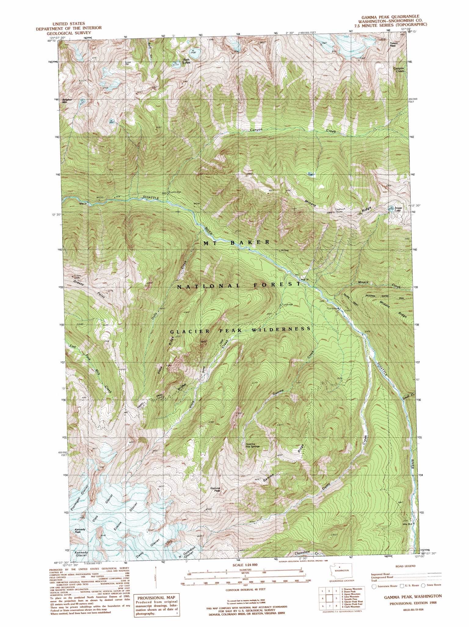
Gamma Peak Topo Map Washington
To zoom in, hover over the map of Gamma Peak
USGS Topo Quad 48121b1 - 1:24,000 scale
| Topo Map Name: | Gamma Peak |
| USGS Topo Quad ID: | 48121b1 |
| Print Size: | ca. 21 1/4" wide x 27" high |
| Southeast Coordinates: | 48.125° N latitude / 121° W longitude |
| Map Center Coordinates: | 48.1875° N latitude / 121.0625° W longitude |
| U.S. State: | WA |
| Filename: | o48121b1.jpg |
| Download Map JPG Image: | Gamma Peak topo map 1:24,000 scale |
| Map Type: | Topographic |
| Topo Series: | 7.5´ |
| Map Scale: | 1:24,000 |
| Source of Map Images: | United States Geological Survey (USGS) |
| Alternate Map Versions: |
Gamma Peak WA 1988, updated 1988 Download PDF Buy paper map Gamma Peak WA 1988, updated 1988 Download PDF Buy paper map Gamma Peak WA 1999, updated 2002 Download PDF Buy paper map Gamma Peak WA 2011 Download PDF Buy paper map Gamma Peak WA 2014 Download PDF Buy paper map |
| FStopo: | US Forest Service topo Gamma Peak is available: Download FStopo PDF Download FStopo TIF |
1:24,000 Topo Quads surrounding Gamma Peak
Snowking Mountain |
Sonny Boy Lakes |
Cascade Pass |
Goode Mountain |
Mcgregor Mountain |
Huckleberry Mountain |
Downey Mountain |
Dome Peak |
Agnes Mountain |
Mount Lyall |
Pugh Mountain |
Lime Mountain |
Gamma Peak |
Suiattle Pass |
Holden |
Sloan Peak |
Glacier Peak West |
Glacier Peak East |
Clark Mountain |
Trinity |
Blanca Lake |
Benchmark Mountain |
Poe Mountain |
Mount David |
Schaefer Lake |
> Back to 48121a1 at 1:100,000 scale
> Back to 48120a1 at 1:250,000 scale
> Back to U.S. Topo Maps home
Gamma Peak topo map: Gazetteer
Gamma Peak: Cliffs
Grassy Point elevation 1955m 6414′Gamma Peak: Gaps
Totem Pass elevation 2083m 6833′Gamma Peak: Glaciers
Dusty Glacier elevation 2375m 7791′Ermine Glacier elevation 2187m 7175′
Kennedy Glacier elevation 2427m 7962′
Vista Glacier elevation 2065m 6774′
Gamma Peak: Lakes
Bath Lake elevation 1811m 5941′Bath Lakes elevation 1749m 5738′
Image Lake elevation 1847m 6059′
Gamma Peak: Ridges
Gamma Ridge elevation 1796m 5892′Miners Ridge elevation 2042m 6699′
Vista Ridge elevation 1823m 5980′
Gamma Peak: Springs
Gamma Hot Springs elevation 1486m 4875′Gamma Peak: Streams
Canyon Creek elevation 691m 2267′Chocolate Creek elevation 1046m 3431′
Dolly Creek elevation 715m 2345′
Dusty Creek elevation 896m 2939′
Gamma Creek elevation 790m 2591′
Miners Creek elevation 832m 2729′
Small Creek elevation 927m 3041′
Triad Creek elevation 1024m 3359′
Vista Creek elevation 777m 2549′
Gamma Peak: Summits
Gamma Peak elevation 2108m 6916′Gamma Peak digital topo map on disk
Buy this Gamma Peak topo map showing relief, roads, GPS coordinates and other geographical features, as a high-resolution digital map file on DVD: