Arcadia Topo Map Florida
To zoom in, hover over the map of Arcadia
USGS Topo Map 27081a1 - 1:100,000 scale
| Topo Map Name: | Arcadia |
| USGS Topo Quad ID: | 27081a1 |
| Print Size: | ca. 39" wide x 24" high |
| Southeast Coordinates: | 27° N latitude / 81° W longitude |
| Map Center Coordinates: | 27.25° N latitude / 81.5° W longitude |
| U.S. State: | FL |
| Filename: | 27081a1.jpg |
| Download Map JPG Image: | Arcadia topo map 1:100,000 scale |
| Map Type: | Topographic |
| Topo Series: | 30´x60´ |
| Map Scale: | 1:100,000 |
| Source of Map Images: | United States Geological Survey (USGS) |
| Alternate Map Versions: |
Arcadia FL 1978, updated 1980 Download PDF Buy paper map |
1:100,000 Topos surrounding Arcadia
Saint Petersburg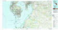 |
Bartow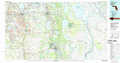 |
Vero Beach |
Sarasota |
Arcadia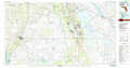 |
Fort Pierce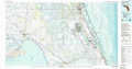 |
Charlotte Harbor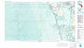 |
Fort Myers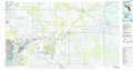 |
West Palm Beach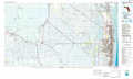 |
> Back to 27080a1 at 1:250,000 scale
> Back to U.S. Topo Maps home
1:24,000 Topo Quads covered by the spatial extent of this 100k map (Arcadia)
|
Ona 
|
Zolfo Springs 
|
Sweetwater 
|
Crewsville 
|
Sebring 
|
Lorida 
|
Basinger Nw 
|
Basinger 
|
|
Limestone 
|
Gardner 
|
Crewsville Sw 
|
Crewsville Se 
|
Lake June In Winter 
|
Lake Placid 
|
Basinger Sw 
|
Fort Basinger 
|
|
Nocatee 
|
Arcadia 
|
Long Island Marsh Nw 
|
Long Island Marsh Ne 
|
Venus Nw 
|
Childs 
|
Brighton Nw 
|
Brighton 
|
|
Fort Ogden 
|
Arcadia Se 
|
Long Island Marsh Sw 
|
Long Island Marsh Se 
|
Venus Sw 
|
Venus 
|
Brighton Sw 
|
Brighton Se 
|
