Virginia Point Topo Map Texas
To zoom in, hover over the map of Virginia Point
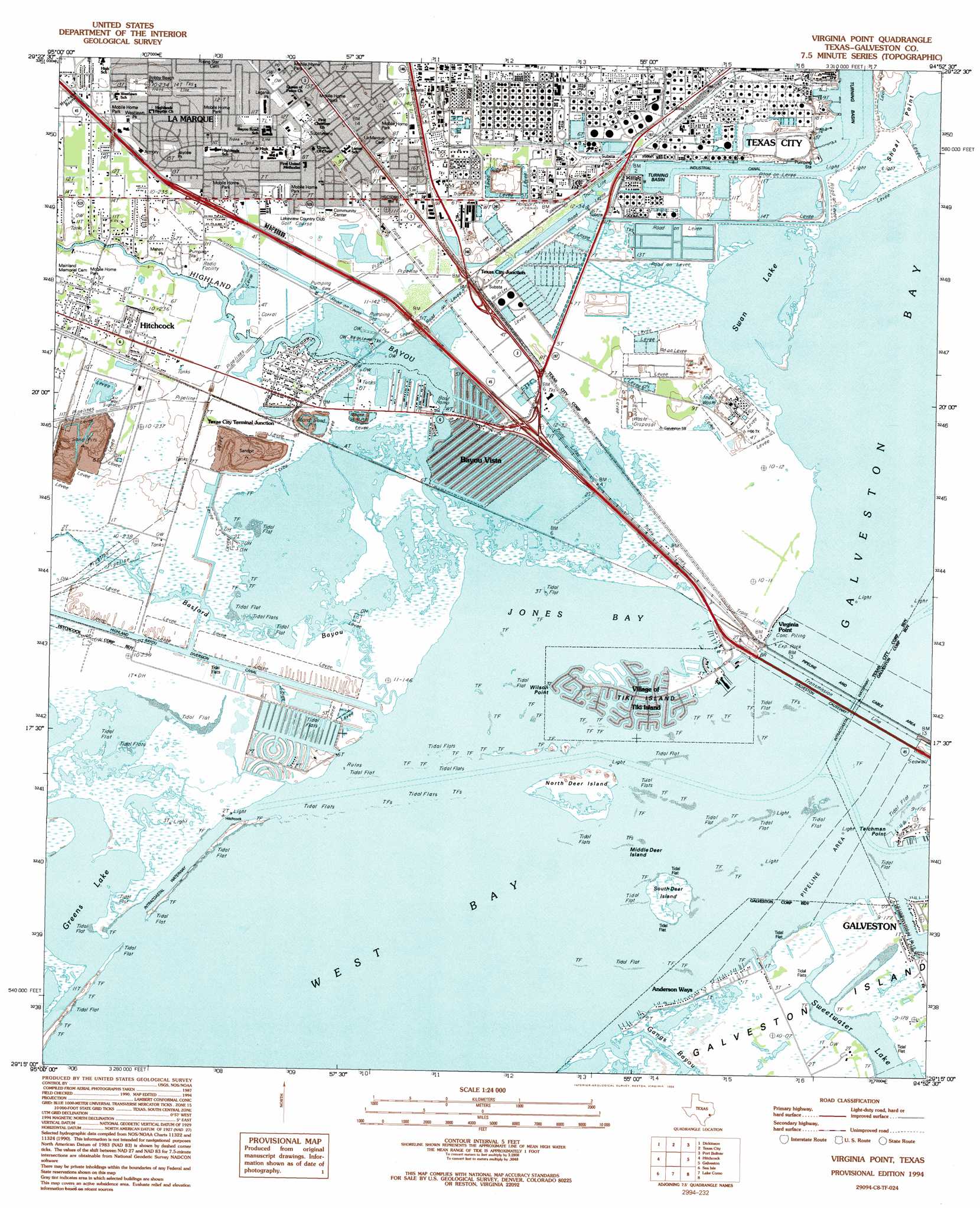
USGS Topo Quad 29094c8 - 1:24,000 scale
| Topo Map Name: | Virginia Point |
| USGS Topo Quad ID: | 29094c8 |
| Print Size: | ca. 21 1/4" wide x 27" high |
| Southeast Coordinates: | 29.25° N latitude / 94.875° W longitude |
| Map Center Coordinates: | 29.3125° N latitude / 94.9375° W longitude |
| U.S. State: | TX |
| Filename: | o29094c8.jpg |
| Download Map JPG Image: | Virginia Point topo map 1:24,000 scale |
| Map Type: | Topographic |
| Topo Series: | 7.5´ |
| Map Scale: | 1:24,000 |
| Source of Map Images: | United States Geological Survey (USGS) |
| Alternate Map Versions: |
Virginia Point TX 1929 Download PDF Buy paper map Virginia Point TX 1943, updated 1952 Download PDF Buy paper map Virginia Point TX 1954, updated 1956 Download PDF Buy paper map Virginia Point TX 1954, updated 1970 Download PDF Buy paper map Virginia Point TX 1954, updated 1977 Download PDF Buy paper map Virginia Point TX 1994, updated 1994 Download PDF Buy paper map Virginia Point TX 1995, updated 2000 Download PDF Buy paper map Virginia Point TX 2010 Download PDF Buy paper map Virginia Point TX 2013 Download PDF Buy paper map Virginia Point TX 2016 Download PDF Buy paper map |
1:24,000 Topo Quads surrounding Virginia Point
Friendswood |
League City |
Bacliff |
Smith Point |
Lake Stephenson |
Algoa |
Dickinson |
Texas City |
Port Bolivar |
Flake |
Mustang Bayou |
Hitchcock |
Virginia Point |
Galveston |
The Jetties |
Hoskins Mound |
Sea Isle |
Lake Como |
||
Christmas Point |
San Luis Pass |
> Back to 29094a1 at 1:100,000 scale
> Back to 29094a1 at 1:250,000 scale
> Back to U.S. Topo Maps home
Virginia Point topo map: Gazetteer
Virginia Point: Bays
Campbell Bayou elevation 0m 0′Jones Bay elevation 0m 0′
West Bay elevation 0m 0′
Virginia Point: Bridges
Galveston Causeway elevation 8m 26′Virginia Point: Canals
Barge Canal elevation 0m 0′Highland Bayou Diversion Channel elevation 1m 3′
Industrial Canal elevation 0m 0′
Virginia Point: Capes
Shoal Point elevation 2m 6′Teichman Point elevation 1m 3′
Wilson Point elevation 0m 0′
Virginia Point: Islands
Flamingo Isles elevation 2m 6′Middle Deer Island elevation 0m 0′
North Deer Island elevation 1m 3′
South Deer Island elevation 2m 6′
Tiki Island elevation 1m 3′
Virginia Point: Lakes
Greens Lake elevation 1m 3′Swan Lake elevation 0m 0′
Sweetwater Lake elevation 0m 0′
Virginia Point: Parks
Bobby Beach Park elevation 5m 16′Etheredge Stadium elevation 4m 13′
Jaycee Park elevation 4m 13′
La Marque High School Baseball Field elevation 5m 16′
Lagana Park elevation 5m 16′
Mahan Park elevation 2m 6′
Westlawn Park elevation 4m 13′
Virginia Point: Populated Places
Anderson Ways elevation 2m 6′Bayou Vista elevation 2m 6′
La Marque elevation 5m 16′
Texas City Junction elevation 3m 9′
Texas City Terminal Junction elevation 3m 9′
Tiki Island elevation 2m 6′
Virginia Point elevation 0m 0′
Virginia Point: Streams
Basford Bayou elevation 0m 0′Highland Bayou elevation 0m 0′
Virginia Point digital topo map on disk
Buy this Virginia Point topo map showing relief, roads, GPS coordinates and other geographical features, as a high-resolution digital map file on DVD: