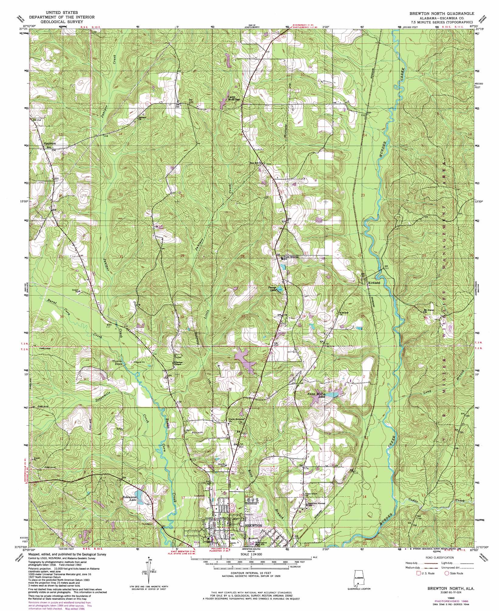
Brewton North Topo Map Alabama
To zoom in, hover over the map of Brewton North
USGS Topo Quad 31087b1 - 1:24,000 scale
| Topo Map Name: | Brewton North |
| USGS Topo Quad ID: | 31087b1 |
| Print Size: | ca. 21 1/4" wide x 27" high |
| Southeast Coordinates: | 31.125° N latitude / 87° W longitude |
| Map Center Coordinates: | 31.1875° N latitude / 87.0625° W longitude |
| U.S. State: | AL |
| Filename: | o31087b1.jpg |
| Download Map JPG Image: | Brewton North topo map 1:24,000 scale |
| Map Type: | Topographic |
| Topo Series: | 7.5´ |
| Map Scale: | 1:24,000 |
| Source of Map Images: | United States Geological Survey (USGS) |
| Alternate Map Versions: |
Brewton North AL 1960, updated 1961 Download PDF Buy paper map Brewton North AL 1960, updated 1977 Download PDF Buy paper map Brewton North AL 1960, updated 1986 Download PDF Buy paper map Brewton North AL 2011 Download PDF Buy paper map Brewton North AL 2014 Download PDF Buy paper map |
1:24,000 Topo Quads surrounding Brewton North
Excel |
Repton |
Belleville |
Evergreen |
Old Town |
Frisco City Se |
Range |
Castleberry |
Nymph |
Brooklyn |
Barnett Crossroads |
Wallace |
Brewton North |
Shipps Creek |
Damascus |
Flomaton |
Pollard |
Brewton South |
Roberts |
Parker Springs |
Century |
Jay |
Fidelis |
Mclellan |
Hurricane Lake |
> Back to 31087a1 at 1:100,000 scale
> Back to 31086a1 at 1:250,000 scale
> Back to U.S. Topo Maps home
Brewton North topo map: Gazetteer
Brewton North: Dams
E J Moran Number One Dam elevation 47m 154′E J Moran Number Two Dam elevation 45m 147′
H R Sherrer Dam elevation 45m 147′
Huxford Dam elevation 50m 164′
McMillan Dam elevation 67m 219′
Robinson Dam elevation 38m 124′
Brewton North: Lakes
Perrys Lake elevation 55m 180′Brewton North: Populated Places
Appleton elevation 72m 236′Kirkland elevation 37m 121′
Brewton North: Rapids
Tippins Eddy elevation 30m 98′Brewton North: Reservoirs
Anna Maria Lake elevation 47m 154′Lake Huxford elevation 50m 164′
Lake McMillan elevation 67m 219′
Moran Lake One elevation 47m 154′
Moran Lake Two elevation 45m 147′
Robinsons Lake elevation 38m 124′
W R Sherrer Lake elevation 45m 147′
Brewton North: Streams
Cedar Creek elevation 24m 78′Juniper Creek elevation 30m 98′
Little Juniper Creek elevation 28m 91′
Long Branch elevation 24m 78′
Sevenmile Creek elevation 26m 85′
Brewton North digital topo map on disk
Buy this Brewton North topo map showing relief, roads, GPS coordinates and other geographical features, as a high-resolution digital map file on DVD:
Gulf Coast (LA, MS, AL, FL) & Southwestern Georgia
Buy digital topo maps: Gulf Coast (LA, MS, AL, FL) & Southwestern Georgia
 & Southwestern Georgia map DVD")