Baxterville Sw Topo Map Mississippi
To zoom in, hover over the map of Baxterville Sw
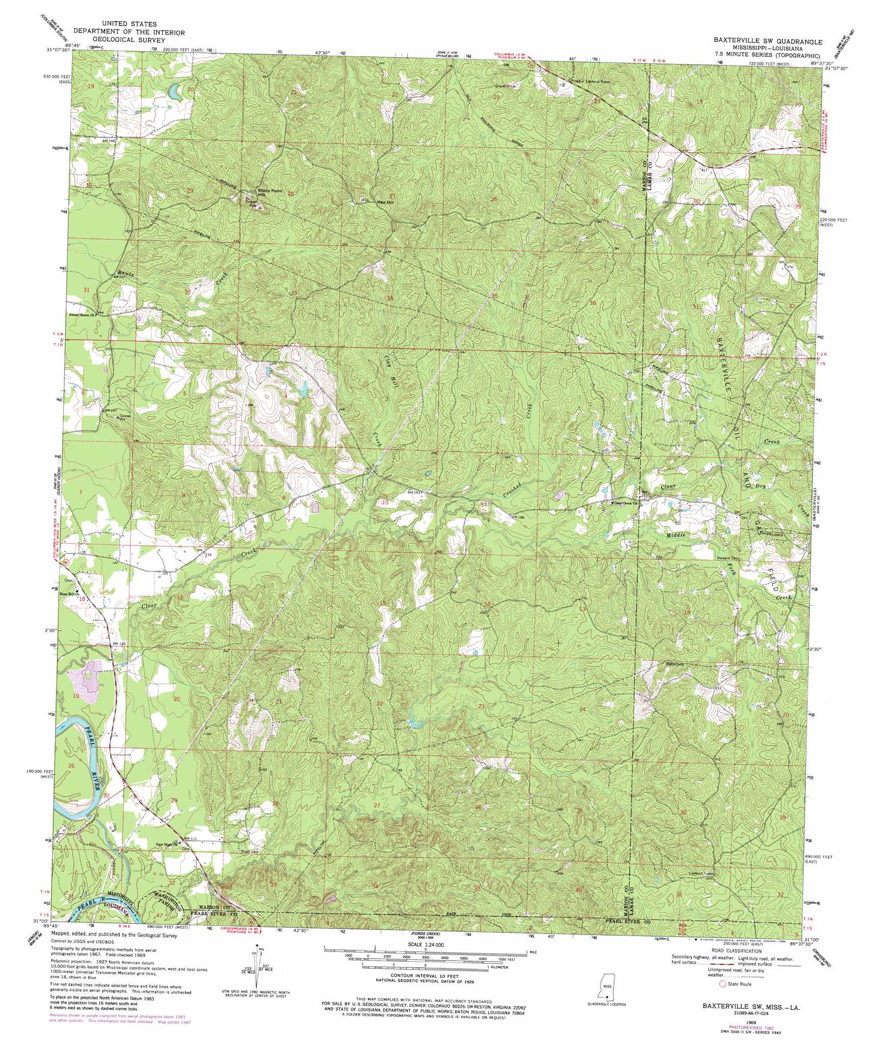
USGS Topo Quad 31089a6 - 1:24,000 scale
| Topo Map Name: | Baxterville Sw |
| USGS Topo Quad ID: | 31089a6 |
| Print Size: | ca. 21 1/4" wide x 27" high |
| Southeast Coordinates: | 31° N latitude / 89.625° W longitude |
| Map Center Coordinates: | 31.0625° N latitude / 89.6875° W longitude |
| U.S. States: | MS, LA |
| Filename: | o31089a6.jpg |
| Download Map JPG Image: | Baxterville Sw topo map 1:24,000 scale |
| Map Type: | Topographic |
| Topo Series: | 7.5´ |
| Map Scale: | 1:24,000 |
| Source of Map Images: | United States Geological Survey (USGS) |
| Alternate Map Versions: |
Baxterville SW MS 1969, updated 1971 Download PDF Buy paper map Baxterville SW MS 1969, updated 1978 Download PDF Buy paper map Baxterville SW MS 1969, updated 1982 Download PDF Buy paper map Baxterville SW MS 1969, updated 1986 Download PDF Buy paper map Baxterville SW MS 2012 Download PDF Buy paper map Baxterville SW MS 2015 Download PDF Buy paper map |
1:24,000 Topo Quads surrounding Baxterville Sw
Morgantown |
Columbia North |
Improve |
Oloh |
Hattiesburg Sw |
Sandy Hook Nw |
Columbia South |
Pinebur |
Baxterville Ne |
Purvis |
Dexter |
Sandy Hook |
Baxterville Sw |
Baxterville |
Lumberton |
State Line |
Angie |
Fords Creek |
Orvisburg |
Hillsdale |
Bogalusa West |
Bogalusa East |
White Sand |
Poplarville |
Big Swamp |
> Back to 31089a1 at 1:100,000 scale
> Back to 31088a1 at 1:250,000 scale
> Back to U.S. Topo Maps home
Baxterville Sw topo map: Gazetteer
Baxterville Sw: Dams
Bass Lake Dam elevation 71m 232′Kobrock Lake Dam elevation 43m 141′
Baxterville Sw: Oilfields
Baxterville Oil and Gas Field elevation 72m 236′Baxterville Sw: Populated Places
Rouse elevation 121m 396′Baxterville Sw: Streams
Clay Hill Creek elevation 41m 134′Clear Creek elevation 27m 88′
Crooked Creek elevation 44m 144′
Dry Creek elevation 61m 200′
Middle Fork Creek elevation 51m 167′
White Oak Creek elevation 60m 196′
Baxterville Sw: Summits
Hub HIll elevation 123m 403′Red Hill elevation 117m 383′
Stony Point Hill elevation 104m 341′
Baxterville Sw digital topo map on disk
Buy this Baxterville Sw topo map showing relief, roads, GPS coordinates and other geographical features, as a high-resolution digital map file on DVD:
Gulf Coast (LA, MS, AL, FL) & Southwestern Georgia
Buy digital topo maps: Gulf Coast (LA, MS, AL, FL) & Southwestern Georgia
 & Southwestern Georgia map DVD")