Tepee Butte Sw Topo Map Texas
To zoom in, hover over the map of Tepee Butte Sw
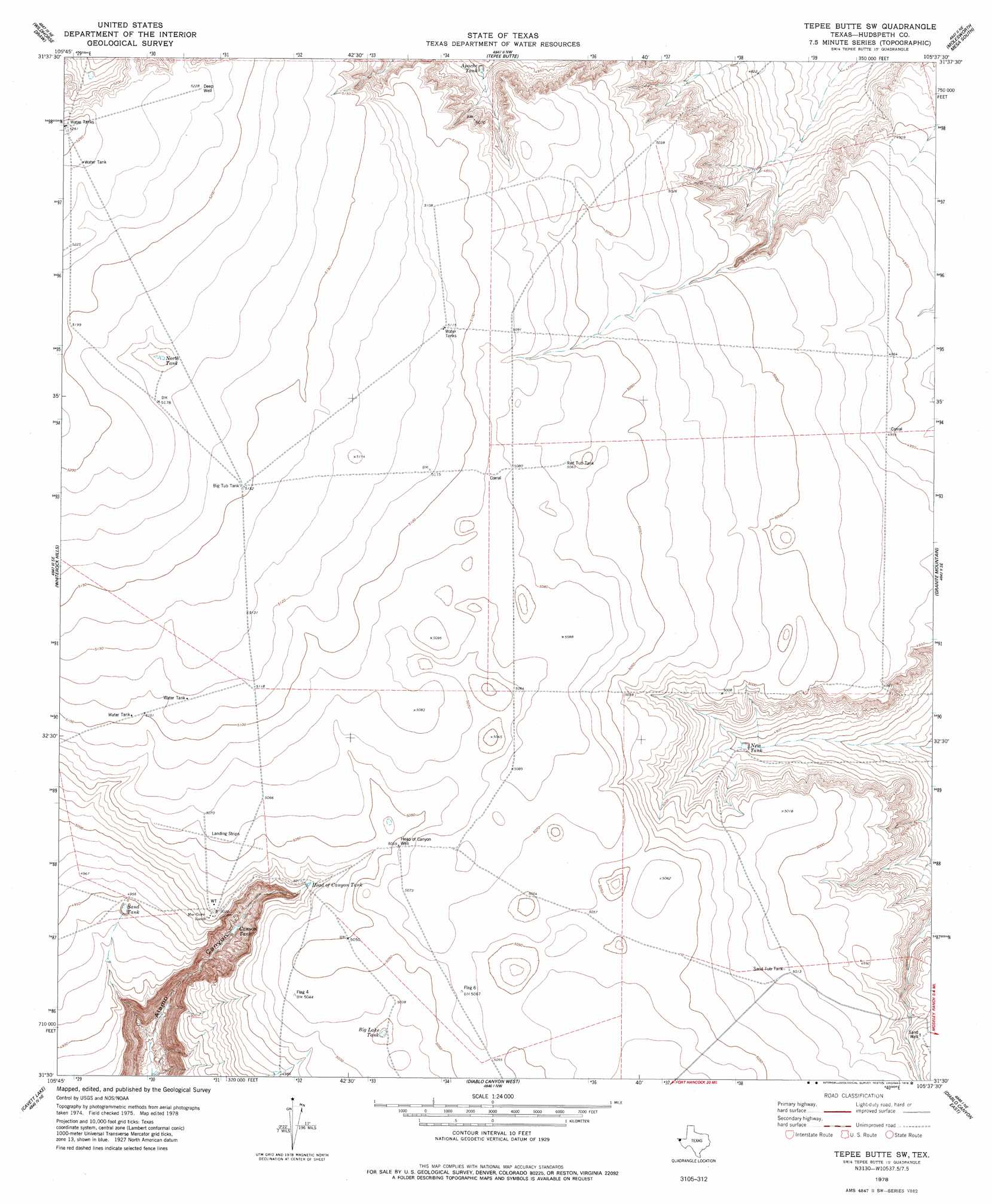
USGS Topo Quad 31105e6 - 1:24,000 scale
| Topo Map Name: | Tepee Butte Sw |
| USGS Topo Quad ID: | 31105e6 |
| Print Size: | ca. 21 1/4" wide x 27" high |
| Southeast Coordinates: | 31.5° N latitude / 105.625° W longitude |
| Map Center Coordinates: | 31.5625° N latitude / 105.6875° W longitude |
| U.S. State: | TX |
| Filename: | o31105e6.jpg |
| Download Map JPG Image: | Tepee Butte Sw topo map 1:24,000 scale |
| Map Type: | Topographic |
| Topo Series: | 7.5´ |
| Map Scale: | 1:24,000 |
| Source of Map Images: | United States Geological Survey (USGS) |
| Alternate Map Versions: |
Tepee Butte SW TX 1978, updated 1978 Download PDF Buy paper map Tepee Butte SW TX 2010 Download PDF Buy paper map Tepee Butte SW TX 2013 Download PDF Buy paper map Tepee Butte SW TX 2016 Download PDF Buy paper map |
1:24,000 Topo Quads surrounding Tepee Butte Sw
Phone Line Canyon |
Buckhorn Draw West |
Buckhorn Draw East |
Molesworth Mesa North |
Cornudas |
Padre Canyon |
Wildhorse Draw |
Tepee Butte |
Molesworth Mesa South |
Adobe House Tank |
T P Well |
Whiterock Hills |
Tepee Butte Sw |
Granite Mountain |
Baylor Draw |
Fort Hancock Nw |
Cavett Lake |
Diablo Canyon West |
Diablo Canyon East |
Gunsight Hills North |
Acala |
Fort Hancock |
Campo Grande Mountain |
Small |
Gunsight Hills South |
> Back to 31105e1 at 1:100,000 scale
> Back to 31104a1 at 1:250,000 scale
> Back to U.S. Topo Maps home
Tepee Butte Sw topo map: Gazetteer
Tepee Butte Sw: Reservoirs
Apache Tank elevation 1509m 4950′Big Lake Tank elevation 1530m 5019′
Big Tub Tank elevation 1571m 5154′
Canyon Tank elevation 1468m 4816′
Head of Canyon Tank elevation 1526m 5006′
New Tank elevation 1494m 4901′
North Tank elevation 1572m 5157′
Red Tub Tank elevation 1544m 5065′
Sand Tank elevation 1509m 4950′
Sand Tub Tank elevation 1529m 5016′
Tepee Butte Sw: Springs
Alamo Springs elevation 1553m 5095′Tepee Butte Sw: Wells
Head of Canyon Well elevation 1542m 5059′Tepee Butte Sw digital topo map on disk
Buy this Tepee Butte Sw topo map showing relief, roads, GPS coordinates and other geographical features, as a high-resolution digital map file on DVD: