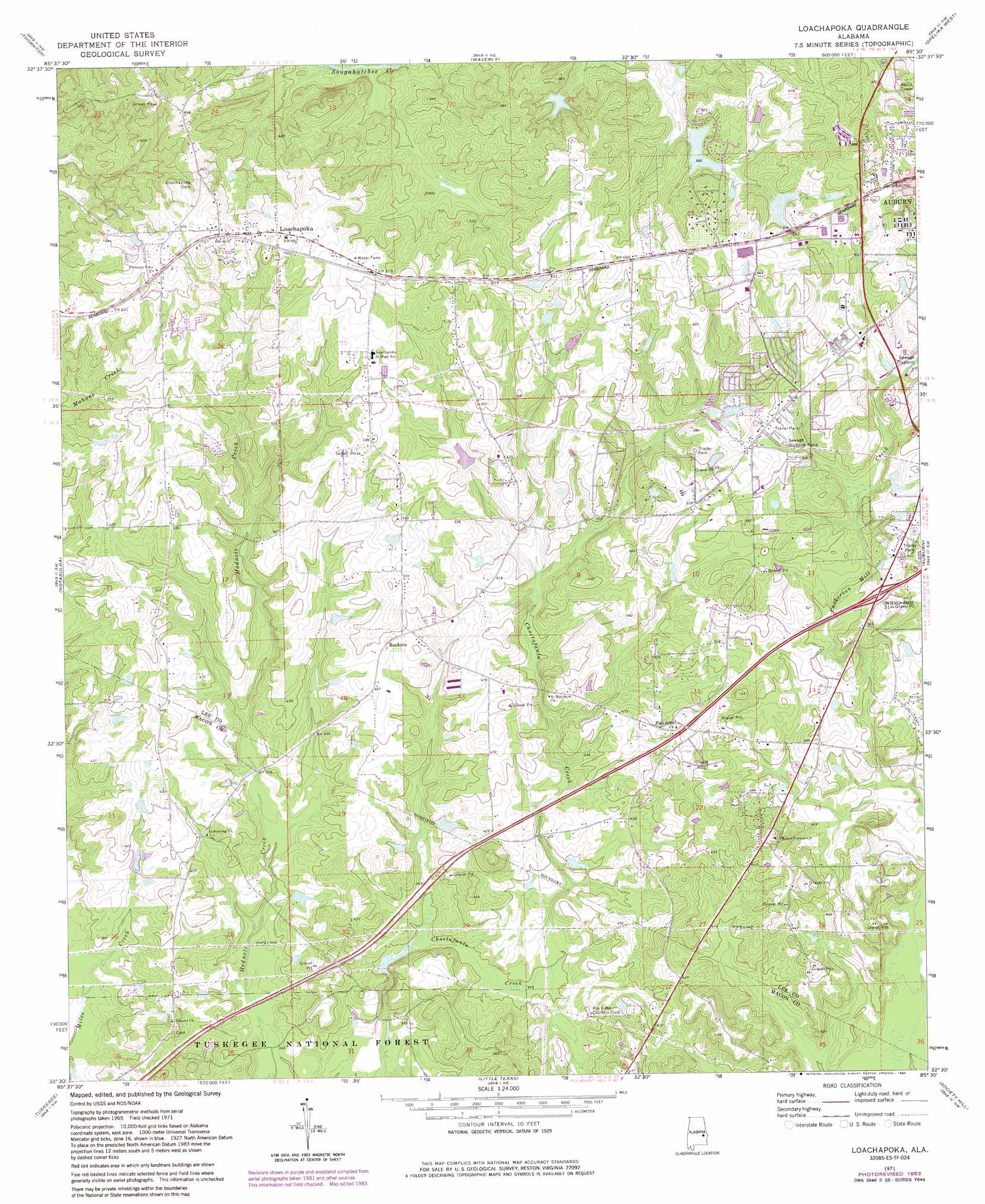
Loachapoka Topo Map Alabama
To zoom in, hover over the map of Loachapoka
USGS Topo Quad 32085e5 - 1:24,000 scale
| Topo Map Name: | Loachapoka |
| USGS Topo Quad ID: | 32085e5 |
| Print Size: | ca. 21 1/4" wide x 27" high |
| Southeast Coordinates: | 32.5° N latitude / 85.5° W longitude |
| Map Center Coordinates: | 32.5625° N latitude / 85.5625° W longitude |
| U.S. State: | AL |
| Filename: | o32085e5.jpg |
| Download Map JPG Image: | Loachapoka topo map 1:24,000 scale |
| Map Type: | Topographic |
| Topo Series: | 7.5´ |
| Map Scale: | 1:24,000 |
| Source of Map Images: | United States Geological Survey (USGS) |
| Alternate Map Versions: |
Loachapoka AL 1971, updated 1973 Download PDF Buy paper map Loachapoka AL 1971, updated 1984 Download PDF Buy paper map Loachapoka AL 1971, updated 1984 Download PDF Buy paper map Loachapoka AL 1998, updated 2001 Download PDF Buy paper map Loachapoka AL 2011 Download PDF Buy paper map Loachapoka AL 2014 Download PDF Buy paper map |
| FStopo: | US Forest Service topo Loachapoka is available: Download FStopo PDF Download FStopo TIF |
1:24,000 Topo Quads surrounding Loachapoka
Dadeville |
Camp Hill |
Camp Hill Se |
Moorefield |
Cusseta |
Ponders |
Thornton |
Waverly |
Opelika West |
Opelika East |
Carrville |
Notasulga |
Loachapoka |
Auburn |
Parkers Crossroads |
La Place |
Tuskegee |
Little Texas |
Society Hill |
Marvyn |
Hardaway |
Davisville |
Warriorstand |
Creek Stand |
Hatchechubbee |
> Back to 32085e1 at 1:100,000 scale
> Back to 32084a1 at 1:250,000 scale
> Back to U.S. Topo Maps home
Loachapoka topo map: Gazetteer
Loachapoka: Crossings
Interchange 51 elevation 159m 521′Loachapoka: Dams
E T Conway Number 1 Dam elevation 164m 538′Folmar Dam elevation 177m 580′
Plainsman Club Dam elevation 194m 636′
Vaughans Mill Pond Dam elevation 105m 344′
Loachapoka: Lakes
Allens Pond elevation 197m 646′Colliers Pond elevation 151m 495′
Conways Lake elevation 165m 541′
Loachapoka: Parks
Loachapoka Historic District elevation 205m 672′Uchee Shooting Range elevation 106m 347′
Loachapoka: Populated Places
Beehive elevation 149m 488′Conner Estates elevation 172m 564′
Duggar Farms elevation 166m 544′
Kuderna Acres elevation 163m 534′
Loachapoka elevation 207m 679′
Ridgewood Village elevation 190m 623′
Sand Hill elevation 146m 479′
Stonegate elevation 182m 597′
Willow Creek Farms elevation 195m 639′
Loachapoka: Post Offices
Loachapoka Post Office elevation 204m 669′Loachapoka: Reservoirs
Conway Fish Pond Number One elevation 164m 538′Kuderna Lake elevation 161m 528′
Little and Stuckys Lake elevation 177m 580′
Meadows Lake elevation 133m 436′
Pam Lake elevation 151m 495′
Plainsman Lake elevation 194m 636′
Richards Pond elevation 184m 603′
Vaughans Mill Pond elevation 105m 344′
Wards Pond elevation 123m 403′
Websters Pond elevation 200m 656′
Yeagers Pond elevation 169m 554′
Loachapoka: Streams
Mahone Creek elevation 136m 446′Loachapoka digital topo map on disk
Buy this Loachapoka topo map showing relief, roads, GPS coordinates and other geographical features, as a high-resolution digital map file on DVD:
Gulf Coast (LA, MS, AL, FL) & Southwestern Georgia
Buy digital topo maps: Gulf Coast (LA, MS, AL, FL) & Southwestern Georgia
 & Southwestern Georgia map DVD")