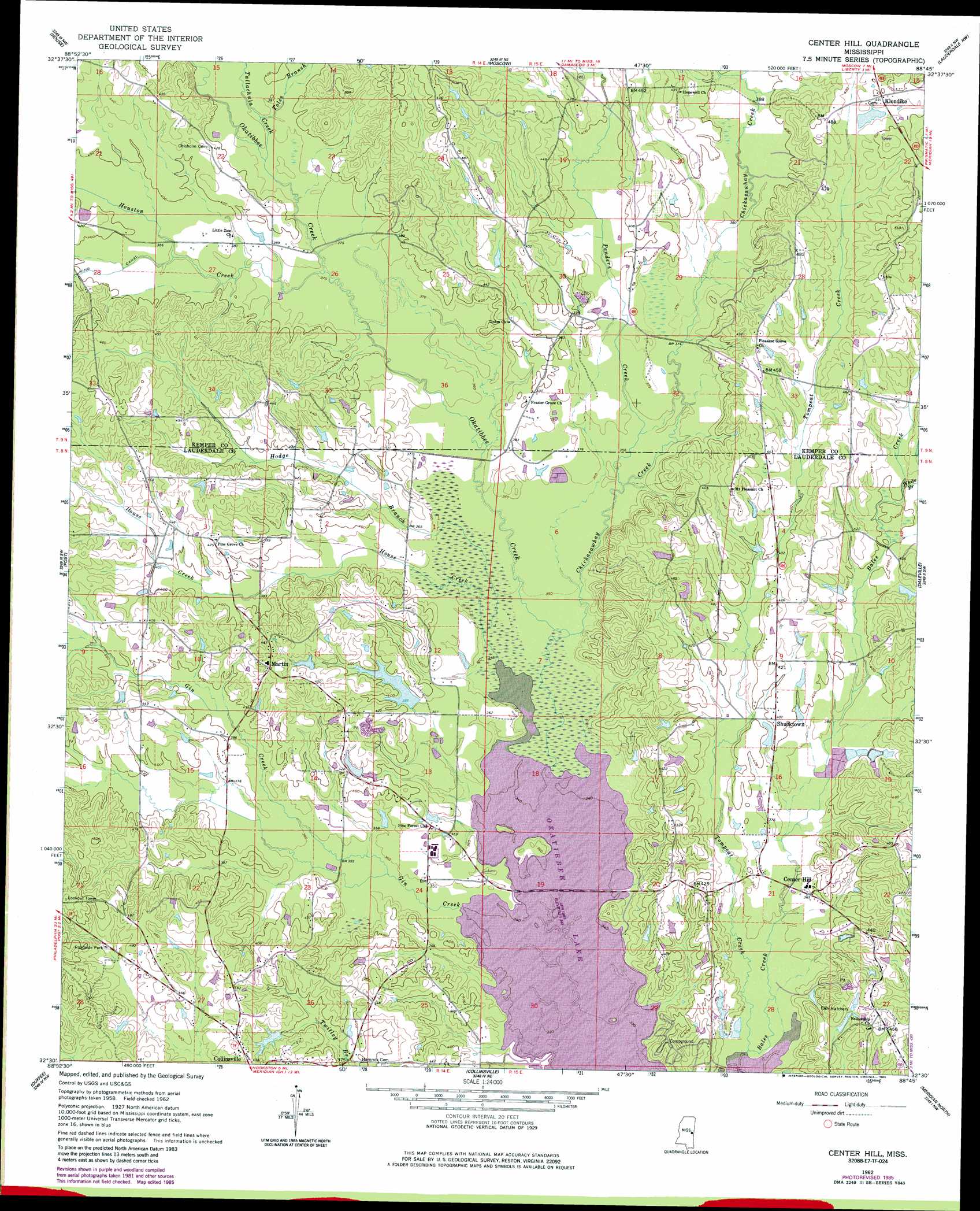
Center Hill Topo Map Mississippi
To zoom in, hover over the map of Center Hill
USGS Topo Quad 32088e7 - 1:24,000 scale
| Topo Map Name: | Center Hill |
| USGS Topo Quad ID: | 32088e7 |
| Print Size: | ca. 21 1/4" wide x 27" high |
| Southeast Coordinates: | 32.5° N latitude / 88.75° W longitude |
| Map Center Coordinates: | 32.5625° N latitude / 88.8125° W longitude |
| U.S. State: | MS |
| Filename: | o32088e7.jpg |
| Download Map JPG Image: | Center Hill topo map 1:24,000 scale |
| Map Type: | Topographic |
| Topo Series: | 7.5´ |
| Map Scale: | 1:24,000 |
| Source of Map Images: | United States Geological Survey (USGS) |
| Alternate Map Versions: |
Center Hill MS 1962, updated 1963 Download PDF Buy paper map Center Hill MS 1962, updated 1982 Download PDF Buy paper map Center Hill MS 1962, updated 1985 Download PDF Buy paper map Center Hill MS 2012 Download PDF Buy paper map Center Hill MS 2015 Download PDF Buy paper map |
1:24,000 Topo Quads surrounding Center Hill
Philadelphia |
Owl Creek |
Lynville |
De Kalb |
Townsend |
Deemer |
House |
Moscow |
Lauderdale Nw |
Oak Grove |
Union East |
Post |
Center Hill |
Daleville |
Lauderdale |
Decatur |
Duffee |
Collinsville |
Meridian North |
Toomsuba |
Hickory |
Chunky |
Meehan |
Meridian South |
Vimville |
> Back to 32088e1 at 1:100,000 scale
> Back to 32088a1 at 1:250,000 scale
> Back to U.S. Topo Maps home
Center Hill topo map: Gazetteer
Center Hill: Dams
Bounds Pond Dam elevation 116m 380′Duluth Snowden Pond Dam elevation 128m 419′
E T Brown Pond Dam elevation 134m 439′
J W Wilson Pond Dam elevation 129m 423′
M C Williams Pond Dam elevation 110m 360′
Martha Cobb Pond Dam elevation 122m 400′
Murry Rogers Catfish Ponds Dam elevation 136m 446′
R E Scruggs Pond Dam elevation 125m 410′
Smith Pond Dam elevation 116m 380′
W O Wilkerson Pond Dam elevation 144m 472′
Center Hill: Parks
Okatibbee State Wildlife Area elevation 107m 351′Center Hill: Populated Places
Center Hill elevation 114m 374′Klondike elevation 152m 498′
Martin elevation 140m 459′
Oktibbeha (historical) elevation 116m 380′
Shucktown elevation 123m 403′
Center Hill: Streams
Chickasawhay Creek elevation 103m 337′Gin Creek elevation 98m 321′
Hodge Branch elevation 105m 344′
House Creek elevation 98m 321′
Houston Creek elevation 111m 364′
Penders Creek elevation 107m 351′
Tallachula Creek elevation 113m 370′
Toles Branch elevation 115m 377′
Tompeat Creek elevation 103m 337′
White Branch elevation 122m 400′
Center Hill digital topo map on disk
Buy this Center Hill topo map showing relief, roads, GPS coordinates and other geographical features, as a high-resolution digital map file on DVD:
Gulf Coast (LA, MS, AL, FL) & Southwestern Georgia
Buy digital topo maps: Gulf Coast (LA, MS, AL, FL) & Southwestern Georgia
 & Southwestern Georgia map DVD")