Lafayette Topo Map Texas
To zoom in, hover over the map of Lafayette
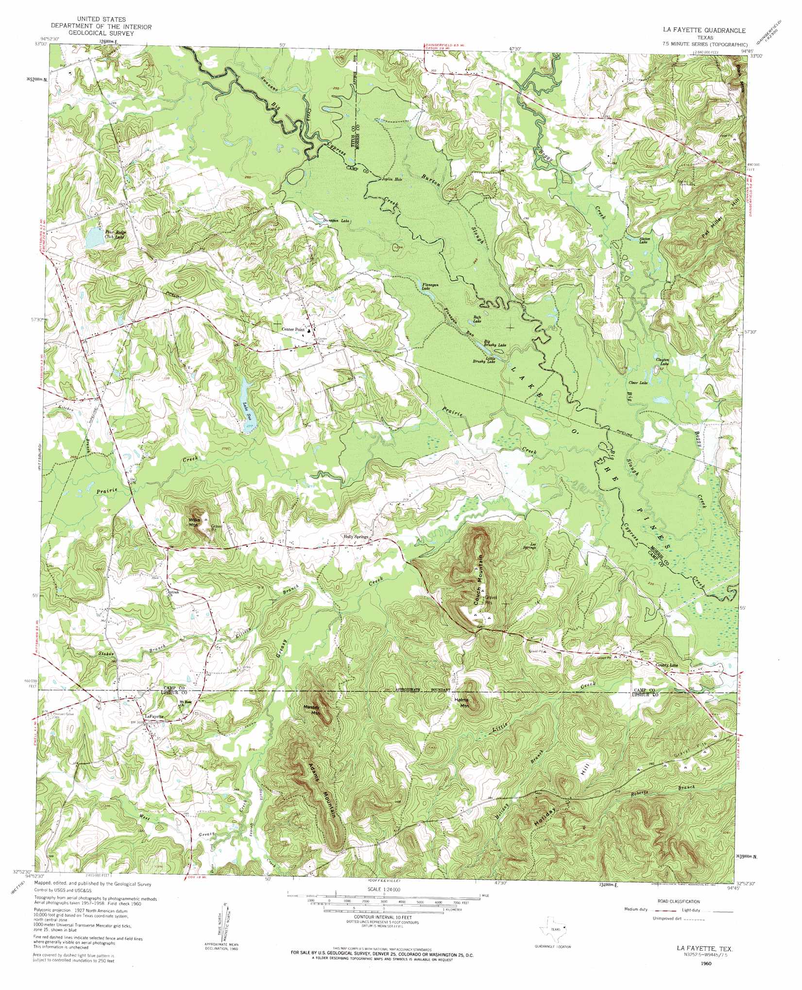
USGS Topo Quad 32094h7 - 1:24,000 scale
| Topo Map Name: | Lafayette |
| USGS Topo Quad ID: | 32094h7 |
| Print Size: | ca. 21 1/4" wide x 27" high |
| Southeast Coordinates: | 32.875° N latitude / 94.75° W longitude |
| Map Center Coordinates: | 32.9375° N latitude / 94.8125° W longitude |
| U.S. State: | TX |
| Filename: | o32094h7.jpg |
| Download Map JPG Image: | Lafayette topo map 1:24,000 scale |
| Map Type: | Topographic |
| Topo Series: | 7.5´ |
| Map Scale: | 1:24,000 |
| Source of Map Images: | United States Geological Survey (USGS) |
| Alternate Map Versions: |
La Fayette TX 1960, updated 1962 Download PDF Buy paper map La Fayette TX 1960, updated 1962 Download PDF Buy paper map Lafayette TX 2010 Download PDF Buy paper map Lafayette TX 2013 Download PDF Buy paper map Lafayette TX 2016 Download PDF Buy paper map |
1:24,000 Topo Quads surrounding Lafayette
Winfield |
Mount Pleasant |
Cookville |
Naples |
Marietta |
Monticello |
Harvard |
Cason |
Daingerfield |
Sardis |
Leesburg |
Pittsburg |
Lafayette |
Lone Star |
Avinger |
Thomas |
Bettie |
Coffeeville |
Ore City |
Lassater |
Pritchett |
Gilmer |
Glenwood |
Ashland |
Harleton |
> Back to 32094e1 at 1:100,000 scale
> Back to 32094a1 at 1:250,000 scale
> Back to U.S. Topo Maps home
Lafayette topo map: Gazetteer
Lafayette: Bends
Joplin Hole elevation 75m 246′Lafayette: Dams
Lake Sue Dam elevation 81m 265′Pine Ridge Club Dam elevation 95m 311′
Lafayette: Guts
Big Slough elevation 72m 236′Lafayette: Lakes
Big Brushy Lake elevation 73m 239′Clayton Lake elevation 73m 239′
Clear Lake elevation 73m 239′
Dunagan Lake elevation 76m 249′
Flanagan Lake elevation 74m 242′
Little Brushy Lake elevation 73m 239′
Rafe Lake elevation 75m 246′
Slaton Lake elevation 76m 249′
Lafayette: Populated Places
Center Point elevation 101m 331′Holly Springs elevation 89m 291′
LaFayette elevation 110m 360′
Lafayette: Reservoirs
Lake Sue elevation 82m 269′Pine Ridge Club Lake elevation 95m 311′
Lafayette: Springs
Lee Springs elevation 84m 275′Lafayette: Streams
Boggy Creek elevation 71m 232′Burton Slough elevation 73m 239′
Dixon Creek elevation 85m 278′
Ellison Branch elevation 79m 259′
Flanagan Run elevation 73m 239′
Greasy Creek elevation 72m 236′
Holiday Branch elevation 86m 282′
Kitchen Branch elevation 81m 265′
Prairie Creek elevation 72m 236′
South Greasy Creek elevation 83m 272′
Stoker Branch elevation 91m 298′
Swauano Creek elevation 76m 249′
West Greasy Creek elevation 83m 272′
Lafayette: Summits
Adams Mountain elevation 169m 554′Couch Mountain elevation 161m 528′
Helms Mountain elevation 159m 521′
Holiday Hill elevation 163m 534′
Massey Mountain elevation 160m 524′
Pat Miller Hill elevation 121m 396′
Wilks Mountain elevation 152m 498′
Lafayette digital topo map on disk
Buy this Lafayette topo map showing relief, roads, GPS coordinates and other geographical features, as a high-resolution digital map file on DVD: