Ables Springs Topo Map Texas
To zoom in, hover over the map of Ables Springs
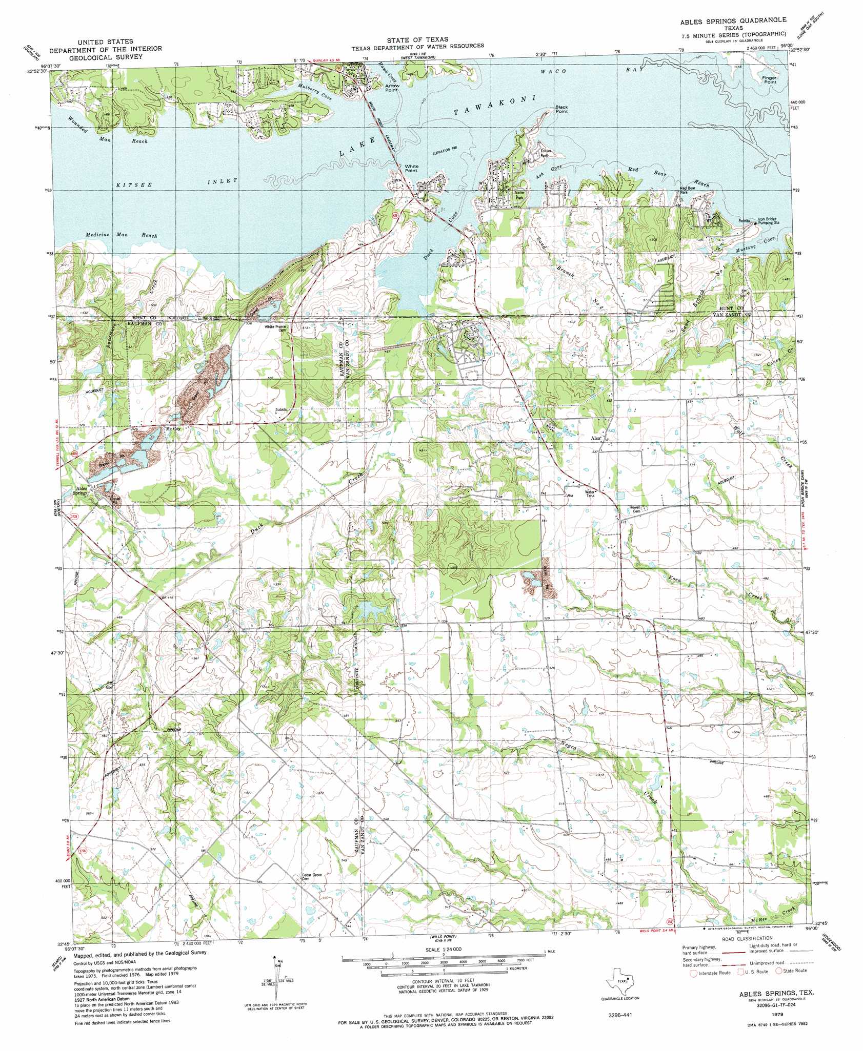
USGS Topo Quad 32096g1 - 1:24,000 scale
| Topo Map Name: | Ables Springs |
| USGS Topo Quad ID: | 32096g1 |
| Print Size: | ca. 21 1/4" wide x 27" high |
| Southeast Coordinates: | 32.75° N latitude / 96° W longitude |
| Map Center Coordinates: | 32.8125° N latitude / 96.0625° W longitude |
| U.S. State: | TX |
| Filename: | o32096g1.jpg |
| Download Map JPG Image: | Ables Springs topo map 1:24,000 scale |
| Map Type: | Topographic |
| Topo Series: | 7.5´ |
| Map Scale: | 1:24,000 |
| Source of Map Images: | United States Geological Survey (USGS) |
| Alternate Map Versions: |
Ables Springs TX 1979, updated 1987 Download PDF Buy paper map Ables Springs TX 2011 Download PDF Buy paper map Ables Springs TX 2012 Download PDF Buy paper map Ables Springs TX 2016 Download PDF Buy paper map |
1:24,000 Topo Quads surrounding Ables Springs
Josephine |
Greenville Sw |
Greenville Se |
Lone Oak North |
Miller Grove |
Royse City |
Quinlan |
West Tawakoni |
Lone Oak South |
Emory North |
Terrell North |
Poetry |
Ables Springs |
Iron Bridge Dam |
Emory South |
Terrell South |
Elmo |
Wills Point |
Edgewood |
Fruitvale |
Kaufman |
Ola |
Cedarvale |
Myrtle Springs |
Canton |
> Back to 32096e1 at 1:100,000 scale
> Back to 32096a1 at 1:250,000 scale
> Back to U.S. Topo Maps home
Ables Springs topo map: Gazetteer
Ables Springs: Bays
Ash Cove elevation 133m 436′Duck Cove elevation 133m 436′
Kitsee Inlet elevation 133m 436′
Mulberry Cove elevation 133m 436′
Mustang Cove elevation 133m 436′
Waco Bay elevation 133m 436′
Ables Springs: Bridges
Duck Cove Bridge elevation 133m 436′White Point Causeway elevation 134m 439′
Ables Springs: Capes
Arrow Point elevation 133m 436′Black Point elevation 133m 436′
Finger Point elevation 135m 442′
White Point elevation 134m 439′
Ables Springs: Channels
Medicine Man Reach elevation 133m 436′Red Bear Reach elevation 133m 436′
Wounded Man Reach elevation 133m 436′
Ables Springs: Dams
Goettsche Lake Dam elevation 160m 524′Ables Springs: Parks
Red Bear Park elevation 142m 465′Red Deer Park elevation 133m 436′
Ables Springs: Populated Places
Ables Springs elevation 158m 518′Alsa elevation 164m 538′
Cedar Grove elevation 174m 570′
McCoy elevation 164m 538′
Ables Springs: Reservoirs
Goettsche Lake elevation 160m 524′Ables Springs: Springs
Ables Springs elevation 159m 521′Ables Springs: Streams
Duck Creek elevation 133m 436′Sand Branch Number One elevation 134m 439′
Sand Branch Number Two elevation 134m 439′
Sycamore Creek elevation 134m 439′
Ables Springs digital topo map on disk
Buy this Ables Springs topo map showing relief, roads, GPS coordinates and other geographical features, as a high-resolution digital map file on DVD: